
How to get here
Port-Royal National Historic Site
Port-Royal National Historic Site is located in Port Royal, Nova Scotia.
Map of Nova Scotia National Historic Sites
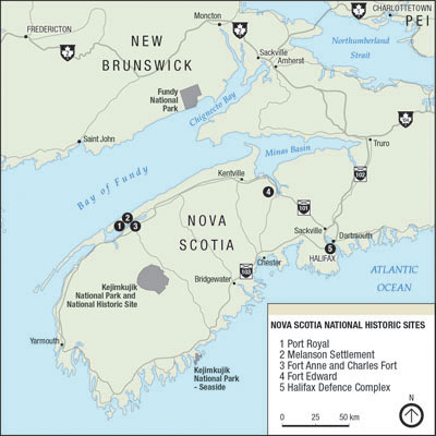
Map legend
1 - Port Royal National Historic Site
2 - Melanson Settlement National Historic site
3 - Fort Anne and Charles Fort National Historic Site
4 - Fort Edward National Historic Site
5 - Halifax Defence Complex
Address:
53 Historic Lane
Port Royal, Nova Scotia, B0S 1K0
GPS coordinates:
N 44.71146
W 065.60947
Directions
Car
Port-Royal is located just west of Annapolis Royal and Granville Ferry.
Take Exit 22 off Highway 101 and continue north on Route 8 to Annapolis Royal.
At the traffic lights, turn right on Route 1, and cross the causeway.
Take the first left and follow the signs indicating Port-Royal (10.5 km / 6.5 miles).
Driving time:
- From Halifax is approximately 2 hours.
- From Yarmouth is approximately 1.5 hours.
Air
The Halifax International Airport has regular flights to and from North America and Europe.
From the airport take Highway 102, to Exit 4B (Windsor/Annapolis Valley) and on to Highway 101.
Take Highway 101 to Exit 22 and follow the directions above.
Train
Via Rail has regular train service to the nearest train station at Halifax.
From Halifax, take Highway 102, to Exit 4B (Windsor/Annapolis Valley) and on to Highway 101.
Take Highway 101 to Exit 22 and follow the directions above.
Ferry
Bay Ferries offers ferry services to southwestern Nova Scotia.
The Fundy Rose
The Fundy Rose sails between Saint John, New Brunswick and Digby, Nova Scotia.
Driving time:
- Driving time from Digby to Annapolis Royal is approximately 30 minutes.
The CAT
The CAT sails between Portland, Maine and Yarmouth, Nova Scotia.
Driving time:
- Driving time from Yarmouth to Annapolis Royal is approximately 1.5 hours.
- Date modified :