
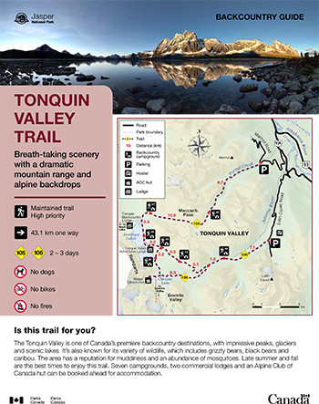
Breath-taking scenery with a dramatic mountain range and alpine backdrops
Tonquin Valley Trail
Jasper National Park
 Tonquin Valley Backcountry Guide (PDF, 1.6 MB)
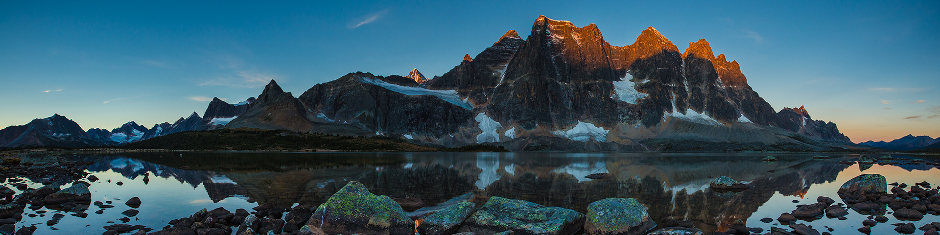
The Tonquin Valley is one of Canada’s premiere backcountry destinations, with impressive peaks, glaciers and scenic lakes. It’s also known for its variety of wildlife, which includes grizzly bears, black bears and caribou. The area has a reputation for muddiness and an abundance of mosquitoes. Late summer and fall are the best times to enjoy this trail. Seven campgrounds, and an Alpine Club of Canada hut can be booked ahead for accommodation.
Planning considerations
- Maintained trail: high priority
- 43.1 km one way
- Trail #105 and Trail #106: 2-3 days
- No bikes
- No fires
- No dogs
Cavell Road is a seasonal road. Check https://511.alberta.ca and Jasper National Park road updates for up-to-date road conditions and status.
Seasonal closures for caribou conservation
All access is prohibited from November 1 through May 15 (inclusively) to protect important winter habitat of the Tonquin caribou herd. This includes Cavell Road, Astoria Trail, Portal Creek Trail and Whistlers Creek Valley.
The details
The valley is popular for its stunning views of Amethyst Lake at the base of The Ramparts mountain range. The trail is horseshoeshaped, with access to the valley from two trailheads. You may wish to arrange transportation so that you can hike in from one trailhead and out to the other. Travelling in from the Astoria trailhead has less elevation and quicker access to the campgrounds on the south end of Amethyst Lake. Starting from the Maccarib trailhead is generally considered more scenic. For hikers without transportation, the Astoria (#42) – Switchback (#43) – Clitheroe (#44) – Surprise Point (#45) and out via Chrome Lake loop is a good option, though not as well maintained. Day trips into the Eremite Valley and to Moat Lake are great for those with some extra time.

Distance to campgrounds
| From Cavell Road via Astoria River to: | From Portal Creek via Maccarib Pass to: |
|---|---|
| Astoria: 7.1 km Switchback: 13.6 km Clitheroe: 16.9 km Surprise Point: 19.1 km Amethyst: 20.1 km |
Portal: 8.7 km Maccarib: 19.6 km Amethyst: 23 km |
Alpine Club of Canada Hut (ACC)
- Phone: 403-678-3200
- Email: info@alpineclubofcanada.ca
Elevation profile
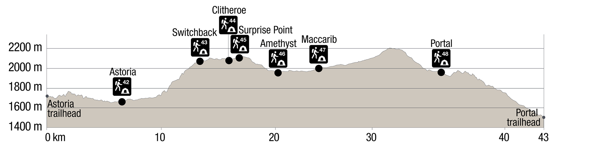
Text version
- The elevation profile shows the trail beginning at the Astoria trailhead at 1730 m
- Gradual descent over 7.1 km to Astoria Campground (1690 m)
- Gentle climb for about 3 km, then more steeply to Switchback Campground at km 13.6 (2067 m).
- No significant elevation changes over the next 3.3 km to Clitheroe Campground (2080m)
- Beyond Clitheroe Campground, Surprise Point Campground is 2.2 km (1978 m) and Amethyst Campground is 3.2 km (1985 m)
- From Amethyst campground, Maccarib Campground is 3.4 km (2012 m)
- Trail ascends for 7.1 km to 2205m at Maccarib pass, then descend 3.8 km to Portal Campground (1979 m)
- The 8.7 km to the Portal Trailhead (1480 m) is mainly a descent, except for a 75 m ascent shortly beyond the campground
Campground information
| Campground | Elevation | Description | # of sites | Toilet type | Food storage | UTM |
|---|---|---|---|---|---|---|
| Astoria #42 |
1690 m | This forested campground sits on a ridge high above the Astoria River. | 4 | Throne | Lockers | 11U 422681 5837524 |
| Switchback #43 | 2067 m | A somewhat forested campground, which still has great views of the surrounding mountains. | 8 | Throne | Lockers | 11U 418802 5837175 |
| Clitheroe #44 |
2080 m | This forested campground offers views of the Ramparts Mountain Range. It can be used as a base camp to explore the Eremite Valley. | 8 | Barrel | Lockers | 11U 416199 5838929 |
| Surprise Point #45 |
1978 m | This campground close to the base of the Ramparts Mountain Range has stunning views. It is also a great base for day hiking into the Eremite Valley. | 4 | Barrel | Lockers | 11U 415545 5837389 |
| Amethyst #46 |
1985 m | Located close to Amethyst Lake with spectacular views of the Ramparts Mountain Range, this is the most centrally located and most popular campground in the valley. | 8 | Barrel | Lockers | 11U 414457 5840086 |
| Maccarib #47 |
2012 m | This campground is perched nicely at treeline with great views of the valley. | 8 | Barrel | Lockers | 11U 414561 5842975 |
| Portal #48 |
1979 m | A nice campground in an open forest next to a creek. | 4 | Barrel | Lockers | 11U 421730 5843293 |
How to get there

Directions to Portal trailhead
Portal Creek is on Marmot Road (16 km from Jasper). This trailhead is accessible year-round.
From Jasper
- Take the Icefields Parkway towards Banff, and turn right immediately after the park gate onto Wabasso Road (Hwy 93A).
- Continue along 93A for 2.4 km, and turn right onto Marmot Road.
- The trailhead is on your left at km 12 of the road, marked by a hiker sign.
From Banff and Lake Louise
- Follow the Icefields Parkway north towards Jasper.
- Turn left at the junction for Highway 93A / Athabasca Falls, 200 km north of Lake Louise.
- Continue along 93A for 21.5 km, and turn left onto Marmot Road.
- The trailhead is on your left at km 12 of the road, marked by a hiker sign.
Directions to Astoria trailhead
Cavell Road (29 km from Jasper): The road is typically open to vehicles from late-June to October 15. The Cavell Road is closed to all use from November 1 through May 15 for caribou conservation.
From Jasper
- Take the Icefields Parkway towards Banff, and turn right immediately after the park gate, onto Highway 93A.
- Continue along 93A for 5.2 km, and turn right onto the Edith Cavell Road.
- The trailhead is across from Hostelling International’s (HI) Edith Cavell Hostel, at km 12 of the road.
From Banff and Lake Louise
- Follow the Icefields Parkway north towards Jasper.
- Turn left at the junction for Highway 93A / Athabasca Falls, 200 km north of Lake Louise.
- Continue for 18.8 km, and turn left onto the Edith Cavell Road.
- The trailhead is across from Hostelling International’s (HI) Edith Cavell Hostel, at km 12 of the road.
Are you prepared?
Safety is your responsibility
Refer to the Jasper National Park Backcountry Planning Guide:
- descriptions of trail types and campground facilities;
- equipment checklists;
- responsible camping practices;
- safety information.
Before heading out, check trail, weather and road conditions at: parks.canada.ca/jaspertrails.
Maps
| NTS | National Geographic | Gem Trek |
|---|---|---|
| Jasper 83D/16 Amethyst Lakes 83D/9 |
Jasper South | Jasper and Maligne Lake |
Permits
A backcountry camping permit is mandatory for all overnight trips and can be obtained online at reservation.pc.gc.ca or by calling 1-877-737-3783.
- Date modified :