
Avalanche information
Waterton Lakes National Park
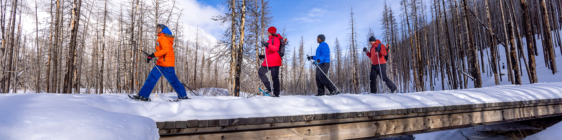
Much of Waterton Lakes National Park and most of its trails are avalanche terrain. Backcountry travellers are responsible for their own decisions and safety.
Consult the avalanche terrain ratings below to help determine if your planned objective is suitable for you. Use these ratings along with the Avalanche Bulletin (issued from December 1 to April 15) to make an informed decision.
If your trip is in avalanche terrain, you will need:
- Training to recognizing avalanche terrain and understand the avalanche hazard.
- Avalanche rescue equipment: avalanche transceiver, probe and shovel combined with companion rescue training.
Visitors should be aware that periods of avalanche hazard may still exist in Waterton Lakes National Park outside of the regular winter season.
Be aware that there are specific travel restrictions that apply to custodial groups (those which include minors without their legal guardians) between November 15 and April 30.
Post wildfire avalanche hazard
Treat burnt forests like open alpine slopes. Increased wind effect and slab formation, and continuous weak layers in the trees are to be expected. Larger, more frequent avalanches in existing paths and new avalanche paths are possible in burned areas.
Avalanche terrain ratings for trails in Waterton Lakes National Park
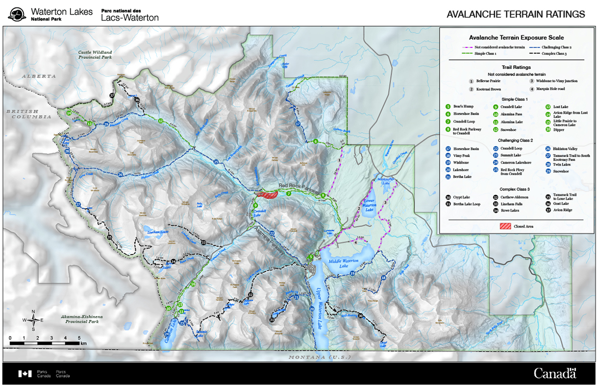
Avalanche terrain ratings - Text version
Trail ratings
- Not considered avalanche terrain
- Bellevue
- Kootenai Brown
- Wishbone to Vimy junction
- Marquis Hole Road
- Simple Class 1
- Horseshoe Basin
- Crandell Loop
- Red Rock Parkway to Crandell
- Crandell Lake
- Akamina Parkway to Rowe
- Akamina Pass
- Akamina Lake
- Snowshoe
- Lost Lake
- Avion Ridge from Lone Lake
- Challenging Class 2
- Horseshoe Basin
- Vimy Peak
- Wishbone
- Lakeshore
- Bertha Lake
- Crandell Loop
- Summit Lake
- Cameron Lakeshore
- Akamina Parkway from Rowe
- Red Rock Parkway from Crandell
- Blakiston Valley
- Tamarack trail to South Kootenay Pass
- Twin Lakes
- Snowshoe
- Complex Class 3
- Crypt Lake
- Bertha Lake Loop
- Carthew-Alderson
- Lineham Falls
- Rowe Lakes
- Tamarack Trail to Lone Lake
- Goat Lake
- Avion Ridge
Avalanche Terrain Ratings for Waterton Lakes National Park
Not considered avalanche terrain
- Bellevue trail
- Blakiston Fan horse trails
- Golf course trails
- Wishbone trail to Vimy Peak junction
Simple - 1
- Akamina Parkway: Entrance gate to Rowe Lakes trailhead
- Akamina Pass
- Akamina Pass to Forum Lake
- Bear's Hump trail
- Cameron Lake ski trail to the lake
- Crandell Lake
- Crandell Loop trail along Red Rock Parkway
- Dipper trail
- Horseshoe Basin trail - Bison Paddock to Galwey Creek
- Linnet Lake trail
- Park Line trail
- Red Rock Parkway
- Red Rock Canyon to Goat Lake junction
- Snowshoe Cabin to Castle Divide and Lost Lake
- Yarrow to Oil Basin patrol trail
Challenging - 2
- Akamina Parkway: Rowe Lakes trailhead to Cameron Lake
- Akamina Pass to Wall Lake
- Bertha Lake trail
- Blakiston Valley trail to South Kootenay Pass junction
- Boundary trail
- Cameron Lakeshore trail
- Crandell Loop trail along Akamina Parkway
- Forum Ridge
- Goat Lake junction to Snowshoe Cabin
- Horseshoe Basin trail from Trail Creek to Oil Basin
- Lakeshore trail
- Snowshoe Cabin to Twin Lakes and Sage Pass
- South Kootenay Pass trail
- South Kootenay Pass junction to Lone Lake
- Summit Knob to Cameron Lake
- Summit Knob to Boundary Creek
- Summit Lake trail from Cameron Lake
- Twin Lakes to South Kootenay Pass junction
- Vimy Peak trail
- Wishbone trail from Vimy junction to Crypt landing
Complex - 3
- Akamina Lake chutes (The Fingers)
- Carthew-Alderson trail
- Bertha Lake Loop trail
- Crypt Lake trail
- Goat Lake trail, including Avion Ridge to Castle Divide
- Lineham Falls
- Rowe Lakes
- Rowe Basin to Lone Lake
- Rowe Bowl / Peak (CV 13)
Avalanche Terrain Exposure Scale (ATES)
| Description | Class | Terrain criteria | |
|---|---|---|---|
| Simple | 1 | Exposure to low angle or primarily forested terrain. Some forest openings may involve the run-out zones of infrequent avalanches. Many options to reduce or eliminate exposure. No glacier travel. | |
| Challenging | 2 | Exposure to well defined avalanche paths, starting zones or terrain traps; options exist to reduce or eliminate exposure with careful route finding. Glacier travel is straightforward but crevasse hazards may exist. | |
| Complex | 3 | Exposure to multiple overlapping avalanche paths or large expanses of steep, open terrain; multiple avalanche starting zones and terrain traps below; minimal options to reduce exposure. Complicated glacier travel with extensive crevasse bands or icefalls. |
How much experience do I need for these trips?
Simple - class 1
Terrain requires common sense, proper equipment, first aid skills, and the discipline to respect avalanche warnings. Simple terrain is usually low avalanche risk, ideal for novices gaining backcountry experience. These trips may not be entirely free from avalanche hazards, and on days when the Backcountry Avalanche Advisory is rated ‘Poor’, you may want to re-think any backcountry travel that has exposure to avalanches – stick to groomed x-country trials or within the boundaries of a ski resort.
Challenging - class 2
Terrain requires skills to recognize and avoid avalanche prone terrain – big slopes exist on these trips. You must also know how to understand the Public Avalanche Bulletin, perform avalanche self rescue, basic first aid, and be confident in your route finding skills. You should take an Avalanche Skills Training Level 1 course (AST 1) prior to travelling in this type of terrain. If you are unsure of your own, or your group’s ability to navigate through avalanche terrain – consider hiring a professional ACMG certified guide.
Complex - class 3
Terrain demands a strong group with years of critical decision making experience in avalanche terrain. There can be no safe options on these trips, forcing exposure to big slopes. A recommended minimum is that you or someone in your group should have taken an Avalanche Skills Training Level 2 course (AST 2) and have several years of back country experience. Be prepared! Check the Public Avalanche Bulletin regularly, and ensure that everyone in your group is up for the task and aware of the risk. This is serious country – not a place to consider unless you are confident in the skills of your group. If you are uncertain – consider hiring a professional, ACMG certified guide.
Know before you go
Will your group be travelling in avalanche terrain?
- Does your group have the skills, knowledge and training to travel in avalanche terrain?
- Are you carrying transceivers, shovels and probes?
- Can you self-rescue? Do you have a plan?
- Do you know the emergency number?
- Have you checked the current avalanche bulletin and weather forecast?
- Have you checked out with someone?
- Do you have any other route options?
Phone numbers
- Emergency number with cell phone: 911 (state that you are in Waterton Lakes National Park)
- Backcountry emergency number with satellite phone: 1-403-762-4506
Remember, cell phones are not always reliable in the backcountry.
Related links
- Date modified :