
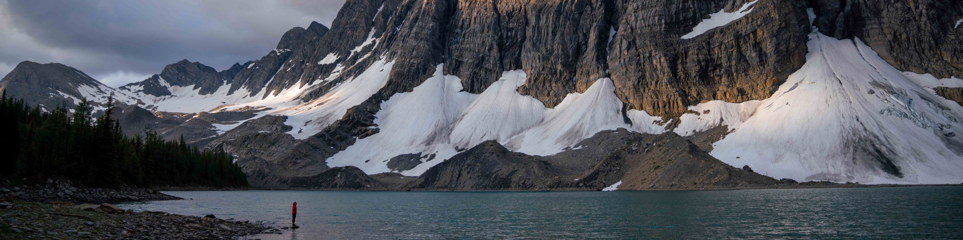
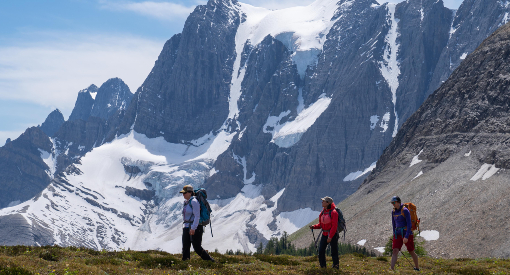
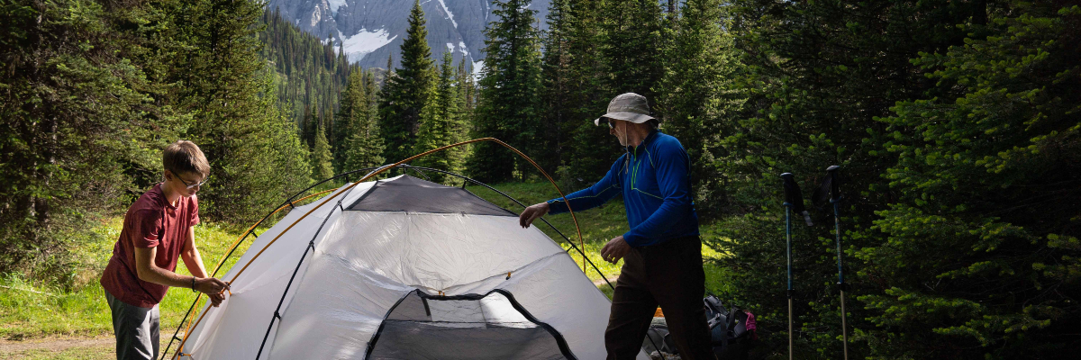
Backpacking
Kootenay National Park
Kootenay National Park offers extensive backcountry experiences to visitors looking to explore further into the park. Hiking and camping in the backcountry allows you to experience the beauty and wilderness of the park.
This section of the website is designed to help you plan a safe and enjoyable visit to Kootenay National Park’s backcountry, while respecting sensitive ecosystems.
A backcountry permit is mandatory for anyone planning an overnight trip into the backcountry of Kootenay National Park. Campers must have a copy of their permit (paper or a screen shot) and present it to Parks Canada staff when requested.
Advance reservations are necessary to secure your campsite at most locations for July, August and September. A non-refundable reservation fee applies to all bookings.
Visitors also require a National Park Pass to enter Kootenay National Park.
Backcountry permit bookings:
- Reservation launch: Monday, January 29 2024 at 8:00 am MT
- Prepare for launch day
Reserve:
- Online 24/7
- By calling: 1-877-RESERVE (1-877-737-3783)
Backpacking in Kootenay National Park
When to go
The main hiking season in Kootenay National Park is from June to October. Until late June, many mountain passes and trails at higher elevations remain snowbound and may be impassable. July and August are the prime backcountry hiking months but even in summer, snow is common at higher elevations. September is generally drier than July and August, although temperatures are lower and there is a greater chance of snowfall.
What to bring
This is a list of suggested items to pack, which you can adjust to suit your personal preferences. Mountain weather is unpredictable, be prepared for winter conditions at any time of the year. This equipment list does not account for the special knowledge and equipment required to travel in avalanche terrain.
Shelter
- tent with waterproof fly and groundsheet
- sleeping pad
- sleeping bag
- repair kit
Clothing
- hiking boots with ankle support and good soles
- sandals or runners for fording streams and at camp
- socks and underwear
- extra socks
- pants and/or shorts
- short and long-sleeved shirt
- base-layer (long underwear)
- insulating outer layer (fleece, down or synthetic down jacket)
- waterproof rainwear – jacket and pants/gaiters
- winter hat and gloves
- sun hat or baseball cap
Dry clothes go a long way to making you feel comfortable. Pack light but bring something dry to change into when you reach camp. Keep clothing dry by placing items in a waterproof bag in your backpack.
Food and cooking
- water treatment or filter (Drinking Water in the Great Canadian Outdoors)
- water bottle or camelback, 1L minimum
- food, including enough for an extra day
- stove and fuel, with waterproof matches or a lighter. Campfires are not permitted anywhere in the backcountry.
- cooking and eating utensils
- garbage bags to pack out all food and personal trash
- sturdy food sack (or backpack) for hanging
For your safety and that of wildlife, your food must be securely stored in the wildlife-proof food locker or suspended from the food storage cables in your campground. Ensure you have a sturdy food sack that will stand up to wind and the elements. Do not leave food in lockers or storage cables when you depart. To stay safe and protect wilderness, manage your food, food smells and garbage.
Essentials
- backcountry permit and park pass
- bear spray
- sunglasses & sunscreen
- headlamp or flashlight
- pocketknife or multi-tool
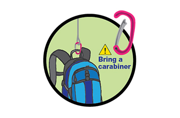
- rope and carabiner (approx 8 m)
- trip plan (left with a reliable person)
- insect repellent
- topographic map and trip description: guidebooks and topographic maps are available at visitor centres and retail outlets in Yoho, Golden and Lake Louise.
- GPS/compass
- first aid and blister kits
- whistle
- extra batteries for your devices
- compact emergency kit (i.e. waterproof matches or lighter, flashlight or headlamp and extra batteries, signaling device such as a whistle or mirror, emergency blanket, pencil and paper)
- basic toiletries, toilet paper and hand sanitizer
It is recommended that you carry bear spray and know how to use it.
Other items to consider
- satellite communication device (ie. SPOT, InReach, Zoleo, etc.), personal locator beacon (PLB) or satellite phone
- camera with charged batteries and an empty memory card
- notebook and pencil
- deck of cards
- fishing permit
- binoculars
- biodegradable soap
- camp towel
- watch or alarm clock
- candle
- trowel
- altimeter
- field guide(s)
- trekking poles
- change of clothes and sandals for the drive home
Safety
Safety is your responsibility. There are always hazards associated with outdoor recreation. When planning a backcountry trip to Kootenay National Park, select a trip which best suits your group’s abilities, experience, interests, equipment and the time you have available. Caution and self-reliance are essential.
- Plan ahead
- Check the weather forecast, current trail conditions, warnings and closures or visit a Parks Canada visitor centre.
- Mountain weather changes quickly and it can snow any month of the year. Ensure that you have adequate food, water, clothing and equipment for your trip. Don’t forget essentials including toilet paper.
- Know your physical limits. Always choose a trip suitable for the least experienced member in your group.
- At least one person in your party should be able to recognize natural hazards and have training in wilderness first aid
- Parks Canada does not maintain or patrol winter trails in Kootenay National Park. Some hiking trails are suitable for skiing and snowshoeing, but the park is a natural area and travel is at your own risk.
- Tell a reliable person where you are going, when you will be back, and who to call if you do not return: Parks Canada Dispatch – 403-762-1470.
- Check equipment
- Conditions can change from minute to minute and place to place. Generally, the higher you go, the colder and windier it gets. Ultraviolet radiation is also stronger at higher elevations. A toque, warm jacket and sunscreen may all be required on any given day during the summer.
- Study trip descriptions, maps and expected hazards before heading out. Guidebooks and topographic maps are available at visitor centres and retail outlets in Radium Hot Springs and Lake Louise.
- Carry a first aid kit, bear spray and a satellite emergency communication device like SpotX, inReach or Zoleo, and know how to use them.
- Prepare gear and supplies for at least one day longer than your planned trip. See a complete list of suggested equipment in the what to bring section below.
- Be alert
- Be alert for wildlife at all times. Avoid wearing earbuds or headphones. Learn how to travel safely in bear country.
- Ticks, which could carry Lyme disease, may be present in the park. It is important to check yourself and your pet after hiking.
- Boil, filter or chemically treat all water before drinking. Surface water may be contaminated and unsafe for drinking.
- In case of EMERGENCY, call 911 or satellite phone: 403-762-4506. Cell phone coverage is not reliable throughout the national park.
Snowy Trails
Snow can remain on some trails well into the summer. When trails are snow covered, route-finding can be difficult and travel through deep or hard snow and ice can be unsafe. Be prepared and check trail conditions before heading out.
Seasonal Avalanche Risk

Avalanches are possible from early winter to early summer. Trails above tree line (2,000 m) may be exposed to avalanche hazard at any time of the year. Travel only in terrain appropriate for your group’s experience, abilities and equipment. Training and experience can help you recognize and avoid dangerous avalanche conditions.
For more information on avalanche conditions, visit a Parks Canada visitor centre or check the Mountain Safety section.
Protecting the Park
Humans have an impact in the backcountry. Vegetation is fragile, especially at higher elevations, wildlife are not habituated to people, and backcountry users are seeking quiet and solitude.
Park management regulations and guidelines are in place to minimize our impact on the wilderness and each other.
- Backcountry Permit
- Climbing, mountaineering and glacier travel
- Camping restrictions
- A maximum of 4 people and 1 tent are allowed per tent pad/site.
- The length of stay for any campground cannot be more than 3 consecutive nights.
- The maximum group size for a reservation is 10 people and 5 tents.
- Cooking and campfires
- Washing
- Pack out garbage
- Food storage
- Properly dispose of human waste
- Pets
- Ensure your pet is on a leash and under physical control at all times.
- Pick up and dispose of your pet’s waste in a garbage bin.
- Consider leaving your dog at home when camping or hiking in the backcountry.
- Fishing
- Stay on trails
- Share the trail
- Collecting natural or cultural objects
- Firearms are prohibited
A backcountry permit is required when traveling in the backcountry. Visit our backcountry reservations page for more info. Individuals must have a copy of their backcountry permit (paper or a screen shot) and present it to Parks Canada staff when requested.
Mountaineers are permitted to bivouac on specified routes, and may do so in non-vegetated areas only. For detailed information on bivouacking and to find out what routes are permitted, please visit the Parks Canada visitor centre in the Village of Radium Hot Springs or call 250-347-9505.
Camp in designated campgrounds as indicated on your reservation and use the tent pads provided to minimize impact on vegetation.
Random camping is not permitted in Kootenay National Park.
All backcountry travellers should carry a portable fuel or propane stove for cooking. Cook and eat in the designated cooking area.
Campfires are not permitted anywhere in the Kootenay National Park backcountry.
Wash well away from any lakes, streams or river, and keep the use of soap to a minimum. Even biodegradable soap are pollutants. Strain out those last bits of food waste and pack them out. Disperse grey water on land, a good distance from water sources and campsites.
If you pack it in—pack it out. Littering is against the law and hazardous to wildlife. Do not dispose of garbage in outhouses or leave it in food lockers.
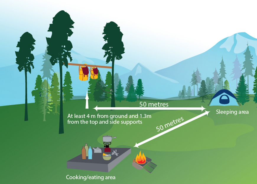
To avoid attracting bears and other wildlife to your campsite, all food, garbage, toiletries and cooking equipment must be stored in the wildlife-proof food storage lockers or on bear poles provided at designated campgrounds. For areas where bivouacking is permitted, bring a rope to hang your food downwind of your campsite (see illustration), or a bear-proof canister for areas where trees are not suitable for food storage.
For more information, contact a Parks Canada visitor centre. Remove all garbage, food and belongings at the end of your stay.
Use the outhouses provided. If there are no outhouses nearby, select a spot away from trails, campsites and at least 70 m away from water sources. Dig a hole 12 to 16 cm deep to reach the dark-coloured soil layer. When refilling the hole with soil, do not pack it down. Pack out toilet paper and used feminine hygiene products.
Pets are welcome in the backcountry but must be leashed at all times. To a wild animal, your pet is potentially a predator or prey. Wildlife may flee, endangering themselves or their young. Alternatively, they may respond aggressively, endangering you and your pet.
To prevent unsafe situations:
To fish in Yoho National Park, everyone aged 16 or older is required to have a National Park Fishing Permit. Children under 16 do not require a permit but must be accompanied by a permit holder. These permits can be purchased at a Parks Canada visitor centre. Provincial fishing licenses are not valid in the national parks. The possession limit for all fish caught in Yoho or Kootenay national parks is zero. See the Fishing Regulations page for more information.
Clean Drain Dry all water-related gear and complete a Self-certification Permit before recreating in any body of water in Banff, Yoho, or Kootenay national parks.
Short-cutting between trail switchbacks damages both the soil and plant life, making the area susceptible to further damage by erosion. Stay on designated trails at all times.
Backcountry trails and campsites may be shared by hikers, trail runners, horse parties and mountain bikers. Respect for others can go a long way toward reducing conflicts. Make noise if you are travelling quickly or silently, move off the trail to allow larger parties to pass, and avoid sudden movement around horses as they may spook.
Leave all rocks, fossils, horns, antlers, wildflowers, berries, mushrooms, nests and other natural or historic objects where they are for others to enjoy. It is unlawful to remove, deface, damage or destroy any natural or cultural resources within the national parks. Visit leavenotrace.ca for information on low-impact backcountry travel.
Firearms, including pellet guns, bear bangers, bows, slingshots and similar, are prohibited in national parks. Parks Canada recommends carrying bear spray and knowing how to use it for protection for protection from wildlife.
Wildlife and People
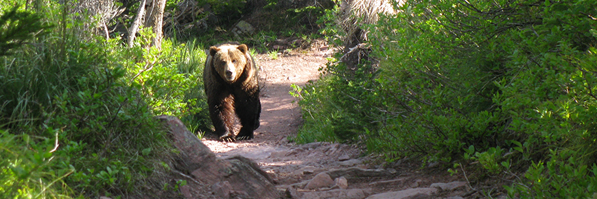
Kootenay National Park is home to wildlife including elk, wolves, cougars, grizzly bears and black bears. To successfully raise their young and sustain a healthy population, wildlife need access to as much quality habitat with as few human surprises as possible. Be aware of possible encounters with wildlife in all areas of the park, including paved trails and roads.
All wild animals can be dangerous regardless of their size. Any animal can become aggressive if it feels threatened.
Always carry bear spray, ensure it is accessible, and know how to use it. Bear spray is available at the Parks Canada Visitor Centre and some retail outlets in Radium Hot Springs and Lake Louise.
Make noise. Being quiet puts you at risk for sudden wildlife encounters. Be alert through shrubby areas, near running water and when approaching blind corners. Travel in tight groups and always be aware of your surroundings.
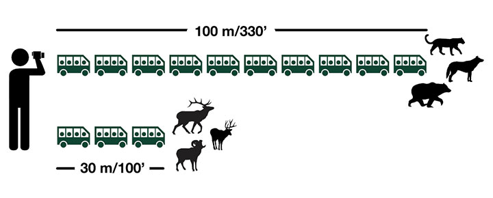
Do not approach wildlife. Stay 30m (3 bus lengths) away from elk, deer, and moose. Stay 100m (10 bus lengths) away from bears and other carnivores. This is a park regulation. Offenders may be charged.
If you are close enough to take a selfie, you are too close.
If an animal approaches you, you are responsible for backing away. Be alert for any animal warning signs that indicate you are too close. Do not chase, follow, pursue, stalk, entice, or otherwise harass wildlife.
Parks Canada staff may need to manage wildlife for the safety of the animals and park visitors. This will take priority over wildlife viewing and photography.Your cooperation is mandatory.
Report bear, cougar, wolf and coyote incidents and encounters to Parks Canada Dispatch when possible and safe to do so: 403-762-1470.
Keep pets on leash and under physical control at all times.
Leave your drone at home. Drones disturb wildlife and other park visitor. Drones are not permitted in the national park.
More information:
.jpg)
Where to go
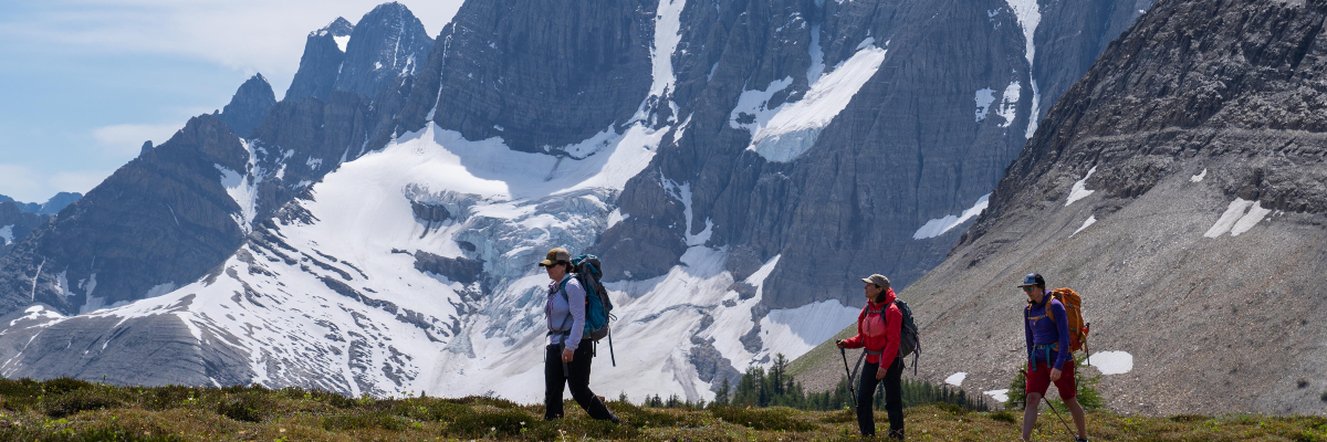
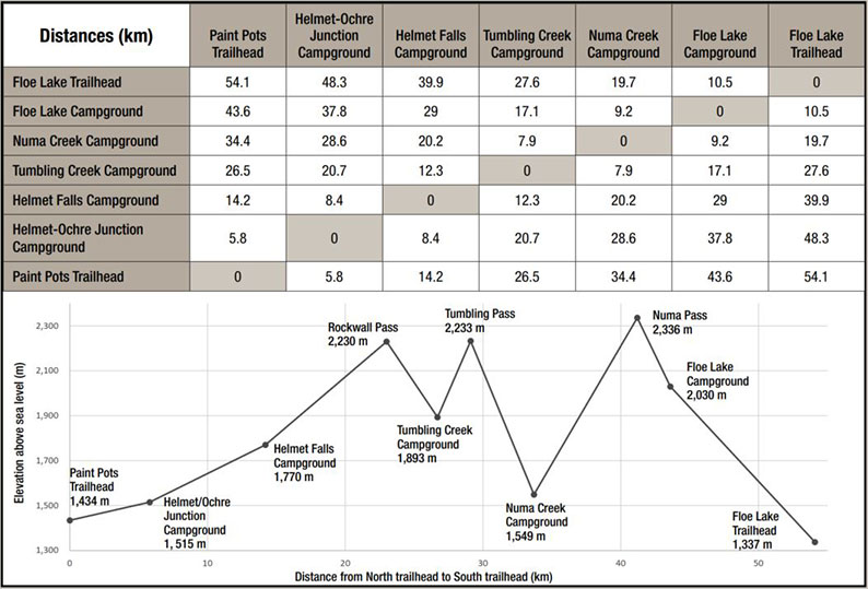
Kootenay National Park’s most popular backpacking is along the Rockwall trail. Journey in either direction and link Helmet Falls, Tumbling Creek, Numa Creek and Floe Lake. Campgrounds for this popular backcountry adventure book out early in the season and planning your route in advance is key. Strong hikers may access neighbouring campgrounds in Banff National Park via the Verdant Creek trail.
In more popular areas of Kootenay’s backcountry, you will find maintained hiking trails and designated campsites with outhouses, tent pads, food storage cables or food lockers and picnic tables. More remote areas of the park provide a greater opportunity for solitude, although trails may not be regularly maintained and hikers must be self-reliant. Route finding and navigation skills are required and hikers should be prepared to safely ford streams. Pre-trip planning and preparedness are essential for travel in the backcountry.
Map: Downloadable map of Kootenay’s backcountry trails and campground locations
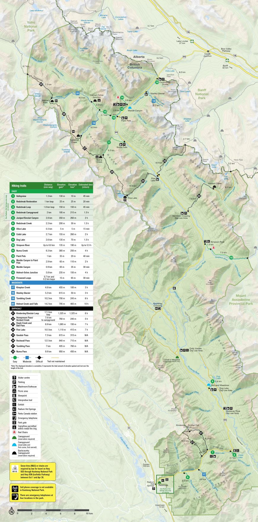
Trail Ratings
|
Easy |
|
|
Moderate |
|
|
|
|
| Estimated time to complete these trails ranges depending on trail distances, fitness levels, weather and trail conditions. | |
| Trail | Distance (one way) |
Estimated time (return) | Elevation gain* | Elevation loss* |
|---|---|---|---|---|
 Helmet - Ochre Junction Helmet - Ochre Junction |
5.8 km | 2 days | 235 m | 150 m |
 Tumbling Creek Tumbling Creek |
10.2 km | 2 days | 700 m | 245 m |
| Helmet Creek and Falls |
14.2 km | 2-3 days | 795 m | 465 m |
 Numa Creek Numa Creek |
6.3 km | 2 days | 385 m | 250 m |
| Tumbling - Helmet - Ochre Loop |
36.9 km loop | 2-3 days | 1,885 m | 1,885 m |
| Tumbling - Floe |
37.7 km | 2-3 days | 2,470 m | 2,565 m |
| The Rockwall |
54.1 km | 3-5 days | 3,405 m | 3,500 m |
| Honeymoon Pass and Verdant Creek
|
16.7 km | 2 days | 1,285 m | 470 m |
*Note: On most hiking trails you will gain and lose elevation before you reach your destination. Elevation gain represents all the up and elevation loss all the down you will experience on a one-way hike.
 Helmet-Ochre Junction
This day hike leads to the Helmet / Ochre Junction backcountry campground. It is the northernmost access point for the popular Rockwall multiday backpacking route.
Length (one way): 5.8 km
Estimated time (return): 2 days
Elevation gain: 235 m | Elevation loss: 150 m
Trailhead: Paint Pots parking lot, 84 km east of Radium Hot Springs.
Habitat: Forested trail with lush ground cover leading to a river.
Description: A good backpacking destination for beginners through lush forest. Alternatively, a 4-hour day hike.
 Tumbling Creek
This trail leads to the Tumbling Creek backcountry campground. It is one of the northernmost access points to the popular Rockwall multiday backpacking route. The initial portion of the trail is shared with the Helmet / Ochre Junction trail.
Length (one-way): 10.2 km
Estimated time (return): 2 days (round-trip)
Elevation gain: 700 m | Elevation loss: 245 m
Trailhead: Paint Pots parking lot 84 km east of Radium Hot Springs.
Habitat: Forested trail with lush ground cover opening into prominent avalanche slopes.
Description: Hike alongside fast, rushing water and stop for a photo at Tumbling Falls.
Helmet Creek and Falls
This trail leads to the Helmet Falls backcountry campground. It is the northernmost access point to the popular Rockwall multiday backpacking route. The initial portion of the trail is shared with the Helmet / Ochre Junction trail.
Length (one way): 14.2 km
Estimated time (return): 2-3 days (round-trip)
Elevation gain: 795 m | Elevation loss: 465 m
Trailhead: Paint Pots parking lot 84 km east of Radium Hot Springs.
Habitat: Forested trail with lush ground cover opening into prominent avalanche slopes.
Description: Follow the trail through lush vegetation and emerge near the base of Helmet Falls. At 300 m high, this waterfall is definitely worth a visit.
 Numa Creek
This trail leads to the Numa Creek backcountry campground and is a middle access point for the popular Rockwall multiday backpacking route.
Length (one way): 6.3 km
Estimated time (return): 2 days
Elevation gain: 385 m | Elevation loss: 250 m
Trailhead: Numa Falls parking lot, 80 km east of Radium Hot Springs.
Habitat: A forested, creekside trail opening into prominent avalanche paths.
Description: A shaded creekside trail. Good backpacking destination for beginners. Alternatively, a 4-hour day hike.
Note: This trail gets heavily impacted by avalanche debris year-round and may be closed. Check the latest trail report for updates.
Tumbling - Helmet - Ochre Loop
This trail takes in three backcountry campgrounds on the northern portion of the popular Rockwall Trail, multi-day backpacking route.
Length (one way): 36.9 km loop
Estimated time (return): 2-3 days
Elevation gain: 1,885 m | Elevation loss: 1,885m
Trailhead: Paint Pots parking lot, 84 km east of Radium Hot Springs. Entry and exit from Paint Pots parking lot. No shuttle required.
Habitat: Forested trails opening into high, alpine meadows.
Description: An abridged loop version of the Rockwall Trail with its famous high meadows.
Tumbling - Floe
This trail takes in three backcountry campgrounds on the southern portion of the popular Rockwall Trail, multi-day backpacking route.
Length (one way): 37.7 km
Estimated time (return): 2-3 days
Elevation gain: 2,470 m | Elevation loss: 2,565 m
Trailhead: Paint Pots parking lot, 84 km east of Radium Hot Springs OR Floe Lake parking lot, 72 km east of Radium Hot Springs. Entry/exit via Tumbling Creek and Floe Lake. Shuttle required.
Habitat: Forested trails opening into high, alpine meadows.
Description: An abridged version of the Rockwall Trail with its famous high meadows.
The Rockwall
This route takes in a maximum of five backcountry campgrounds.
Length (one way): 54.1 km
Estimated time (return): 3-5 days
Elevation gain: 3,405 m | Elevation loss: 3,500 m
Trailhead: Multiple trailheads, from north to south: Paint Pots parking lot, 84 km east of Radium Hot Springs; Numa Falls parking lot 80 km east of Radium Hot Springs; Floe Lake parking lot, 72 km east of Radium Hot Springs. Shuttle required.
Habitat: Forested trails, multiple alpine passes, creeks, waterfalls, meadows, large lake.
Description: One of the finest backpacking routes in the Canadian Rockies, featuring high passes and the famous “Rockwall”.
Note: Numa Creek Trail gets heavily impacted by avalanche debris year-round and may be closed. Check the latest trail report for updates.
The Rockwall
The Rockwall Trail is a 54 km (34 mile) superlative-laden feast, traversing three alpine passes through subalpine meadows and past impressive hanging glaciers. The trail’s defining feature is a single, massive limestone cliff, towering in some locations more than 900 m (2,953 feet) above the trail below.
There are four access points to the Rockwall Trail along Highway 93 South:
- Helmet Creek Trail, access via Paint Pots trailhead
- Tumbling Creek Trail, access via Paint Pots trailhead
- Numa Creek Trail, access via Numa Falls trailhead
- Floe Lake Trail, access via Floe Lake trailhead
Recommended time of year to hike this trail: Mid-July to early October.
Note: The higher sections of the trail are snowbound until early to mid-July. Parks Canada does not book sites at Floe Lake campground until July 10. Autumn snowfalls may make hiking difficult in late September/October.
Honeymoon Pass and Verdant Creek
This route leads to Verdant Creek backcountry campground and the Egypt Lake area of Banff National Park.
Length (one way): 16.7 km to park boundary
Estimated time (return): 2 days
Elevation gain: 1,285 m | Elevation loss: 470 m
Trailhead: Vermilion Crossing parking lot 64 km east of Radium Hot Springs.
Habitat: Thickly forested, rough trail with prominent avalanche slopes. Watch for bears.
Description: Fireweed flowers and burnt trees offer striking contrasts on this rough trail for skilled backpackers. Backcountry campground at 7.6 km. Access to trails in Banff National Park.
Note: The trail past the campground has been heavily impacted by 2017 wildfires, leaving long sections of trail undefined and covered by deadfall. Advanced routefinding skills and river crossings required.
Where to stay
Backcountry campgrounds
There are six backcountry campgrounds in Kootenay National Park. Five are located along the Rockwall Trail, while the sixth is on the Verdant Creek Trail.
Campers must camp in designated campgrounds as indicated on your backcountry permit and use the tent pads provided to minimize impact on vegetation. Random camping is not permitted anywhere in Kootenay National Park. The following applies to all backcountry campgrounds;
- A maximum of 4 people and 1 tent are allowed per tent pad/site.
- The maximum length of stay for any campground is 3 consecutive nights.
- The maximum group size for a reservation is 10 people and 5 tents.
- Campers must have a copy of their backcountry permit (paper or a screen shot) and present it to Parks Canada staff when requested.
- Fires are not permitted in any backcountry campground in Kootenay National Park.
All campgrounds are equipped with:
- tent pads
- dry toilets
- communal picnic tables
- food storage cables or food lockers
Random Camping
- To preserve the ecological integrity of the park, random camping is not allowed in Kootenay National Park throughout the summer months (May to October).
- In winter, random camping is allowed by permit only in designated backcountry locations. A backcountry permit for random camping can be obtained in person at the Parks Canada visitor center in Lake Louise, or by calling 403-522-1264.
Beyond park boundaries
Continuing beyond park boundaries? Find out more about backcountry opportunities beyond Kootenay National Park.
Banff National Park
Yoho National Park
Jasper National Park
B.C. Provincial Parks
- Date modified :