
Getting here
Gros Morne National Park
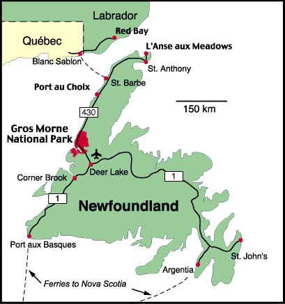 Map of the island of Newfoundland
© Parks Canada
Newfoundland and Labrador is the easternmost province in Canada. Gros Morne National Park is located on the west coast of the island of Newfoundland. The island is accessible by scheduled airline services that connect with most major centres in North America and northern Europe. Car and bus access is via the Marine Atlantic ferry service from Nova Scotia.
Air
Deer Lake Regional Airport (YDF) is 35 km from the southern park boundary. The airport is served by direct daily flights from Montreal (May–October), Toronto, Halifax, and St. John’s. Deer Lake airport serves the west coast of Newfoundland, while St. John’s International Airport (YYT) serves the east coast of Newfoundland. Intra-provincial flights are available between Deer Lake and St. John’s. Several major car rental agencies operate out of the Deer Lake airport. There are bus services that can also provide transportation from the town of Deer Lake to Gros Morne.
Car & Ferry
If driving from the Canadian mainland, the shortest way to Gros Morne is via the ferry service between North Sydney, Nova Scotia, and Port aux Basques, Newfoundland. It is 300 km from Port aux Basques to the southern park boundary, about a four hour drive.
Marine Atlantic operates ferries year-round between North Sydney, Nova Scotia, and Port aux Basques on Newfoundland’s southwest coast. Ferry service between North Sydney and Argentia, on Newfoundland’s east coast, is offered from mid-June to late September. The crossing time from North Sydney to Port aux Basques is approximately 6 hours, and 11 hours from North Sydney to Argentia.
For ferry reservations, which are strongly recommended, and the most up-to-date ferry schedules and fares, please visit the Marine Atlantic website.
In summer, a ferry links northern Newfoundland with southern Labrador. Visit the Labrador Marine websitefor more information.
Bus, Shuttles, & Taxis
Gros Morne and the nearby communities of Trout River, Woody Point, Rocky Harbour, Norris Point, and Cow Head are served by local bus service and taxi. Both shuttles connect with the cross-island bus service provided by DRL.
- Martin’s Transportation, 709-453-2207
- Pittman’s Taxi, 709-458-2486
| Red Bay | |||||||||||||||||||||||||||
|---|---|---|---|---|---|---|---|---|---|---|---|---|---|---|---|---|---|---|---|---|---|---|---|---|---|---|---|
| 258 | L’Anse aux Meadows | ||||||||||||||||||||||||||
| 197 | 228 | Port au Choix | |||||||||||||||||||||||||
| 347 | 323 | 111 | Cow Head | ||||||||||||||||||||||||
| 344 | 320 | 108 | 3 | Shallow Bay Campground | |||||||||||||||||||||||
| 356 | 332 | 120 | 8 | 12 | St. Pauls | ||||||||||||||||||||||
| 362 | 338 | 126 | 15 | 18 | 7 | Broom Point | |||||||||||||||||||||
| 369 | 345 | 133 | 21 | 25 | 13 | 6 | Western Brook Pond Trail | ||||||||||||||||||||
| 377 | 353 | 141 | 29 | 33 | 21 | 14 | 8 | Sally’s Cove | |||||||||||||||||||
| 384 | 360 | 148 | 36 | 40 | 28 | 22 | 15 | 7 | Green Point Campground | ||||||||||||||||||
| 394 | 370 | 158 | 46 | 50 | 38 | 31 | 25 | 17 | 10 | Lobster Cove Head Lighthouse | |||||||||||||||||
| 395 | 371 | 159 | 47 | 51 | 39 | 32 | 26 | 18 | 11 | 3 | Berry Hill Campground | ||||||||||||||||
| 396 | 372 | 160 | 49 | 52 | 40 | 34 | 27 | 19 | 12 | 1 | 5 | Rocky Harbour | |||||||||||||||
| 400 | 376 | 164 | 53 | 57 | 45 | 38 | 32 | 24 | 17 | 9 | 10 | 4 | Visitor Centre | ||||||||||||||
| 406 | 383 | 170 | 59 | 63 | 51 | 44 | 38 | 30 | 23 | 15 | 16 | 6 | 6 | Norris Point | |||||||||||||
| 403 | 379 | 167 | 56 | 59 | 48 | 41 | 35 | 27 | 19 | 12 | 13 | 7 | 3 | 9 | Gros Morne Mountain Trail | ||||||||||||
| 435 | 411 | 199 | 87 | 91 | 79 | 73 | 66 | 58 | 51 | 43 | 44 | 39 | 34 | 40 | 32 | Wiltondale | |||||||||||
| 452 | 428 | 216 | 104 | 108 | 96 | 89 | 83 | 75 | 68 | 60 | 61 | 56 | 51 | 57 | 48 | 17 | Lomond Campground | ||||||||||
| 469 | 445 | 233 | 122 | 125 | 114 | 107 | 101 | 93 | 85 | 78 | 79 | 73 | 69 | 75 | 66 | 34 | 21 | Woody Point (Discovery Center) | |||||||||
| 473 | 449 | 237 | 126 | 129 | 118 | 111 | 105 | 97 | 89 | 82 | 83 | 77 | 73 | 79 | 70 | 38 | 25 | 4 | Tablelands Trail | ||||||||
| 481 | 457 | 245 | 134 | 137 | 125 | 119 | 112 | 104 | 97 | 89 | 90 | 85 | 80 | 86 | 78 | 46 | 33 | 12 | 8 | Green Gardens Trail | |||||||
| 485 | 461 | 249 | 138 | 141 | 129 | 123 | 116 | 108 | 101 | 93 | 94 | 89 | 84 | 90 | 82 | 50 | 37 | 16 | 12 | 4 | Trout River | ||||||
| 467 | 443 | 231 | 120 | 123 | 111 | 105 | 98 | 90 | 83 | 72 | 76 | 71 | 67 | 73 | 64 | 32 | 49 | 66 | 70 | 78 | 82 | Deer Lake | |||||
- Date modified :