
Participate in the Coastie initiative
Coastie is a simple and easy way for Canadians to better protect coastlines!
The Coastie initiative is a new citizen science program led by the University of Windsor in collaboration with Parks Canada. Based on the CoastSnap program developed in Australia, the Coastie initiative uses photos that you take at participating sites across the country to help scientists monitor coastal change over time.
By taking a Coastie, you participate in community science!
How Coastie works
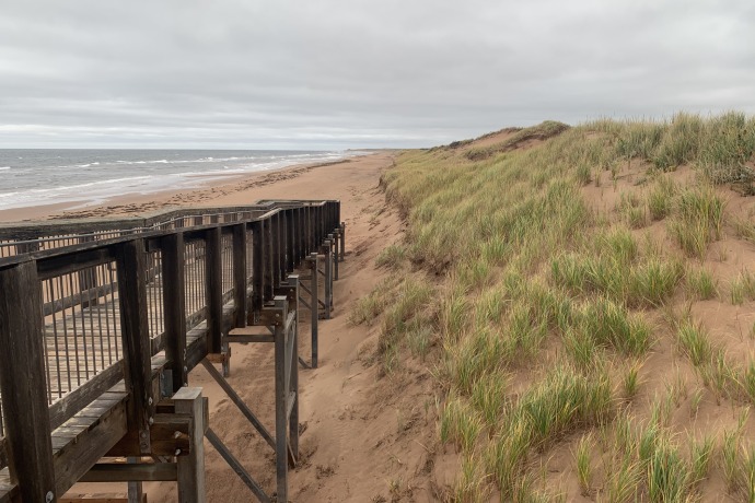
Coastie cradles are installed in specific locations at participating sites.
Take a Coastie
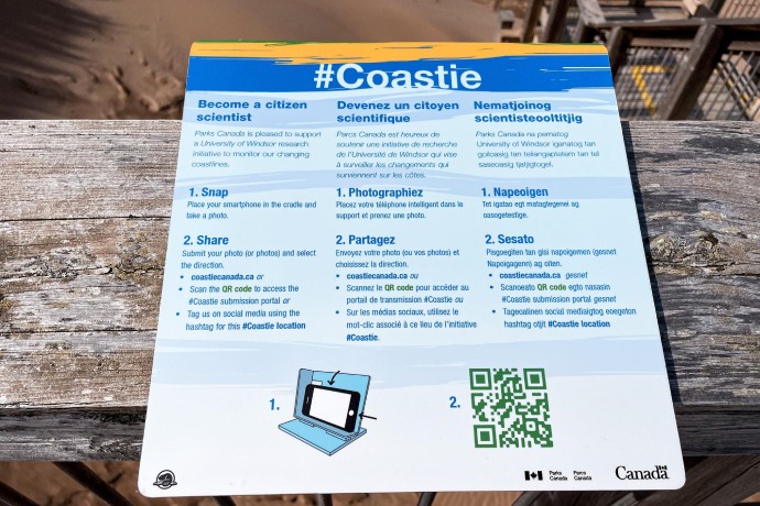
Simply place your phone as shown on the information panel near the cradle and take a photo of the coast. Your Coastie can only be used for science when you share it!
Share your Coastie
It’s easy! There are 2 ways you can share your Coastie with us:
- Scan the QR code near the cradle to submit your photos on the Coastie website.
- Share on social media and use the #Coastie hashtag (make sure your post is public).
Instructions for how to share photos are available on-site at each Coastie location.
Participating sites
There are over 30 Coastie stations in 10 Parks Canada administered sites across the country, with more being added soon. Come take a Coastie for yourself at participating sites in the following provinces:
Prince Edward Island
Prince Edward Island National Park
- Brackley Beach - East
- Brackley Beach - West
- Cavendish Beach - East
- Cavendish Beach - West
- Greenwich Floating Boardwalk - West
- Greenwich Main Beach - East
- Stanhope Beach - West
Nova Scotia
Cape Breton Highlands National Park
- Ingonish Beach - North
- Ingonish Beach - South
Kejimjujik National Park Seaside
- St. Catherines River Beach
- MacLeods Cove
Sable Island National Park Reserve
- South beach - West Light - East
- South beach - West Light - West
New Brunswick
Fundy National Park
- Alma Beach Intertidal Zone
- Alma Beach Shoreline
- Herring Cove Beach
Kouchibouguac National Park
- Callanders Beach
- Kellys Beach Boardwalk
- Ryans
Newfoundland
Gros Morne National Park
- Shallow Bay Campground Day Use Area
- Shallow Bay Campground - North East
- Shallow Bay Campground - South West
- Steve’s Trail, Western Brook
Terra Nova National Park
- Buckley’s Cove
Quebec
Forillon National Park
- Anse-aux-Amérindiens
- Cap-des-Rosiers
- Penouille
- Petit-Gaspé
Ontario
Point Pelee National Park
- Northwest Beach - North
- Northwest Beach - South
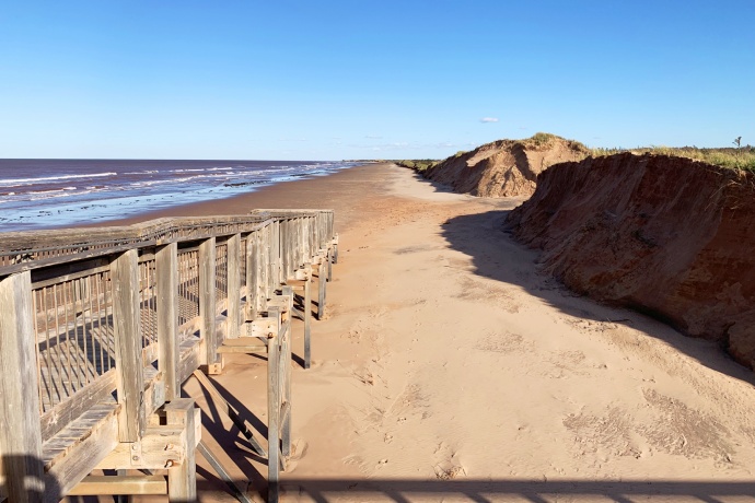
Every Coastie matters
Help Parks Canada monitor coastal changes over time.
Once you have shared your Coastie with us, researchers at the University of Windsor Coastal Research Group will transform your photo into usable data. They will add it to a database of thousands of other Coasties, which tell an almost real-time story of coastal dynamics.
Researchers, including from Parks Canada, will use your Coastie to track all kinds of coastal changes, such as:
- shoreline retreat
- dune erosion and recovery after extreme weather events
- storm surge
- the presence of nearshore ice
- vegetation structure
- beach use
- the location and size of rip currents
Since launching in September 2021, over 2,300 Coasties have been taken. They have helped to track the impact of extreme weather events, most notably the powerful impact of Hurricane Fiona in Prince Edward Island National Park.
Climate Crew: Coasties
Go behind the scenes with the researchers and watch Parks Canada’s Climate Crew at Prince Edward Island National Park using Coasties to reduce the effects of climate change, and to help us adapt.
Text transcript
It can feel like the climate is changing faster than we can react.But there are people doing good work.
There is a Climate Crew.
There. Awesome.
Thanks Terry!
Another Coastie station ready to go.
Great. Good.
Yeah, so when you take a photo of yourself, that's a selfie.
When you take a photo, of the coast, that's a Coastie.
So this is the Coastie initiative.
When you take a Coastie and submit it to Coastie,
researchers at the University of Windsor are able
to compare it against past photos taken from that same station.
And from those photos they're able to quantify the types of changes that are occurring.
That provides us with an additional opportunity to
better understand how the ecosystem is responding,
especially important in light of climate change.
The most remarkable thing that we're seeing is that
Coasties allow us to track the impacts of particular storm events.
So we can compare Coasties from before a storm occurred to
Coasties taken after that and understand what is the
particular impact of a given weather event.
There are a number of species of risk that depend on
this coastal ecosystem Piping Plover and Bank Swallows both find home here.
By understanding where their habitat might be, we can better
plan to ensure that they have the space necessary to thrive.
You see the Plover directly ahead?
Yeah. Good eye.
It seems that they've chosen really great habitat this year,
It's great that we can close these areas off for the plover.
But is there anything else we can do in a changing landscape for the species?
So when we manage for change in Prince Edward Island National Park, we use the RAD framework.
Resist, accept or direct.
So these are three broad categories of management options that we can consider.
But accept doesn't mean we're not doing anything, does it?
No.
So, in a protected area like Prince Edward Island National Park, whether by taking a Coastie or using our
binoculars to look at Plover today, these are all
monitoring strategies that we can use to understand the long
term health of the population and the habitat and accept
change so we can provide these species with the right
conditions to ensure that they'll be as resilient to climate change as possible.
How a Coastie becomes data.
A visitor takes a Coasite.
How exactly do you turn that photo into something usable?
We use the Coast Snap Australia program.
It takes a Coastie photo and it spits out an aerial overlay.
So this is actually an accurate map in space.
So that's useful data now.
It's extremely useful.
And then what the program does is it takes the rectified image
and it's looking at the differences in color between
the beach and the water, and then it delineates the actual shorelines.
So what are the Coasties telling you about how the dune systems are different across Prince Edward Island National Park?
So the Coasties are really helping us hone in on the erosion hotspots.
We are seeing a faster rate of erosion on the east end of Brackley than we're seeing on the Cavendish beach.
So we can do that with every Coastie taken.
Yes.
A visitor takes a Coasite.
So the more visitors that are contributing to the dataset is going to increase the frequency of our shoreline data point.
Wow!
So every Coastie matters?
It does. It really does.
This is a place that has been shaped by Mother Nature for thousands of years.
What's great about the Coastie Initiative is that it's an
accessible citizen science program that allows Canadians
the opportunity to feed into our understanding of climate
change impacts and use these protected areas as a living lab for climate change research.
- Date modified :