Déline Fishery / Franklin's Fort National Historic Site of Canada
Déline, Northwest Territories

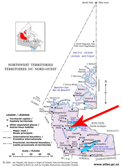
Map of the Northwest Territories
© Atlas of Canada, http://atlas.nrcan.gc.ca
Address :
Déline, Northwest Territories
Recognition Statute:
Historic Sites and Monuments Act (R.S.C., 1985, c. H-4)
Designation Date:
1997-09-22
Dates:
-
1825 to 1827
(Significant)
Event, Person, Organization:
-
Sir John Franklin
(Person)
-
Peter Warren Dease
(Person)
-
Sahtu Dene
(Organization)
Other Name(s):
-
Déline Fishery / Franklin's Fort
(Designation Name)
Research Report Number:
1996-024, 2009-SDC-CED-069, 2011-SDC-CED-005
Plaque(s)
Existing plaque: Déline, Northwest Territories
For thousands of years the Sahtu Dene have cooperatively used Déline ("where the water flows") as their major year-round food source, because the water does not freeze over. They shared this abundant fishery with Sir John Franklin's exploration party in 1825-1826, enabling it to establish winter quarters here. Dene hospitality encouraged further European expeditions but added pressure to Déline, eventually forcing some Dene to move to other fisheries. The Déline Fishery and the remains of Franklin's Fort speak eloquently of the interrelationship between the Sahtu Dene and the first Europeans.
Description of Historic Place
Déline Fishery / Franklin's Fort National Historic Site of Canada is situated on the western shore of Great Bear Lake in the Mackenzie River drainage basin 550 kilometres northwest of Yellowknife in the North West Territories. Now located within the small community of Déline, the fort was constructed on the site of a traditional seasonal Déline fishery at the headwaters of the Bear River. This was the wintering site for a group headed by Sir John Franklin, who, starting in 1825, mapped part of the Arctic coast of Canada. The fort provided a staging area and winter quarters for two years, from 1825 to 1827, during his second overland expedition. There are no known above ground remains. Official recognition refers to the site and its archaeological remains.
Heritage Value
Déline Fishery / Franklin's Fort was designated a national historic site of Canada in 1996 because: together they speak eloquently to the relationship which evolved in the 19th century between Aboriginal people in the north and those Euro-Canadian parties who were determined to explore it; Fort Franklin is associated with the most successful of Sir John Franklin’s overland expeditions; the success of the expedition, as well as of later expeditions which used Great Bear Lake as a base for exploration, could be attributed, in large part, to the richness of the fishery and to the support and assistance of the Dene and Métis people; the impact of the Franklin expedition and those which were to follow on the Aboriginal people of the region contributed to the emergence of the Sahtu Dene as a distinctive cultural group; the Sahtu Déné see the fishery at Déline as being of particular cultural significance to their occupation of the region.
Constructed to provide a wintering place for nearly 50 people in Sir John Franklin's second overland expedition from 1825 to 1827, Fort Franklin was sited to take advantage of a highly productive Aboriginal fishery. Factor Peter Warren Dease of the Hudson's Bay Company selected one of the most productive Déné fisheries in the Mackenzie River drainage area, parts of which remain ice free, as the location of the Fort. Historic prints of Fort Franklin show a cluster of small structures including a small tower. During 1820’s the Hudson Bay Company re-opened its store in order to supply Franklin's expeditions. The second expedition came into close contact with the Dogrib who wintered there, and with the Hare-Slavey and Gwich'in who journeyed from along the north shore of Sahtu to trade meat and furs. Great Bear Lake and Great Bear River became important trade routes. The Sahtu Déné supplied the post with food and guided the mapmakers during their stay from 1825 to 1827.The trade for meat and fish with the Déné of Great Bear Lake was crucial to the expedition's food supply and survival. This exchange enabled the expedition to avoid the supply difficulties faced during the first expedition. Dr. Richardson a Naval surgeon provided the local population with medical care in exchange for supplies and aid.
The discovery of pitchblende at Port Radium and oil at Norman Wells encouraged growth around the site at Fort Franklin in the 1920s, and further development occurred in the 1940s and 1950s when a period of construction centred on the Roman Catholic Mission, the Federal Day School and the post of the Hudson Bay Company. The community become a permanent settlement in 1952. In 1993, Fort Franklin officially changed its name to Déline, which is now largely inhabited by people of the Déné and Métis communities. The present-day community of Déline has had a long-standing interest in Old Fort Franklin and in the site's power to explain its own past.
Sources: Historic Sites and Monuments Board of Canada, Minutes, November 1975, November 1996, June 2004, July 2005.
Character-Defining Elements
The key elements that contribute to the heritage character of this site include: its location on the western shore of the Great Bear Lake on the north shore of Keith Arm near where the lake joins the Great Bear River on its way to the Mackenzie River; the setting of the fort, within the present settlement of Déline; the footprint and remains of the buildings that constituted the fort including evidence of the construction, materials, functional use and siting of the buildings; the evidence, mostly below ground, of life at the post, including those artefacts excavated from the site and in storage at the Prince of Wales Northern Heritage Centre; the integrity of the surviving archaeological remains, features and artefacts in their original placement and extent, including the in situ vestiges and various discrete archaeological features both identified and as yet unidentified that lie both above and below ground that relate to the site’s use during the 1820s.