Lower Fort Garry National Historic Site of Canada
Selkirk, Manitoba
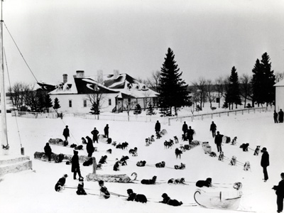
Historic view
© Parks Canada Agency / Agence Parcs Canada
Address :
Highway 9, Selkirk, Manitoba
Recognition Statute:
Historic Sites and Monuments Act (R.S.C., 1985, c. H-4)
Designation Date:
1950-05-31
Dates:
-
1830 to 1850
(Construction)
-
1830 to 1911
(Significant)
-
1870 to 1870
(Significant)
Other Name(s):
-
Lower Fort Garry
(Designation Name)
Research Report Number:
1968-029; (also 1950 pp. 26-28), 2002-SDC/CDE-027
DFRP Number:
12705 00
Plaque(s)
Existing plaque: Near entrance to Lower Fort Garry NHSC visitors centre Highway 9, Selkirk, Manitoba
One of the finest collections of early stone buildings in western Canada, Lower Fort Garry was built for Governor George Simpson of the Hudson's Bay Company between 1831 and 1848. Schooners linked Norway House to the Fort which was a focus for industry and transport in the lower Red River Settlement. Its farm helped supply food for boat brigades and oxen for Red River carts. After 1870 the Fort was used as a federal prison and the first training base for the North-West Mounted Police. It housed the Motor Country Club from 1913 to 1962 and was given to Canada by the Hudson's Bay Company in 1951.
Description of Historic Place
Lower Fort Garry National Historic Site of Canada is a former fur trade post, once the most extensive in western Canada. Situated near Winnipeg, Manitoba, 30 km. upstream from the junction of the Assiniboine and Red Rivers, this 85-acre site encompasses a four-acre Hudson’s Bay Company fort comprised of several buildings within a stone wall, a number of restored and reconstructed buildings outside the walls, as well as a portion of the camping sites of over 2,000 Ojibway and Swampy Cree people who attended the signing of Treaty 1. The designation refers to this cultural landscape in its entirety. It is now operated by Parks Canada as a historic site open for public visitation.
Heritage Value
Lower Fort Garry was declared a National Historic Site because: it is the place where Treaty Number 1 was made between the Ojibway and Swampy Cree of Manitoba and the Crown, its assemblage of fur trade structures is a significant example of early stone architecture, it played the role of major supply centre for the fur trade of Western Canada aided by its strategic location for water transport.
Lower Fort Garry was established by the Hudson’s Bay Company in 1830, and operated as a company post until 1911. Construction of the fort itself (1830-1850s) was largely guided by Governor George Simpson. After the Government of Canada acquired Hudson’s Bay lands in the west (1870), various government officials and functions occupied the fort’s facilities together with fur trade officials; as a result, the fort has been both witness and symbol for much of western Canada’s early history. From 1913-1962 the fort was leased to the Motor Country Club. The Hudson’s Bay Company donated the complex and its associated land to Parks Canada in 1951, and since then (1965-1982) many of its structures have been restored and interpreted to the 1850-1860 period for public visitation.
The heritage value of Lower Fort Garry lies in its role as witness to the negotiation and signing of Treaty 1, and to over a century of Hudson’s Bay Company administrative and supply activities. Its value is embedded in its location, its setting, orientation and composite elements. The buildings of the fort are of particular importance for their assemblage, design, materials, construction technology, functional and spatial disposition.
Source: Historic Sites and Monuments Board of Canada, Minute, February 1951; Commemorative Integrity Statement, 1999.
Character-Defining Elements
Key elements which contribute to the heritage value of this site include: the location and setting in relation to the river; the orientation of the site towards the river; the relative locations of the fort and the First Nations encampments related to Treaty Number 1; the spatial distribution of individual structures within the fort walls; the massing and profiles of individual buildings both inside (the Big House, Men’s House, Furloft and Warehouse) and outside (Donald Ross Cottage, Blacksmith Shop, Farm Manager’s House) the wall; the vernacular architectural forms with their rectangular massing under pitched roofs, simple Georgian details, and surviving original, primarily stone, construction materials; evidence of original interior layouts and materials during the fur trade era; the construction technologies and quality of original craftsmanship of particular structures (for example, columbage pierrote for the Men’s House); evidence of the form, materials and assembly of specific buildings within the group in time periods when they have specific individual relevance to the history of western Canada (i.e. the original composition of the Big House, the appearance of Ross Cottage while it was occupied by each of its six significant tenants); the footprint and profile of the wall and its bastions and evidence of original masonry work, specifically in the moderate degree of surviving original fabric on its south and west walls and northwest and southwest bastions; the integrity of archaeological resources (both above and below ground), related to fur trade era, including those that display architectural design and fabric, those associated with Treaty 1, and those that witness fur trade life; the integrity of natural and man-made landscape features related to fur trade use of the fort; surviving viewscapes from the fort towards the river and adjacent open spaces, to nearby Métis river lots, and up and down the river.