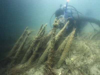
Mnjikaning Fish Weirs National Historic Site of Canada
Atherley, Ontario

Underwater view
© Agence Parcs Canada / Parks Canada Agency, 2006.
Address :
Atherley, Ontario
Recognition Statute:
Historic Sites and Monuments Act (R.S.C., 1985, c. H-4)
Designation Date:
1982-06-12
Dates:
-
1650 to 1650
(Significant)
Other Name(s):
-
Mnjikaning Fish Weirs
(Designation Name)
Research Report Number:
1982-SUA, 2000-OB-04, 2005-084, 2006-SDC/CED-006
DFRP Number:
09731 00
Description of Historic Place
Mnjikaning Fish Weirs National Historic Site of Canada is located on portions of the bottom of the Narrows between Lakes Simcoe and Couchiching, a part of the Trent-Severn Waterway. This includes the navigable marked channel, the old channel that runs to the northeast and marshland surrounding these channels. The constriction of the Narrows allows fish to be caught as they move between the lakes, and the shallowness of the channel permits wooden weirs to be built there. The channel today is divided in two: the original channel curves to the northeast, and the navigation channel runs straight to the north. The navigation channel was first dredged in 1856-57, and dredging has also taken place in the original channel south of the junction. A linear island has been created along the eastern side of the navigation channel. A causeway for an old Canadian Pacific Railway bed runs across the north end of the narrows. Marshland lies in between these channels, and also east of the old channel. A third channel seems to have existed in the past, curving to the west of the navigation channel and it has been largely filled in by modern development. The official recognition refers to the location of the weirs underwater in the channel between the two lakes.
Heritage Value
Mnjikaning Fish Weirs was designated a national historic site of Canada in 1982. It is designated because: the site contains the largest and best preserved wooden fish weirs known in eastern North America, in use from about 3300 B.C. until the recent past; the site was cared for and used by the Huron-Wendat in the centuries immediately before A.D. 1650, and today the Anishinaabeg are stewards of the site; and for these two groups, this is a sacred place that represents an ancient and ongoing spiritual bond between the Creator and all living things. The spirits of people, water, animals, birds and fish are seen as all coming together in respect and gratitude at Mnjikaning.
The oldest wooden stakes are clustered in the east channel, and samples taken from the stakes have provided carbon dates in excess of 5000 calendar years old. This falls within a time period referred to by archaeologists as the Late Archaic. Little is known about this area in this period of time, and so archaeologists cannot describe the cultural affiliations of the earliest people who used the weirs. Another cluster of 12 radiocarbon dates falls within the time that the Huron-Wendat and their immediate ancestors lived in the area around the Narrows.
Sources: Historic Sites and Monuments Board of Canada, Minutes, October 2005 and March 2006.
Character-Defining Elements
Key elements contributing to the heritage value of this site include: any surviving stakes from the Late Archaic era and from the Huron-Wendat era, their materials, and their current location and condition; the relationship between the location of the stakes, the designated place, and surviving natural elements of the waterway and shoreline evocative of the time of use and occupation; viewscapes along the shoreline towards the designated place.