Fort Erie National Historic Site of Canada
Fort Erie, Ontario
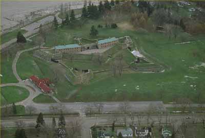
General view
© Parks Canada Agency / Agence Parcs Canada, 1991.
Address :
350 Lakeshore Road, Fort Erie, Ontario
Recognition Statute:
Historic Sites and Monuments Act (R.S.C., 1985, c. H-4)
Designation Date:
1931-05-28
Dates:
-
1805 to 1808
(Construction)
-
1764 to 1799
(Significant)
-
1783 to 1803
(Significant)
-
1814 to 1814
(Significant)
-
1937 to 1939
(Significant)
Event, Person, Organization:
-
War of 1812
(Event)
-
General Gordon Drummond
(Person)
Other Name(s):
-
Fort Erie
(Designation Name)
Research Report Number:
2007-SDC/CED-026
Plaque(s)
Original Plaque: 350 Lakeshore Road, Fort Erie, Ontario
These restored walls and ramparts, built in 1805-1808, formed part of the third Fort Erie. Dismantled in May, 1813, but rebuilt in January, 1814. On 3rd July, 1814, it surrendered to invaders who made it the strong point of an entrenched camp.
Here their army, defeated at Lundy's Lane, fled for shelter. Unsuccessfully besieged by the British in August and September, 1814: evacuated on 5th November, 1814.
Existing plaque: At main gate of Fort Erie 350 Lakeshore Road, Fort Erie, Ontario
Three fortifications occupied this site. The first (1764-1779) and second (c. 1783-1803), located at lower levels, were abandoned when ice and water inundated the works. The third Fort Erie, built between 1805 and 1808, was repaired in January 1814 but was captured by an invading American army in July of that same year. The Americans used it as a base for subsequent operations, retreated here after their defeat at Lundy's Lane, survived a siege by the British in August and September, and destroyed the fort on November 5, 1814. It was rebuilt by the Niagara Parks Commission in 1937-1939.
Description of Historic Place
Fort Erie National Historic Site of Canada is a pentagonal stone fortification strategically located on the shore of Lake Erie at the mouth of the Niagara River in Fort Erie, Ontario. Situated on a flat landscape adjacent to the river, the present structure is the fourth fort to be constructed under the name of Fort Erie on this site. The fort includes various buildings such as a guardroom, barracks and powder magazine, archaeological resources and reconstructed components. Official recognition refers to the parcel of land that is 8 hectares (17½ acres) surrounding the location of Fort Erie.
Heritage Value
Fort Erie was designated a National Historic Site of Canada in 1931 because: during the War of 1812, it was captured by an invading American army in July 1814, who used it as a base of operations and then retreated here after their defeat at Lundy’s Lane; and, it survived a siege by the British in August and September, and was destroyed by the retreating Americans in November 1814.
The heritage value of Fort Erie lies in its historical associations and in the archaeological remains of previous fortifications. Four different forts under the name of Fort Erie have been constructed on this site. The first (1764 –1799) and the second (c. 1783-1803) were abandoned when the fortifications were destroyed by high water and ice in the spring of 1779. The third Fort Erie, built by the British between 1805 and1808, was rebuilt in January 1814, but was captured by an invading American army in July of the same year. The Americans used the fort as a base of operations and then retreated there after their defeat at Lundy’s Lane. After surviving a siege by the British under General Gordon Drummond the Americans abandoned the fort and destroyed it on November 5, 1814. The fort remained in this ruined state although the lands around it were surveyed and settled by military pensioners and by other settlers. In 1901 the property was granted to the Niagara Parks Commission who restored the fort to its 1814 state between 1937 and 1939. Fort Erie continues to be operated by the Niagara Parks Commission.
Sources: Historic Sites and Monuments Board of Canada, Minutes, May 1933; December 2007; Historic Sites and Monuments Board of Canada, Plaque Text, 1933.
Character-Defining Elements
The key elements that contribute to the heritage character of this site include: its location on the Niagara peninsula in the town of Fort Erie; its setting on a flat grassed parcel of land overlooking Lake Erie at the mouth of the Niagara River; the remains of the 0.91 metres (3 foot) thick fieldstone curtain walls and the foundations of the fort (surviving from the 1812-1814 period) that form part of the current exterior walls; the integrity and materials of the archaeological remains, features and artefacts in their original placement and extent, including the in situ vestiges, and various discrete archaeological features both identified and as yet unidentified that lie above and below ground, surviving from the pre-1814 period; the visual and landscape character within and surrounding the fort, including unimpeded viewscapes from the fort across the Niagara River to Buffalo, New York.