
Drawings, maps and other media
Parks Canada Archaeological Recording Manual: Excavations and Surveys
8.0 DRAWINGS, MAPS, and OTHER MEDIA
The following procedures allow field records such as drawings and maps, as well as “media” such as magnetometer and sonar data generated during a field project, to be documented in a standard manner. The procedures also ensure that core data is associated with the original record, and facilitate the efficient transfer of data to an archaeological database or a paper-based record system. Central to the effective management of field drawings, maps, and other media are the Drawing and Media Catalogue Number systems, in tandem with the recording of key metadata for each type of record.
For the purpose of this Manual, “media” refers to the means by which something is communicated, such as instrument-derived data, audio, video (“moving images”), and forms, in either paper or digital format. “Moving images” refers to images created by video cameras, film cameras, etc. in either digital or analog tape format. The cataloguing procedure for media is a new introduction with this Manual, and is an adaptation of the drawing cataloguing procedure employed in previous years.
8.1 PRINCIPLES
- Records are prepared in such a manner that Collections Management staff from the appropriate Parks Canada Service Centre can assure their efficient and complete entry into the records/database system.
- Copies, or digital data backups (as applicable) are made for all original drawings, maps, and other media according to the Collections Management standards of the appropriate Parks Canada Service Centre.
- Core metadata pertaining to each record is recorded, and to ensure the long-term preservation or integrity of the record and associated data. Every effort should be made to keep current with latest Parks Canada initiatives on Digital Multimedia Asset Management and Metadata Standards.
- Metadata for digital files are included with each digital file. If not resident in the file itself, the essential metadata are recorded in the field notes.
8.2 DATA STANDARDS for DRAWINGS, MAPS and OTHER MEDIA
Field drawings, plans, and maps must, at a minimum, provide the information under the following headings:
- Drawing Catalogue Number (see Section 8.2.2);
- Provenience;
- Description;
- Scale (e.g., 1:15; 1:50,000);
- Date (in format: yyyy-mm-dd);
- Staff Field Number (or full name of archaeologist);
- References (Field Notebook page reference); and
- include a north arrow (if applicable; depicting true, magnetic, or grid north).
As a best practice, the following should be included, if the data is applicable or available:
- coordinates;
- elevation.
These elements are described below. As a best practice, all drawings should be done in the metric system.
An example of a drawing record format (or card) for entering drawing data is shown in Figure 7. This is a variation of the Drawing Stamp and Card system used in previous versions of the Manual (see Parks Canada 1978:57). The format may also be adapted for maps (e.g., NTS topographic maps).
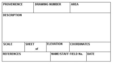
Figure 7. Example of a drawing record format (or card) for entering drawing data. Redrawn by S. Savauge, from Parks Canada (1978).
8.2.1 Provenience
Enter the most inclusive Provenience Number. Depending on the content of the record, this may be a Site, Operation, Suboperation, or Lot Number. The complete Provenience Number must be used, e.g., 2E43 or 2E43Q or 2E43Q48 would be correct, but 43Q48 or Q48 or other variations of partial provenience numbers are not acceptable.
8.2.2 Drawing Catalogue Number
The Drawing Catalogue Number or “Drawing Number” should be used to catalogue all key drawings, plans, and maps used or generated during the course of a field project. The Drawing Catalogue Number comprises the Site Number, Date (yyyy-mm-dd), Staff Field Number, and Drawing Number, separated by hyphens, as shown in the examples below and Table 8.
The Drawing Number denotes the drawings made by an individual, not the total of drawings for a project. The Drawing Numbers begin sequentially from number “1”. For computer input, the drawing number groups are justified to the right, e.g., 009K-2004-7P-D005.
Examples
5H-2004-101H-D1
18H-2004-101H-D2
134H-2004-101H-D3
134H-2004-101H-D4
From the hypothetical examples above, one can determine at a glance that Staff Field Number 101H (“John Smith”) generated four separate field drawings at three different sites (5H, 18H, and 134H) in the year 2004.
Table 8. Drawing Catalogue Number Components.
| Site Number | Year (yyyy) | Staff Field Number | Drawing Number |
|---|---|---|---|
| 5H | 2004 | 101H | D1 |
8.2.3 Area
Identify the structure, part of a structure or activity area of which the record was made, e.g., “Latrine.”
8.2.4 Description
Identify the drawing as a plan, section (profile), or elevation, and provide a statement of the drawing content and purpose (if applicable).
Examples
“Plan of casemate floor showing location of in situ archaeological objects”
“Plan of tent ring showing hearth, sleeping platform and cold trap”
“Elevation of north face (exterior) of doorway”
“Map of Operation 2E19 showing locations of Suboperations and limits of excavation”
“Elevation showing soil profiles of north-east face of suboperation 15H21D”
To specify content, additional Provenience Numbers should be added where applicable. For
example, a plan of Suboperations 2E13Q and 2E13R would have the Operation Number 2E13
entered in the “Provenience” field (Section 8.2.1) and the specific Suboperation Letters listed in this
“Description” field.
8.2.5 Scale
Enter the scale to which the drawing was made.
Example
“1cm = 1m” or A1:100"
8.2.6 Date
Enter the date on which the drawing was made, in numerical format: yyyy-mm-dd.
Example
The first day of July, 2005 would be entered as 2005-07-01.
8.2.7 References
Enter the Drawing Catalogue Numbers of the related drawings, including those of other sheets in the case of a composite drawing or mosaic. Also enter related field note pages or forms.
8.2.8 Coordinates and Elevations
Where possible, enter the spatial or geographic coordinate data pertinent to the drawing (See the Parks Canada Archaeological Site Inventory Form Guide, Appendix A, for examples and descriptions).
8.3 MAPS
A vast array of Topographic (e.g., NTS maps) and other maps (e.g., forestry maps, hydrographic charts, orthographic maps, Geographic Information System (GIS) maps) of various scales are often used to plot the locations of archaeological sites, or indicate vegetation, landforms, and other information for predictive modelling, etc. These maps or representations may be in either paper or digital format, or sometimes both, and may be acquired externally (e.g., from Geomatics Canada) or generated internally (e.g., from a Service Centre GIS database).
When original field data is recorded on such maps, and where the information does not appear elsewhere (e.g., on a master map), the map should be assigned a Drawing Catalogue Number as described above, which should be cross-referenced to the field notes.
On return from the field, the map will be catalogued into the Collections Management System according to jurisdictional Service Centre Collections Management procedures.
8.4 OTHER MEDIA
This section outlines best practices for cataloguing such media records as remote sensing data, digital and analog video and audio files and tapes, as well as geographic and navigational data, and forms.
The Media Catalogue Number is the cataloguing method for media in either digital or analog format, which is a variation of the Drawing Catalogue Number described above. As is the case for the Drawing Catalogue Number, the Media Catalogue Number comes with a requirement to record associated metadata for each record.
8.4.1 Media Catalogue Number
The Media Catalogue Number comprises the Site Number, Year, Staff Field Number, and Media Number, separated by hyphens. The Media Catalogue Numbers begin sequentially from number “1”, and denote the records made by an individual, not the total of drawings for a project.
Example
9K-2004-137P-R1 is the first Remote Sensing Data record (R1) generated in 2004 at York Factory NHSC (9K), Manitoba by Staff Field Number 137P (Jim Doe)
Additional Examples
5H-2004-101H-A1;
5H-2004-101H-R1;
18H-2004-101H-R2;
134H-2004-101H-G1;
134H-2004-101H-G2
From the hypothetical examples immediately above, one can determine at a glance that Staff Field Number 101 H (“John Smith”) generated five separate media records (one audio record, two remote sensing records, and two geographic data records) at three different sites (5H, 18H, and 134H) in the year 2004.
8.4.2 Codes for Media Records
As a best practice, the following codes (Table 9) are applied to media records, which include digital files and outputs (e.g., magnetometer output/printout), and analog tapes (e.g., video, audio tapes).
Table 9. Valid Codes for Media Records, with Descriptions and Examples.
| Code | Description | Examples |
|---|---|---|
| A | Audio | Digital audio files, analog tape formats (with no video component) |
| F | Forms | Suboperation Summary Form, Lot Summary Form |
| G | Geographic Data | Global Positioning System Data, Geographic Information System Data, Boat Navigation Data |
| R | Remote Sensing Data | Gradiometer Data, Magnetometer Data, Ground Penetrating Radar Data, Electrical Resistivity/Electromagnetic Conductivity Data, Sonar Data (such as Side Scan; Sector Beam; Multi-Beam; Sub Bottom Profiler), Satellite Remote Sensing, Aerial Photography Data (such as thermal imagery, Infrared) |
| S | Instrument Survey Data | Total Station, Transit, Theodolite, Level Data |
| V | Video | Digital video files, analog tape formats (may include associated audio components) |
8.5 MEDIA SELECTION PROCESS
As specified in the case of digital images (described above), not all records need to be catalogued; the selection for cataloguing will be based on information content, anticipated research, management requirements, as well as publication and presentation requirements. Only those files identified by the Principal Investigator or delegate to be curated into the records system and referenced in the field notes should be assigned a Media Catalogue Number.
8.6 MEDIA CATALOGUE FORM: EXPLAINED
An example of Media Catalogue Form, as well as a Form Guide, is provided in Appendix C. Though the use of the Media Catalogue Form is optional, the data fields shown in the form and explained in the Form Guide are mandatory and represent minimum data standards for Parks Canada media records. As a result, the use of the Media Catalogue Form is recommended as a best practice. The Media Catalogue Form organizes data for each type of media as it is recorded, correlates this record with the permanent Media Catalogue Number and prepares each of these records for data entry or transfer into an Archaeological Database. Relational databases can merge, cross-reference and output media data in a variety of ways to suit the needs of a given project or Service Centre’s archaeological records management system.
< Previous Page | Table of Contents | Next Page >
- Date modified :