Tonge's Island National Historic Site of Canada
Aulac, New Brunswick
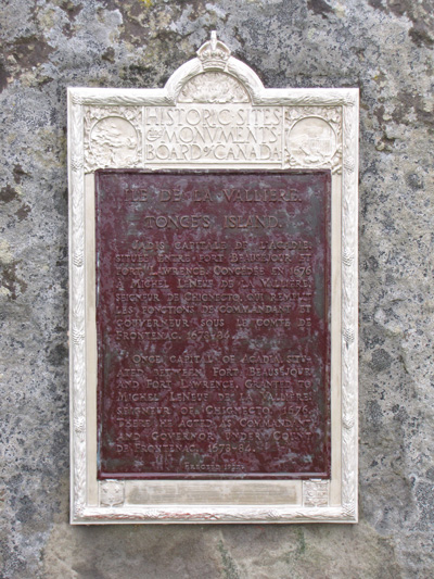
Detailed view of the HSMBC plaque
© Parks Canada / Parcs Canada, 2010 (Jim Molnar)
Address :
Highway 2, Fort Beauséjour – Fort Cumberland National Historic Site of Canada, Aulac, New Brunswick
Recognition Statute:
Historic Sites and Monuments Act (R.S.C., 1985, c. H-4)
Designation Date:
1925-05-15
Dates:
-
1676 to 1676
(Construction)
-
1678 to 1684
(Significant)
Event, Person, Organization:
-
Acadians
(Person)
-
Michel le Neuf de la Vallière
(Builder)
Other Name(s):
-
Tonge's Island
(Designation Name)
Research Report Number:
2007-CED/SDC-016
Plaque(s)
Existing plaque: in Fort Beauséjour / Fort Cumberland National Historic Site Highway 2, New Brunswick
Once capital of Acadia, situated between Fort Beauséjour and Fort Lawrence. Granted to Michel LeNeuf de la Vallière, Seigneur of Chignecto, 1676. There he acted as Commandant and Governor under Count Frontenac, 1678-84.
Description of Historic Place
Tonge’s Island National Historic Site of Canada is located on a triangular section of land known as the Tantramar Marsh, near Sackville, New Brunswick. An important Acadian settlement, the site consists of a low hill covered with brackish marshland, known as Tonge’s Island, located on the western side of the Missiguash River. Official recognition refers to the hill known as Tonge’s Island.
Heritage Value
Tonge’s Island was designated a national historic site of Canada in 1925 because: it was the capital of Acadia, 1678 - 1684.
In 1676, Michel le Neuf de la Vallière was granted a small section of land on the southwest coast of the Isthmus of Chignecto, across the Missiguash River from the small Acadian settlement of Beaubassin. La Vallière set up his manor west of the river, on a low hill surrounded by brackish marshland. His small settlement expanded, with the Acadians applying their aboiteaux to slowly drain and desalinate the marshes, and eventually a stockade and a mill were constructed.
When la Vallière became the governor of Acadia in 1678, his settlement on Tonge’s Island became the capital. The settlement served as the capital of Acadia until 1684 when, because of a dispute with other seigneurs over the granting of fishing licenses to Bostonian ships, the French stripped la Vallière of his governorship. The settlement at Tonge’s Island languished for the next century while the community of Beaubassin across the river grew into an important Acadian town. When tensions rose between the British and French, the Beaubassin villagers fled west across the Missiguash River to the newly built Fort Beauséjour on the ridge north of the marsh, and their new settlement became focused there, rather than on the less-defensible Tonge’s Island.
Sources: Historic Sites and Monuments Board of Canada, Minutes, May 1926, May 1927, July 2007.
Character-Defining Elements
Key elements contributing to the heritage value of this site include: its siting on the Chignecto isthmus, a region that was hotly contested during much of Canadian history by French, English and Acadian forces; the geographic location of the “island” within the surrounding landscape on a slight rise of land that defines the approximate boundary of Tonge’s Island and the settlement of Michel le Neuf de la Vallière; its proximity to other Acadian sites, including Beaubassin, Fort Beauséjour and Fort Lawrence National Historic Sites of Canada; the surrounding viewscapes and terrain including to the Missiguash River and farmland to the east, the dyked marshland to the northwest, and Chignecto Bay to the south; the integrity of any surviving or as yet unidentified archaeological remains which may be found within the site in their original placement end extent.