Arvida National Historic Site of Canada
Saguenay, Quebec

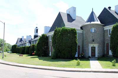
The Britanny Row apartment building
© Parks Canada | Parcs Canada
Address :
Arvida, Jonquière, Saguenay, Quebec
Recognition Statute:
Historic Sites and Monuments Act (R.S.C., 1985, c. H-4)
Designation Date:
2012-06-05
Dates:
-
1926 to 1935
(Construction)
-
1926 to 1926
(Significant)
-
1926 to 1927
(Significant)
-
1942 to 1942
(Significant)
-
1942 to 1950
(Significant)
-
1945 to 1945
(Significant)
-
1939 to 1940
(Additional alteration)
-
1936 to 1940
(Addition)
-
1927 to 1927
(Other addition)
-
1925 to 1925
(Acquired)
Other Name(s):
-
Arvida
(Designation Name)
Research Report Number:
2011-042
Plaque(s)
Founded in 1926 as a community for employees of Canada’s first complex for aluminum production, Arvida is an outstanding example of a planned, single-industry town. Its name was derived from the first two letters of the three names of Arthur Vining Davis, president of the Aluminum Company of America. Architect H. B. Brainerd and engineer H. E. Skougor were commissioned to prepare plans for a city that would reflect the company’s standards of excellence. The urban plan constitutes an original synthesis of a variety of town planning theories and contemporary principles of urbanism, which earned Arvida an enviable reputation as a model city. The organic layout incorporates an ordered network of tree-lined streets enhanced by green spaces. Surrounding Oersted Park is the town’s original nucleus, known as “The City Built in 135 Days,” which speaks to the first of three construction phases extending from 1926 to 1950. The diversity of housing styles, some of which are successful examples of regionally inspired architecture, adds to the richness of the built environment. This well-preserved community illustrates the growth and importance of Canada’s aluminum industry during the 20th century.
Description of Historic Place
Arvida National Historic Site of Canada is located in the Saguenay-Lac-Saint-Jean region, 250 kilometers north of Quebec City. This company town, built to house employees of the local Alcoa aluminum plant, was designed as a whole, built in three phases and retains many original features. Arvida stretches northwest from the Rio Tinto Alcan plant along the shore of the Saguenay River. Crisscrossed by ravines, the residential town has an institutional zone at its heart and is encircled by a green belt. The town features family dwellings, a hotel, churches, schools, a manoir, green spaces, parks. Official recognition refers to the company town of Arvida that was designed and built in three phases from 1925-1950.
Heritage Value
Arvida was designated a National Historic Site of Canada in 2012. It is recognized because:
Arvida is a well preserved example of a Canadian company town and is a singular instance of planned quality worker housing, where a diversified urban landscape was rapidly established through a wide variety of housing styles, some of which constitute a particularly successful manifestation of regionally inspired architecture;
laid out starting in 1925 according to the plans of architects Brainerd and Skougor, the town of Arvida was completed in three successive phases running until 1950, and constitutes an excellent synthesis of the town planning concepts of the time, such as the City Beautiful and garden city movements, that are expressed by an organic layout following the lie of the land, a hierarchy of thoroughfares, and a network of parks, green spaces, and plentiful trees;
associated with Canada’s first aluminum complex, Arvida’s founding and later expansion is a testament to the growth and development of the country’s aluminum industry.
Arvida’s original plan remains clearly legible. The City Beautiful Movement is expressed in Arvida’s wide boulevards lined with trees and gently curving streets with set-back buildings. The Garden City Movement is expressed in the functional separation of zones, the presence of a greenbelt and hierarchical street patterns and the use of natural features. Both movements sought to counter the harsh environmental impact of industrial development. During the first phase of construction an impressive 270 residences were built in 135 days. In 1927 a landscape architect oversaw a campaign that resulted in the planting of 709 trees. The second and third phases of development at Arvida saw the emergence of a distinctive regionalist architecture. Many residences reflect the stylistic influence of French-Colonial vernacular in their large dormers windows and high gable roofs with curving eaves, wooden shutters, turrets, the use of rustic stone and distinctive chimney design.
Source: Historic Sites and Monuments Board of Canada, Minutes, December 2011.
Character-Defining Elements
Key elements contributing to the heritage value of this site include: its location in the Saguenay–Lac-Saint-Jean region, 250 kilometers north of Québec City; its proximity to the Îsle Maligne power plant, to Canada’s first aluminum smelter and to the Canadian National Railroad and station; clear evidence of City Beautiful town planning principles including streets that radiate from the centre, boulevards, regular setbacks for houses, ordered spaces directed towards central nodes, and extensive plantings; clear evidence of the Garden City town planning principles, including the separation of residential, service and commercial areas, a focus on social and community life, and the presence of a greenbelt; well-constructed and well-preserved housing stock dating from all three major development periods, featuring variations on single-family home plans and apartments; continued residential use that reflects the original vision for the town; significant and diverse forest canopy that includes American elms, hybrid poplars, Bay willows and silver maples; uninterrupted extensive lawns; well-built wood-framed houses with a variety of facing materials including clapboard, wood shingles, asbestos shingles, and brick; use of stone on buildings from the second and third phases of construction such as the Saguenay Inn and the Brittany Row apartment; residential aluminum roof tiles; the strategic integration of natural forms and rock formations in the landscape into the urban plan.