Beaubears Island Shipbuilding National Historic Site of Canada
Miramichi, New Brunswick

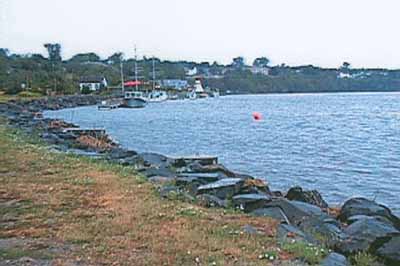
General view
(© Parks Canada Agency / Agence Parc Canada, 2001.)
Address :
Highway 8, Northwest Bridge, Miramichi, New Brunswick
Recognition Statute:
Historic Sites and Monuments Act (R.S.C., 1985, c. H-4)
Designation Date:
2002-02-21
Dates:
-
1790 to 1790
(Construction)
-
1866 to 1890
(Significant)
-
1790 to 1838
(Significant)
Event, Person, Organization:
-
James Fraser
(Person)
-
James Thorn
(Architect)
Other Name(s):
-
Beaubears Island Shipbuilding
(Designation Name)
Research Report Number:
2001-40, 2004-SDC/CDE-013
DFRP Number:
04565 00
Plaque(s)
Existing plaque: Highway 8, Northwest Bridge, Beaubears Island, Wilsons Point, New Brunswick
The extensive remains of the 19th-century shipbuilding community found on Beaubears Island form the only known undisturbed archaeological site associated with this key industry in New Brunswick. The island's large shipyard was one of a number of establishments concentrated along both shores of the Miramichi River from Wilsons Point to Burnt Church. This area, with its deep river channel and seemingly inexhaustible timber supply, was well suited to the construction of wooden ships. In operation for over 75 years, Beaubears Island was a vital component of the shipbuilding industry in the Maritimes.
Description of Historic Place
Beaubears Island Shipbuilding National Historic Site of Canada incorporates some 24 hectares (60 acres) on the southeastern (downstream) shore of Beaubears Island at the confluence of the Southwest and Northwest Miramichi River, and the adjacent south channel of the Miramichi River. The site includes the remains of an early 19th-century shipyard.
Heritage Value
Beaubears Island Shipbuilding was designated a national historic site as an example of a shipbuilding site in the Province of New Brunswick that contained in situ archaeological resources.
The heritage value of Beaubears Island Shipbuilding lies in the setting and landscape which contains archaeological resources defining the former shipyard facilities. These are typical of a New Brunswick shipyard of the early and mid 19th century in an area representing the major concentration of such sites along the Miramichi, the second largest shipbuilding centre in New Brunswick.
Source: HSMBC Minutes, November 2001.
Character-Defining Elements
Key features contributing to the heritage value of this site include: the combination of natural and archaeological features associated with 19th-century shipbuilding in eastern Canada, the archaeological evidence of shipbuilding activities on the approximately 10 hectares (25 acres) of this site, the location of the Beaubears site near the mid-stream boundary of the south river channel (into which ships were launched and where repair and refitting work was carried out as typical of the Miramichi sites), the location on the south shore of Beaubears Island, near dense woods on the balance of the island (providing ready access to the materials required for shipbuilding), the morphology of the Island, 4.5-9 metres (15-30 feet) above the sea-level, sloping towards the river (providing terrain suitable for launching and repairing the small and medium sized vessels), the integrity, relative lack of disturbance and visible fabric of both cultural landscape forms and archaeological vestiges of the facilities and distribution of Russell's Beaubears facilities including a two-storey stone house, a well, a wood house, a coach house, outhouses and a kitchen garden), near the house site (a barn, retail and provisioning store, wharf and warehouse nearby; a salt store, a lumber yard, and a timber boom attached to the eastern tip of the island), at the shipyard on the mid point of the southern shore (five slipways, a blacksmith's shop, a joiner's shop, a moulding loft, a storage shed, sawpits, a steam box and boiler), and the support facilities adjacent to the shipyard (a foreman's house, seven workers' houses, a cookhouse, a kitchen and bedrooms and accommodation for 50 workers), the integrity and relative lack of recent disturbance of the surface of the cultural landscape as identified by vegetation patterns, changes and surface disturbances that indicate the boundaries of former human activity, the distinctive sense of place created by the undisturbed past resources in the cultural landscape, the undisturbed vegetation and similar qualities of the island, and its adjacent river channel.