Bulletins
Jasper National Park
Area Closure: Seasonal closures for caribou conservation
Issued: October 30, 2024
Ends: May 16, 2025
Seasonal closures in the Tonquin, Brazeau, and À la Pêche caribou ranges of Jasper National Park take effect on November 1. Access to these backcountry areas is prohibited until they reopen for recreation on May 16.
Map areas
| Name | Description | Category |
|---|---|---|
| Tonquin Valley | Closed area |
| Name | Description | Category |
|---|---|---|
| South Boundary / Brazeau | Closed area | |
| South Boundary / Brazeau West | Closed area |
| Name | Description | Category |
|---|---|---|
| North Boundary | Closed area |
Tonquin caribou winter habitat.
Effective date: November 1, 2024 through May 15, 2025. Dates inclusive.
Access prohibited: Pursuant to section 7(1) of the National Parks General Regulations, the following area is hereby temporarily closed to all public use and travel by order of the Superintendent, Jasper National Park.
See map: www.parkscanada.gc.ca/caribou-winter-access
Where: Critical habitat in the Tonquin caribou range. Access is prohibited to the area between the following boundaries (all point coordinates fall within UTM zone 11 North):
- Boundary begins at UTM 402190 5859469 where 1325 m elevation contour line meets west park boundary just south of Highway 16;
- Follows 1325 m contour line east until UTM 413934 5857628 near Meadow Creek, then heads due east to UTM 415175 5857628;
- Follows 1325 m contour line east past Jasper Skytram then south past Whistlers Creek to an unnamed creek at UTM 427804 5851620. Note: Skytram upper terminal and 50 metres on each side of the hiking trail (5a) from the upper terminal to Whistlers Peak are excluded from the closure;
- Follows unnamed creek west upstream (excluding Edge of the World waterfall) to 426809 5851123, then straight northeast along the Marmot Basin lease boundary to UTM 426628 5851231;
- Follows 1800 metre elevation contour west to Whistlers Creek at UTM 425221 5851665;
- Follows Whistlers Creek west to UTM 424521 5851511 then a straight line to UTM 424412 5851291 on Marmot Basin leasehold;
- Follows perimeter of Marmot Basin leasehold to UTM 426912 5848956, then follows a straight line to Portal Creek Trailhead parking lot, then follows straight line from Portal Creek Trailhead to junction of Highway 93A and Cavell Road; Marmot Road is excluded from the closure;
- Continues from junction of Cavell Road and Highway 93A along a straight line to UTM 433236 5845022, then follows straight line to UTM 435100 5842518, then follows a straight line due south to 435100 5840856;
- Follows 1350 m contour line southwest and upstream along Whirlpool River to UTM 427297 5827276, then due west to UTM 426484 5827276, then west along 1600 m contour line to UTM 414528 5828103; then due north to summit of Outpost Peak (UTM 414528 5833597), then straight to summit of Bennington Peak on park boundary (UTM 412193 5834727);
- Follows Jasper National Park boundary northwards back to UTM 402190 5859469.
Why: To prevent human roads and trails from facilitating an unnatural level of predator access to woodland caribou, which are listed as Threatened on Schedule 1 of the Species at Risk Act.
Penalty: Violators may be charged under the Canada National Parks Act: maximum penalty $25 000.

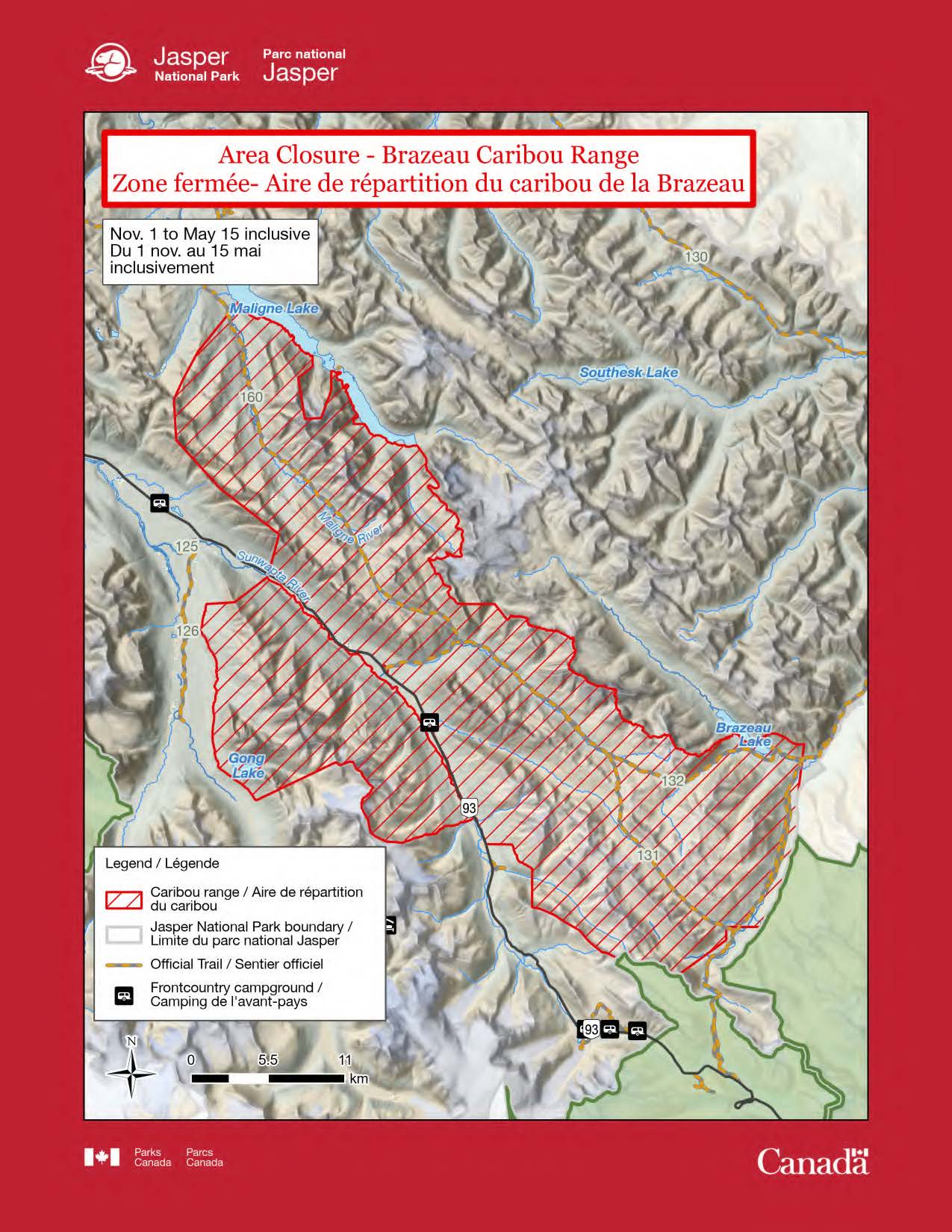
Brazeau caribou winter habitat.
Effective date: November 1, 2024 through May 15, 2025. Dates inclusive.
Access prohibited: Pursuant to section 7(1) of the National Parks General Regulations, the following area is hereby temporarily closed to all public use and travel by order of the Superintendent, Jasper National Park.
See map: www.parkscanada.ca/caribou-winter-access
Where: Critical habitat in the Brazeau caribou range. Access is prohibited to the area between the following boundaries (all point coordinates fall within UTM zone 11 North):
East side of Highway 93:
- Beginning at UTM point 459404 5837426 on the south border of Maligne River where Maligne River enters Maligne Lake, follows south along the west side of Maligne Lake to the narrows at UTM 464781 5833663;
- Follows a straight line due south to UTM 464781 5832899, then a straight line to the ridge top at UTM 463753 5832055, then from this ridge along height of land to the summit of Mount Unwin, to the summit of Mount Charlton, to ridgeline at UTM 466109 5831162, and then along a straight line due north, back to the lake edge at UTM 466109 5832571;
- Follows south along the west side of Maligne Lake past Coronet Creek to UTM 472248 5827255. Note: Spindly Creek picnic area and Coronet Creek Campground are excluded from closure boundary;
- Follows a straight line southeast to UTM 472910 5826368, then south along 2550 m contour line to UTM 475322 5815908, then due east to UTM 477803 5815908, then a straight line southeast to the peak at UTM 478724 5814797;
- Follows height of land across the Grand Brazeau Range through Poboktan Mountain to the shoulder north of John-John Creek, then down the shoulder to the west shore of Brazeau Lake, follows west shore of Brazeau Lake to John-John Creek, then along 1 km buffer north of Brazeau Loop Trail to the slopes north of Brazeau River Campground, from there straight to park boundary at UTM 499485 5802397;
- Follows park boundary south to Cline Creek and from that junction straight west to UTM 494331 5792845 above Four Point Campground and cabin, then due south to UTM 494331 5791913, then straight to height of land at park boundary northwest of Nigel Pass at UTM 491002 5789498;
- Follows park boundary northwest to height of land at UTM 486502 5790620 and along height of land to the highest point on Tangle Ridge, then due north to UTM 480469 5797011, then along 2100 m contour line to UTM 478989 5798758, then due west to the east edge of Highway 93 right-of-way at UTM 477169 5798758;
- Follows north a long the east edge of Highway 93 right-of-way to Poboktan Creek. Note: Jonas Creek Campground, Poboktan Creek trailhead parking area, and Sunwapta Warden Station are excluded from closure area;
- Follows north along the east edge of Highway 93 right-of-way to UTM 461620 5818041, then a straight line to height of land in the Endless Chain Range (known as Shackle Peak) at UTM 462396 5820863;
- Follows a straight line northwest to the peak at UTM 458200 5824146, then a straight line to UTM 455038 5827610 (known as Clevis Peak), then a straight line northeast to UTM 454875 5830530 and following northeast along height of land south of Trapper Creek to UTM 456605 5833970, then a straight line to the starting point at the mouth of the Maligne River where it empties into Maligne Lake at UTM 459378 5837389.
West side of Highway 93:
- Beginning on the west bank of Sunwapta River at UTM 461557 5817843, across from Bubbling Springs picnic area, boundary follows the west bank of Sunwapta River south for 25.4 km to UTM 476299 5800645, close to Mushroom Peak viewpoint;
- Follows height of land north of Diadem Creek and Diadem Basin to Gong Glacier, following the eastern edge of Gong Glacier to Gong Peak, continues following height of land between Gong Peak and Mount McGuire Peak and Mount Weiss Peak, follows along ridgeline northwest to UTM 466433 5804606;
- Follows a straight line west-south-west to UTM 460745 5801886 on 1600 m elevation contour line, follows 1600 m elevation contour line north to UTM 457202 5815911;
- Follows a straight line east to the Winston Churchill Range at UTM 459224 5816042;
- Follows a straight line back to boundary starting point on the west bank of Sunwapta River across from Bubbling Springs picnic area.
Why: To prevent human roads and trails from facilitating an unnatural level of predator access to woodland caribou, which are listed as Threatened on Schedule 1 of the Species at Risk Act.
Penalty: Violators may be charged under the Canada National Parks Act: maximum penalty $25 000.

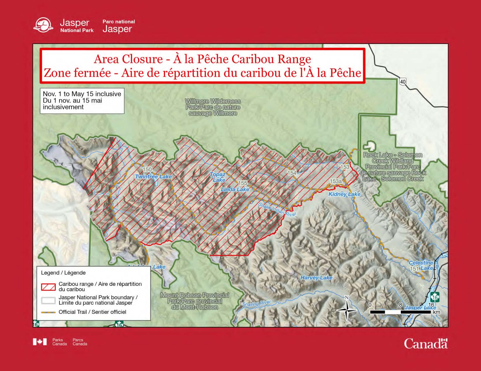
À la Pêche caribou winter habitat.
Effective date: November 1, 2024 through May 15, 2025. Dates inclusive.
Access prohibited: Pursuant to section 7(1) of the National Parks General Regulations, the following area is hereby temporarily closed to all public use and travel by order of the Superintendent, Jasper National Park.
See map: www.parkscanada.gc.ca/caribou-winter-access
Where: Critical habitat in the À la Pêche caribou range. Access is prohibited to the area between the following boundaries (all point coordinates fall within UTM zone 11 North):
- From Rock Creek's crossing of park boundary, upstream to the junction with an unnamed creek at UTM 411626 5920616, south a long this creek to creek junction at UTM 413828 5917500, and southwest along second creek to height of land at UTM 413189 5916518;
- From height of land to the junction of Willow Creek and Snake lndian River; follows Snake lndian River upstream to the junction with an unnamed creek at UTM 395150 5908263, follows main creek channel upstream to outlet of lake at UTM 384956 5896428, and from that point due west to park boundary at UTM 374826 5896428
- Follows park boundary northwest to UTM 365386 5899860 then straight to Calumet Creek at UTM 365007 5900087, follows Calumet Creek downstream to the junction with Smoky River, follows Smoky River downstream to trail junction at UTM 351995 5904790, and from that point to the peak of Palu Mountain;
- From Palu Mountain straight to Carcajou Pass on park boundary at UTM 347728 5900125, follows park boundary north to height of land on Mount Bess, and from Mount Bess straight across to park boundary at its junction with Smoky River at UTM 350583 5927592;
- Follows northern park boundary to Rock Creek.
Why: To prevent human roads and trails from facilitating an unnatural level of predator access to woodland caribou, which are listed as Threatened on Schedule 1 of the Species at Risk Act.
Penalty:Violators may be charged under the Canada National Parks Act: maximum penalty $25 000.

- Date modified :