
Fire protection and restoration projects
Public safety is at the core of everything that we do, and wildfire response is part of our daily operations. We understand the risk of wildfire in a forested community. We take actions to reduce the potential impacts of a wildfire while improving forest health. Below you will find information on fire protection and restoration projects within Kootenay National Park.
Prescribed fires
Prescribed fire operations will only be conducted when predetermined weather and site conditions are met.
Prescribed fires help to restore healthy forests and grasslands and enhance habitat for wildlife. They also help reduce the risk of wildfire to neighbouring communities.
2024 Prescribed Fires in Kootenay National Park
Kootenay Crossing Meadow
Date: Spring/Fall
Size: 38 hectares
Location: Near Kootenay Crossing warden station, in central Kootenay National Park.
Additional details:The Kootenay Crossing Meadow prescribed fire is part of a larger meadows restoration plan. This prescribed fire will restore open meadow and grassland. It will do this by encouraging re-growth of native grass and shrub species.
McLeod Meadows
Date: Spring/Fall
Size: 1.8 hectares
Location: Adjacent to McLeod Meadows Campground, in the southern end of Kootenay National Park.
Additional details: The McLeod Meadows prescribed fire is part of a larger meadows restoration plan. This prescribed fire will restore open meadow and grassland. It will do this by encouraging re-growth of native grass and shrub species.
Redstreak Ecosystem Restoration Project
Date: Spring/Fall
Size: 437 hectares
Location: Near the Village of Radium Hot Springs, along the southern boundary of Kootenay National Park.
Additional details: The Redstreak Ecosystem Restoration Project area is made up of two units – the bench unit and the mountain unit. Within these units are several sub-units. Prescribed fire operations may focus on specific units/sub-units instead of the entire project area. Each prescribed fire will increase the fire break (a gap in fuel that is a barrier to fire spread) that will help protect the Village of Radium Hot Springs from wildfires. Open grassland and Douglas-fir forest ecosystems will also be restored. These ecosystems provide important habitat for Rocky Mountain bighorn sheep.
March 2024, Parks Canada plans to conduct the 19.2-hectare Redstreak Campground Sub-Unit prescribed fire in Redstreak Campground.
Size: 19.2 hectares
Location: Redstreak Campground, at the southern end of Kootenay National Park.
What?
Conditions permitting, Parks Canada staff plan to ignite a 19.2 ha prescribed fire in the Redstreak Ecosystem Restoration Project area in March 2024. Operations are expected to last one to two days.
Why?
Parks Canada conducts prescribed fires to improve ecosystem health and protect communities. The Redstreak Campground Sub-Unit prescribed fire will achieve two main goals:
- Restore grassland and open Douglas-fir forest ecosystems, providing habitat for wildlife such as bighorn sheep, badgers and nighthawks.
- Reduce forest fuels near the Village of Radium Hot Springs which will help to protect the community from wildfires.
How is the work being carried out?
The Redstreak Campground Sub-Unit prescribed fire will only be conducted if conditions are right—with safety of people and property in mind.
A lot of planning and preparation occurs before a prescribed fire. Fire specialists write a detailed plan and assess vegetation moisture, weather patterns, topography and many other variables.
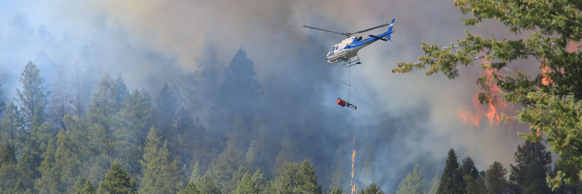
If conditions are right, the prescribed fire will be lit using hand ignition. Sprinklers will create wet lines along the border and roads to contain the fire. Fire crews and helicopters will monitor the area carefully and extinguish any spot fires that occur.
During operations, the public can expect to see flames, smoke, sprinklers, hoses and fire crews working in the area. Helicopter bucketing may also take place. This is all part of normal prescribed fire operations.
How will the public be affected?
Safety is always the top priority for Parks Canada in all fire management operations.
Before and during operations, certain areas will be closed. This includes the Redstreak Restoration Trail, Redstreak Loop, Valleyview Trail and Redstreak Campground Trail. Redstreak Campground will still be closed for the season. For more details and a map of closed areas, visit the Kootenay National Park Important Bulletins webpage.
Parks Canada fire specialists make every effort to limit smoke. The prescribed fire will only go ahead if conditions allow smoke to disperse quickly. However, unpredicted changes in weather can increase and redirect smoke. Be prepared for potential delays and reduced visibility on Highway 95 and Highway 93 South. People with respiratory conditions may be affected.
Vermilion Guard
Date: Spring/Fall
Size: 75 hectares
Location: Near Vermilion Pass, in the northeastern corner of Kootenay National Park.
Additional details: Two large wildfires have burned through Vermilion Pass in the last 50 years. This prescribed fire will create a long-term fire break that helps protect communities in the Bow Valley from wildfires. It will also improve habitat for species at risk like grizzly bears and whitebark pine.
Fire protection and restoration projects in nearby national parks:
Wildfire risk reduction and FireSmart™ projects
Wildfire risk reduction work helps limit fire intensity, reduces the potential for spot fires from windblown embers, and improves the effectiveness of fire suppression techniques. FireSmart™ is a key part of this work.

Did you know: Parks Canada is an active member of the FireSmart™ program. The FireSmart™ program empowers the public and increases community resilience to wildfire across Canada.
The seven FireSmart™ disciplines are the foundation of Parks Canada’s wildfire risk reduction program:
- public education
- emergency planning
- vegetation management
- legislation
- development
- interagency cooperation
- cross-training
Learn more about how you can protect yourself and your community.
Current wildfire risk reduction and FireSmart™ projects:
Dry Gulch open Douglas fir forest restoration and wildfire risk reduction (expected completion Winter 2025)
Annually, between October and March, Parks Canada will be selectively removing and/or limbing vegetation (branches, logs, shrubs) in the Dry Gulch area of southwestern Kootenay National Park.
This is part of a multi-year project to reduce Douglas fir forest encroachment on approximately 800 hectares of grassland ecosystems.
The thinning of dense vegetation helps to reduce wildfire risk and supports habitat restoration for a variety of wildlife species, including Rocky Mountain bighorn sheep. This project contributes to the larger grassland restoration efforts that have been conducted in southern Kootenay National Park such as Sinclair Canyon and Redstreak.
During Fall 2024 operations:
- There are no anticipated impacts to visitors or residents.
- All tree falling will be conducted by hand.
- Woody debris will be piled and burned during winter. Smoke may be visible along Highway 93-95 near Dry Gulch Provincial Park.
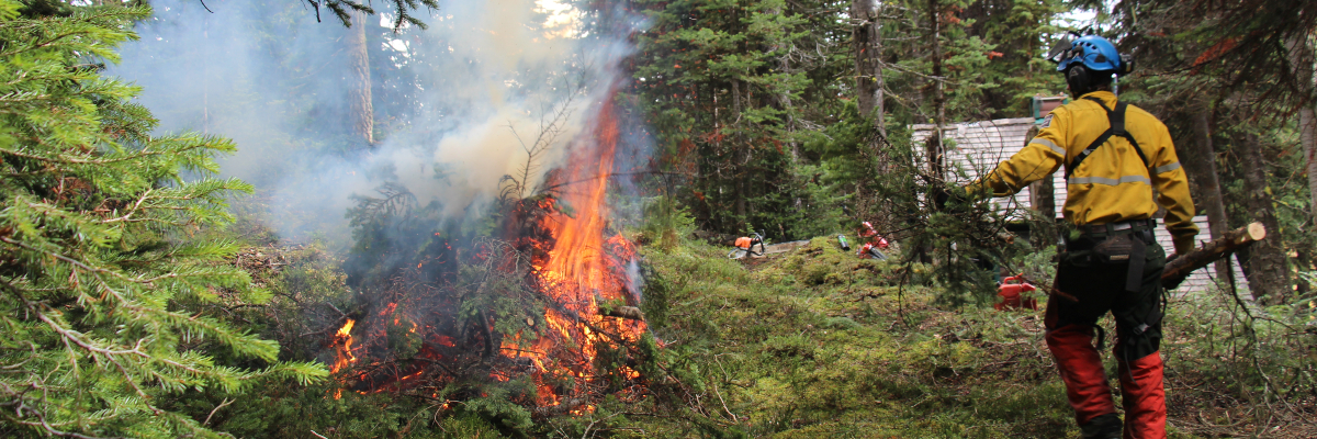
Pile Burning (seasonal, ongoing)
During wildfire risk reduction work, trees, tree limbs, and brush are put into piles. Sometimes these piles of woody debris are too wet, or venting conditions are too poor to burn. These piles are left, and crews return to burn when the piles are dry, and conditions are good.
The piles of woody debris are in different locations around Kootenay National Park.
Burning at each location will only take place when safe to do so and when appropriate venting conditions exist. Visitors and residents can expect to see smoke. Treatment areas will be closed when crews are burning the piles of woody debris. The work will not affect trails, roads, or facilities. Closure details will be posted on site. Please respect all closures and warning signs.
Learn more about Parks Canada's efforts in reducing the risk of wildfires across the country.
Email notification lists
To be added to an email notification list, please contact feullyk-llykfire@pc.gc.ca.
- Smoke notification list: Residents who are sensitive to smoke can receive advance warning of burning.
- Community stakeholders list: Fire information for local organizations and businesses who wish to stay informed about fire operations.
- Date modified :