

Seal River Watershed (Manitoba)
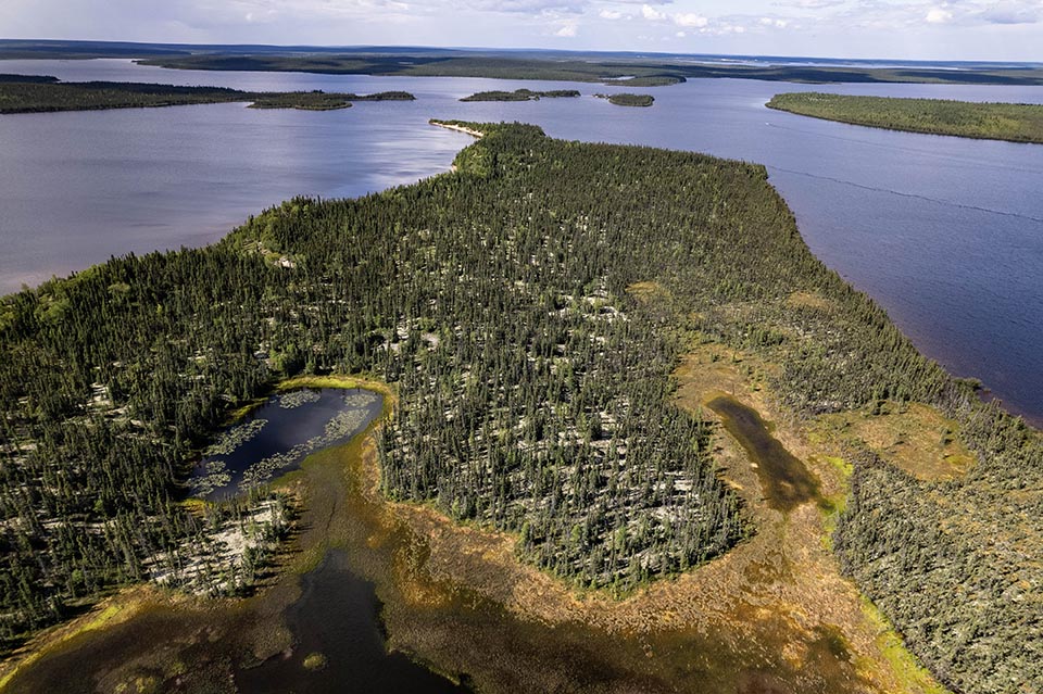
Great news! The Seal River Watershed Alliance and the Governments of Canada and Manitoba have completed the feasibility assessment for the establishment of a protected area including a possible national park reserve and Indigenous protected and conserved area in the Seal River Watershed! The Seal River Watershed in northern Manitoba covers around 50,000 km2. This landscape is one of the world's largest ecologically intact watersheds. The Seal River Watershed is the ancestral territory of many Indigenous nations and communities, including: These First Nations make up the Seal River Watershed Alliance. They collaborate to support the protection of the watershed as an Indigenous Protected and Conserved Area. The cultures and languages of these 4 First Nations are rooted in their relationship to the caribou, moose and fish, and the land and water. Protecting and conserving the watershed means protecting the spirit of their people, who have been stewards of the region since time immemorial. The Alliance envisions an intact watershed where people, animals and fish are healthy. One where the unique languages and cultures are thriving, and there is hope and abundance for all future generations. The Seal River was nominated to the Canadian Heritage River System in 1987 and formally designated a Canadian Heritage River in 1992. This 260 km river is unhindered by dams and industrial development, flowing freely into Hudson Bay. Protecting the Seal River watershed would ensure the land, lakes, rivers and streams from which water flows into the Seal River are protected. There are at least 25 known species at risk within the region. This includes wolverines, polar bears, grizzly bears, barren-ground caribou, and olive-sided flycatchers. A population of harbour seals can be found as far as 200 km inland from the mouth of the Seal River, giving the river its name. Within the Seal River watershed there are large wetland areas that act as carbon “sinks”. These wetlands are important in offsetting the effects of climate change. Carbon sinks absorb carbon dioxide from the atmosphere and store it in trees, soils, mosses, and phytoplankton that live in water. There is no rigid process for establishing new national parks. Each proposed project is unique and reflects local circumstances. The standard sequence, however, is framed by 5 steps. This project is currently at step 4 of 5:On this page
Negotiations for a protected area, including a national park reserve and/or Indigenous protected and conserved area
About the region
A Canadian Heritage River
Nature
Current project stage
Negotiating agreement(s)
-
Completed1 Identify representative natural areas
-
Completed2 Select a potential area
-
Completed3 Assessing the feasibility of a national park, including consultations
-
Current step4 Negotiating agreement(s)
-
5 Establishing a national park under the Canada National Parks Act
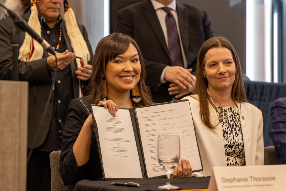
On January 18, 2024 in Winnipeg, Manitoba, the Seal River Watershed Alliance and the Governments of Canada and Manitoba signed a memorandum of understanding (MOU) to formally work together on a feasibility assessment for an Indigenous Protected and Conserved Area (IPCA) and potentially, a national park reserve (NPR), in the Seal River Watershed.
The MOU included a commitment for temporary protection from mineral exploration and staking for the duration of the feasibility assessment. This will help to gain a better understanding of the area’s geological attributes.
The focus of the feasibility assessment stage was to understand the issues and concerns of all interested parties and to identify opportunities and challenges. This was done through an information gathering process that incorporated Traditional Knowledge, science and feedback from public consultations.
-
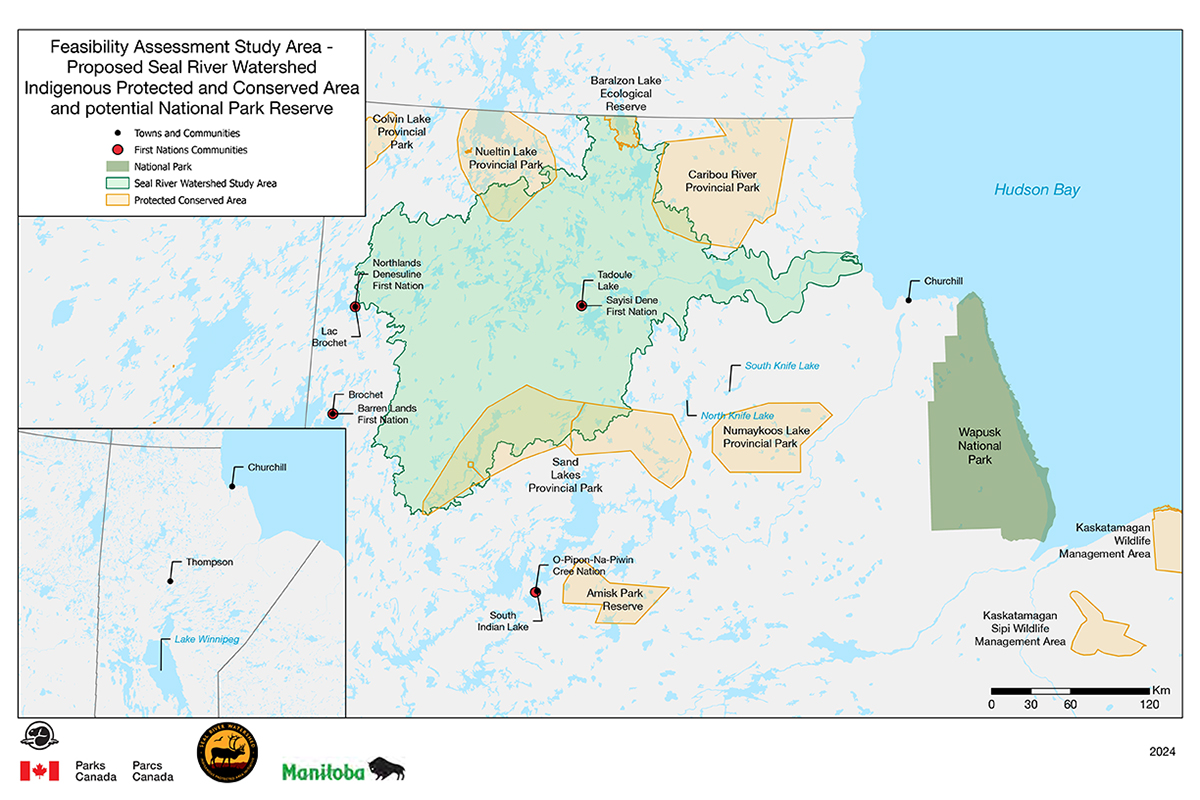
Text version
Seal River Watershed, northern Manitoba.
The map above shows the feasibility assessment study area for the proposed Seal River Watershed protected area in Northern Manitoba.
A legend in the top left corner shows towns and communities marked by a black dot, First Nations Communities with a red dot, National Parks in dark green, the proposed Seal River Watershed Indigenous Protected and Conserved Area and potential national park reserve in light green, and other protected and conserved areas in yellow.
A map insert in the bottom left corner shows where the map is located within Northern Manitoba. It also shows the location of Lake Winnipeg and the Town of Thompson (south of the feasibility assessment study area), and the Town of Churchill (east of the study area). Wapusk National Park is also noted on the banks of the Hudson Bay to the east and southeast of the study area.
A 0–120-kilometer scale bar is located on the bottom right.
The logos for Parks Canada, Seal River Watershed Alliance, and the Government of Manitoba are located below.
The proposed boundary of the Indigenous protected and conserved area and potential national park reserve extends from the Nunavut boarder in the north, to approximately 60 km northwest of the community of South Indian Lake in the south. It also extends west to the town of Lac Brochet and east to the Hudson Bay, including parts of Nueltin Lake Provincial Park in the northwest, Sand Lakes Provincial Park in the south, Baralzon Lake Ecological Reserve in the far north and Caribou River Provincial Park in the northeast. The proposed area also includes Sayisi Dene First Nation and the community of Tadoule Lake. Locations not included within the boundary area are the Town of Brochet and Barren Lands First Nation to the west, the Town of South Indian Lake, and O-Pipon-Na-Piwin Cree Nation in the south, and North Knife Lake, South Knife Lake and the town of Churchill in the east. Colvin Lake Provincial Park to the far north and west, Amisk Park Reserve to the south, Kaskatamagan Sipi Wildlife Management Area to the far south and east, as well as Numaykoos Lake Provincial Park, Wapusk National Park, and Kaskatamagan Wildlife Management Area to the east are also not included within the preposed boundary.
Download the map (PDF, 1.5MB)
What we heard
From July 22 to August 24, 2024, Parks Canada invited partners, stakeholders and the public to provide their input on key aspects for consideration in establishing a national park reserve and/or IPCA in the Seal River Watershed. A summary of the results of the public consultation can be found below.
Consultation report
Timeline and next steps
In March 2025, parties completed the feasibility assessment for the establishment of an Indigenous Protected and Conserved Area and possible national park reserve in the Seal River Watershed. Parties determined that establishing a protected area in the region is both feasible and desired.
Following the feasibility assessment, the next step will be to negotiate an establishment agreement that will outline the development of a protected area(s) proposal. This will include exploring all potential land designations that could support an IPCA, including federal and provincial options.
Negotiation and any subsequent establishment processes will include thorough engagement and consultation with Indigenous communities, stakeholders, and the public.
Working together, the Seal River Watershed Alliance and the Governments of Canada and Manitoba are taking action to protect this iconic natural and cultural landscape for future generations.
- Date modified :