
The formation of the Cape Breton Plateau
Cape Breton Highlands National Park
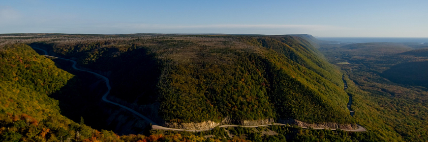
The plateau as we see it today is the product of millions of years of geological change, including mountain building, erosion, and glaciation. Plate tectonics - the movement and collision of continents - has played a major role in forming the highlands through uplift, folding and faulting.
360 to 250 million years ago - Cape Breton Island in the Tropics
Starting about 360 million years ago, the ocean separating Euramerica (EA) from Gondwana slowly closed, bringing these two continents together near the equator. The collision pushed up and folded the seabed along what is now the east coast of North America, creating the Appalachian mountain chain. Faulting and rifting deep in the crust associated with this mountain building is now exposed in many of the canyons that characterize the modern Cape Breton Plateau. Between the up-folded seabed, deep basins were created. Much of the present day Maritime provinces was located in such a basin.
From 340 to 325 million years ago sea level rose and fell, flooding this basin as the ocean closed and giving rise to alternating layers of sedimentary rocks formed from the salts left behind by evaporating water, such as gypsum, and red sandstone, conglomerate and shale. Several gypsum cliffs which can be seen around Dingwall north of the park are relics of this time.
By 325 million years ago, Euramerica and Gondwana were united as the supercontinent Pangea, with the Appalachians running down the seam which joined them. At this time, the Appalachian Mountains were probably higher than the Himalayas are today! Most of the northern Maritimes except for northern Cape Breton Island was lowland covered by a tropical forest swamp which later became coal fields such as those found throughout Cape Breton Island.
About 290 million years ago the climate changed dramatically, putting an end to the tropical forests and replacing them with a brick red desert. There are no rocks of this age in present-day northern Cape Breton Island because the desert didn't extend up into the Appalachian Mountains, but the famous red soil of Prince Edward Island comes from rocks of this period.
250 million years ago to present - the modern world takes shape
By around 250 million years ago the Maritime provinces were joined to what are now Morocco and Spain, at the centre of the Pangean supercontinent. As Pangea started to pull apart, the Maritimes were found on the west side of the slowly spreading Atlantic Ocean, on the edge of a new continent: North America (NA). Erosion, deposition and formation of sedimentary rocks continued along the trailing edge of the North American continent. However, the sedimentary rocks dating from this era all formed to the east on what is now the Scotian Shelf and the Grand Banks, and are submerged.
While dinosaurs probably did walk the hills of northern Cape Breton Island, there is no trace of them because the hills have long since eroded, wearing away any trace of dinosaur bones and footprints. This erosion on the edge of the North American continent cut the whole of Atlantic Canada down to a broad, flat valley. Part of this ancient valley plain is now the flat top of the Cape Breton Plateau.
The last 2 million years - the land where the mountains meet the sea
The Atlantic Ocean continued widening and the North American continent drifted to its present location. It continues to drift an average of a few centimeters a year toward the northwest. Repeated glacial advances - ice ages - through the last two million years and ending about 10,000 years ago caused modifications to the already eroded landscape, carving out U-shaped valleys, shallow lakes, deep scratches called striations, and leaving behind extensive deposits of mixed mud, silt, sand and gravel called glacial till.
The Bras d'Or Lakes were carved out of the bedrock by glaciers during the ice ages. Many other geological and topographical features of Cape Breton Island also owe their form to the numerous glacial advances that occurred over tens of thousands of years.
The glaciers of northern Cape Breton Island were not always part of the continental ice sheet. At times there was only a small ice cap on the highlands, with the rest of northern Cape Breton ice-free.
Even today, populations of Arctic-Alpine and Cordilleran plants can be found in the Cape Breton Highlands, far away from other populations of the same species which are found in northern Canada and the Rocky Mountains. The fact that these types of plants exist here indicates that even during peak glaciation, some land must have remained ice-free on which these plants could grow. These ice-free areas may have been on nunataks (mountain peaks protruding above the glaciers). Another place Arctic-Alpine plants might have survived glaciation is along the coast. During the ice ages, sea levels were about 100 metres lower than they are nowadays because so much water was trapped as ice in the glaciers, so parts of the Scotian Shelf were probably above sea level.
Related links
- Date modified :