History of Kejimkujik Seaside
Kejimkujik National Park and National Historic Site
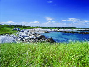
The human history of Kejimkujik Seaside spans as much as 5000 years. Only one object, a spear point, dating to the Late Archaic Period (5000 to 2500 years ago) has been found. It is believed that most of the prehistoric sites occupied by ancestors of the Mi’kmaq have been submerged by the rising waters of the Atlantic Ocean and are now fishing banks. In more recent times, the Mi’kmaq probably used the area of the Kejimkujik Seaside for short hunting and gathering excursions. Mi’kmaq communities were found in what is now Liverpool.
In the summer of 1604, Samuel de Champlain and Pierre Dugua, sieur de Mons camped at Port Mouton. In his map, Champlain describes the Port Mouton area as being: “Open country where grows only shrubs and heaths”. The expedition spent the next summer exploring and mapping the entire coastline. Major settlement efforts by the French were concentrated in the Liverpool area and at Cape Sable. The Seaside seems to have held little interest for the first Europeans. The earliest European settlement at the Seaside, including a free black Loyalist homestead, dates back to the late 18th century Loyalist period. This was in the form of isolated farms along the coast.
Fishing and Farming

Photo: R. Farrell
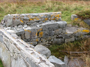
The greatest evidence of the Seaside’s human occupation is from the 19th and early 20th centuries. Several families attempted a mixture of fishing and farming in the area. Parts of the Harbour Rocks Trail follow the old St. Catherine’s River road, shown on maps as early as 1861. That road and other cart tracks connected the small farms along the coast. In a few locations you may discover old stone foundations of houses and farm buildings dating back over 100 years.
A large sheep farm, established by the Kinney family, consolidated many of the smaller farms in the early 20th century into the St. Catherines River Farm. It developed into quite an enterprise with many buildings and up to one thousand grazing sheep. Spruce-fir woodland islands were referred to as a “sheep shelter groves” on the map of the Kinney farm. At MacLeod’s Cove, you will see the foundation of the Cameron house where, around 1912, a Scottish herdsman came with his family to work on the Kinney farm. This farming activity created many enduring environmental changes, including draining saltmarsh portions of the lagoon and clearing land for better sheep pasture. Today, some of the barrens shrub habitat may be regrowth following the clearing.
Little Hope Lighthouse
Offshore you can see Little Hope Island with the remains of the lighthouse which was built there in 1865 and was staffed until 1950. This dangerous coast caused at least five major shipwrecks during the 1800s. Occasionally pottery washes up on the beach from an old shipwreck somewhere just offshore.
In 2003, Hurricane Juan landed on the south shore of Nova Scotia with pounding surf and tidal surges. Little Hope Island’s lighthouse was badly damaged; it toppled after another storm in December, ending 138 years of vigilance.
Keepers of Little Hope lighthouse:
- William Firth (1865-1872)
- Alexander McDonald (1872-1892)
- James Reuben Colp (c. 1912-1922)
- R. Burgess (1920s)
- Allen M. Langille (1928-1945)
- Ernie A. Langille (1945-1947)
- Frank T. Langille (1947)
- O. C. Oickle (1947-1948)
Living with the Atlantic

Rural and coastal communities, including Port Mouton and Port Joli, surround Kejimkujik Seaside. During the summer, visitors may see people engaged in a traditional harvest. Very near the shoreline, in small dories, they use large rakes to bring seaweed into their boats. During the lowest tides of the month, they will be harvesting Irish moss and the more common rockweed at other times. Caragheenan is extracted from these seaweeds and used as emulsifiers or thickening agents in the preparation of such products as toothpaste and chocolate milk. Liquid plant fertilizers are also produced.
- Date modified :