
Fire information archives
Prince Albert National Park
This section contains an archive of fire information updates released by Parks Canada during the Rabbit Creek Wildfire.
Tuesday, May 8, 2018
Wasstrom's Flats fire
Parks Canada is currently managing a wildfire that is inside the southwest corner of the park. It is approximately 1,000 hectares.
An area closure is in place that includes Hunters Lake Trail, the Valleyview Trail Network and all area between them. Please see the map under the Area Closure on the Important Bulletins.
Updates on the Important Bulletins will occur once per day until the fire is extinguished or if there is a significant change.
Resources:
- 25 wildland firefighters from Prince Albert, Grasslands and Pukaskwa national parks
- 4 helicopters with water buckets
- 10 firefighters from Saskatchewan Environment, Wildfire Management Branch are en route
- A Parks Canada national incident management team is en route
Background:
Fire crews have been working in southwest corner of Prince Albert National Park since May 3, 2018, to carry out a prescribed fire to restore rare fescue grasslands. Part of the process is to burn a control line around the area being targeted to contain it. While carrying out this work on May 6, they encountered wind significantly higher than forecasted that caused the fire to spot outside of the control line perimeter.
Crews are on site along with four helicopters to manage the situation and are expecting more resources from both Saskatchewan Environment’s Wildfire Management Branch and other Parks Canada national parks.
Because the location is close to the southern boundary of the park, all available resources are being deployed to ensure that the fire is managed and does not leave the park. The exact location is about 40 km southwest of the townsite, so there are no concerns for Waskesiu or areas around the South Gate entrance.
Shannon Bond
Fire Information Officer
Shannon.bond@pc.gc.ca
306-314-0726
Wednesday, May 9, 2018
Update on Wasstrom's Flats Fire
The fire was held inside the park along the south boundary during strong NE wind on May 7. A control line along the south boundary of the park will continue to be monitored and any hot spots or fires found adjacent to the control lines will be extinguished.
Yesterday, the wind switched and blew out of the south so active fire that remains in the area is burning into the park and away from any values.
Cooler weather and favourable winds over the next couple of days provide the opportunity to construct additional control lines in the Millard prescribed fire unit. Smoke may be seen as the control lines are constructed and fuels within the fire continue to burn.
The Millard unit was also scheduled for a prescribed fire this spring as a landscape disturbance to renew old coniferous forest (trees with needles) and reduce the encroachment of aspen into small grasslands found in the area.
Resources on the Wasstrom's Flats fire include:
- 15 wildland firefighters from Prince Albert, Grasslands and Pukaskwa national parks
- 10 firefighters through Saskatchewan Environment, Wildfire Management
- 1 helicopter with a water bucket
- A Parks Canada national incident management team
We continue to work with provincial partners and local agencies to ensure that information is being shared with affected community members.
Daily updates will be provided until the fire is extinguished or more often if there is a significant change.
Shannon Bond
Fire Information Officer
Shannon.bond@pc.gc.ca
306-314-0726
Thursday, May 10, 2018
Update on Wasstrom's Flats Fire and Millard Fire
A control line along the south boundary of the park will continue to be monitored and any hot spots or fires found adjacent to the control lines will be extinguished.
The current objective is to conduct burning in the Millard prescribed fire unit to remove volatile fuels in order to better control and suppress active fire. Smoke may be seen as the control lines are constructed and fuels continue to burn.
The Millard unit was scheduled for a prescribed fire this spring as a landscape disturbance to renew old coniferous forest (trees with needles) and reduce the encroachment of aspen into small grasslands found in the area.
We continue to work with provincial partners and local agencies to ensure that information is being shared.
Further updates will not be provided unless there is a significant change.
Catharine Brazeau
Information Officer
587-340-3460
Monday, May 14, 2018
Update on Fire in Prince Albert National Park
Work on the prescribed fire in the southwest corner of Prince Albert National Park continues. Fire activity on the south and west boundaries of the park continues to be managed. Crews are patrolling on the ground and helicopters are dropping buckets of water as required; any hot spots or fires found adjacent to control lines will be extinguished. Changing winds may result in increased smoke over the next few days, and smoke columns from prescribe burns may be visible.
The risk of wildfire is high, and a fire ban has been implemented throughout Prince Albert National Park. For further information see the important bulletins page. Call 9-1-1 if you see fire on your personal property.
There is smoke throughout the area, particularly toward the southwest corner of Prince Albert National Park. Parks Canada encourages visitors and residents to check weather and air quality advisories.
Prince Albert National Park is open. For the latest information on area closures see the important bulletins page. Current closures include:
- Elk Trail
- Valleyview Trail Network
- Amyot Lake Trail Spur
- Hunter’s Lake Trail
- Camp Lake campground
- Fish Lake campground
- Cookson Road on the south boundary of Prince Albert National Park west of Mayview Road to the park boundary
We continue to work with provincial partners and local agencies to ensure that information is being shared with affected community members.
Updates will be provided if there are notable changes.
Catharine Brazeau
Information Officer
587-340-3460
Tuesday, May 15, 2018
Update on Fire in Prince Albert National Park
IMPORTANT BULLETIN – This product is intended for are website, primarily to keep general audiences (visitors, neighbours) updated.
Fire activity on the south and west boundaries of the park continues to be managed. Crews are patrolling on the ground and helicopters are dropping buckets of water as required; any hot spots or fires found adjacent to control lines will be extinguished. Changing winds may result in increased smoke over the next few days, and smoke columns from fire may be visible.
There is smoke throughout the area, particularly toward the southwest corner of Prince Albert National Park. Parks Canada encourages visitors and residents to check weather and air quality advisories at weather.gc.ca. A map showing the smoke forecast can also be found here: http://firesmoke.ca/forecasts/viewer/run/ops/BSC-WC-01/current/
The Canadian Wildland Fire Information System website (http://cwfis.cfs.nrcan.gc.ca/interactive-map) provides estimates of the fire perimeter.
Nearby residents are encouraged to refer to their jurisdiction’s administrations for information related to local fire bans, evacuation alerts, and evacuation orders.
The risk of wildfire is high, and a fire ban has been implemented throughout Prince Albert National Park. For further information see the important bulletins page at ParksCanada.gc.ca/PrinceAlbert. Call 9-1-1 if you see fire on your personal property.
Prince Albert National Park is open. For the latest information on area closures see the important bulletins page at ParksCanada.gc.ca/PrinceAlbert
Current closures include:
- Elk Trail
- Valleyview Trail Network
- Amyot Lake Trail Spur
- Hunter’s Lake Trail
- Camp Lake campground
- Fish Lake campground
- Cookson Road on the south boundary of Prince Albert National Park west of Mayview Road to the park boundary
We continue to work with provincial partners and local agencies to ensure that information is being shared with affected community members. Updates will be provided if there are notable changes.
Updates will be provided if there are notable changes.
panp.info@pc.gc.ca
1-888-773-8888
Wednesday, May 23, 2018
Rabbit Creek Wildfire. Update: May 23, 2018
Parks Canada continues to manage the Rabbit Creek wildfire in Prince Albert National Park. We are currently directly and indirectly attacking the fire with helicopter bucketing, water tankers, heavy equipment and on-the-ground fire fighters. The ongoing dry and warm weather conditions are contributing to increased fire activity and significant smoke in the area.
What you need to know
- Additional area closures are in effect due to the risk associated with extreme fire danger and smoke but not fire activity at this time.
- Parks Canada maintains the capability to respond to all new fire starts in the national parks, with initial attack crews and helicopters. Additional resources can also be brought in as required.
- As a precautionary measure, facility and infrastructure protection and fuel management actions are being implemented in and around the townsite of Waskesiu.
- Residents of nearby rural municipalities (RM) are strongly encouraged to contact their RM administration offices for information on evacuation alerts or orders in their area.
- A fire ban is in effect for Prince Albert National Park due to extreme fire danger.
What is open?
- All services within the Town of Waskesiu.
- Highway 264 in Prince Albert National Park remains open.
- The Hanging Heart Lakes and Crean Lake remain open for day use boating (no overnight).
- Boundary Bog, Red Deer Trail Network, Waskesiu River and Fisher Trail
Quick facts
Location: Primarily within Prince Albert National Park, with some spotting to the south and west of the park boundaries on provincial lands
Size (approx.): 29,600 hectares
Resources: All available resources have been deployed to this incident.
- 13 helicopters
- 2 water tankers
- 5 pieces heavy equipment
- 184 fire fighters from AB, SK, ONT, QC and NWT and Parks Canada field units
- Facility protection teams
More information: Email the Fire Information Officer at panp.fire@pc.gc.ca.
Map
-
Map of the Rabbit Creek Fire as of May 23, 2018.

We now estimate that the wildfire now covers an area of approximately 29,600 hectares . -
Closures map of the Rabbit Creek Fire as of May 23, 2018

Thursday, May 24, 2018
Rabbit Creek Wildfire. Update: May 24, 2018
Parks Canada continues to manage Rabbit Creek wildfire in Prince Albert National Park with helicopter bucketing, water tankers, heavy equipment and on-the-ground fire fighters. The ongoing dry and warm weather conditions are contributing to increased fire activity and significant smoke in the area.
Current priorities
- Continuing to extinguish hotpots in the community pasture south near the park boundary, and priority areas on the east and west sides using ground crews and heavy equipment, with support from helicopter bucketing and air tankers;
- Planning and undertaking containment options on the fire’s north end;
- Maintaining preparedness to respond to new fires in the park; and
- Working to reduce the risk of wildfire to the community by removing fuels around buildings and installing sprinkler systems in and around the townsite of Waskesiu.
What you need to know
- Area closures are in effect due to the risk associated with extreme fire danger and smoke but not fire activity at this time.
- Residents of nearby rural municipalities (RM) are strongly encouraged to contact their RM administration offices for information on evacuation alerts or orders in their area.
- A fire ban is in effect for Prince Albert National Park due to extreme fire danger.
Quick facts
Location: Primarily within Prince Albert National Park.
Size (approx.): 31,400 hectares
Resources: All available resources have been deployed to this incident.
- 13 helicopters
- 2 water tankers
- 5 pieces heavy equipment
- 187 personnel with fire fighters from AB, SK, ONT, QC and Parks Canada
- Facility protection teams
More information: Email the Fire Information Officer at panp.fire@pc.gc.ca.
Map
-
Map of the Rabbit Creek Fire as of May 24, 2018.
We now estimate that the wildfire now covers an area of approximately 31,400 hectares . -
Closures map of the Rabbit Creek Fire as of May 24, 2018
Friday, May 25, 2018
Rabbit Creek Wildfire. Update: May 25, 2018
Parks Canada and a wide range of provincial and community partners continue to manage Rabbit Creek wildfire in Prince Albert National Park with helicopter bucketing, air tankers, heavy equipment and on-the-ground fire fighters.
Precipitation is making it possible for ground crews to access more areas of the fire. The fire has not grown significantly since May 21.
What you need to know
- Area closures are in effect due to the risk associated with smoke and an extreme fire danger rating but not fire activity at this time.
- Residents of nearby rural municipalities (RM) are strongly encouraged to contact their RM administration offices for information on evacuation alerts or orders in their area.
- Call 9-1-1 for emergencies. Call FireWatch 1(800) 667-9660 to report wildfires.
Current priorities
- The park’s south boundary is contained and crews continue to monitor and put out any remaining hotpots;
- Crews and heavy equipment are creating control lines on the east and west sides of the fire and are being supported by helicopters with buckets;
- Preparedness to respond to new fires in the park is maintained;
- Fuels around buildings are being thinned or removed and sprinkler systems in and around the townsite of Waskesiu installed.
- Parks Canada is working with provincial partners to ensure communities adjacent to the park are also being assessed for risk and protected as required.
Quick facts
Location: Primarily within Prince Albert National Park.
Size (approx.): 35,416 hectares
Resources: All required resources have been deployed to this incident.
- 13 helicopters
- 2 water tankers
- 5 pieces heavy equipment
- 187 personnel with fire fighters from AB, SK, ONT, QC and Parks Canada
- Facility protection teams
More information: Email the Fire Information Officer at panp.fire@pc.gc.ca.
Map
-
Map of the Rabbit Creek Fire as of May 25, 2018.

We now estimate that the wildfire now covers an area of approximately 35,416 hectares . -
Closures map of the Rabbit Creek Fire as of May 25, 2018
Saturday, May 26, 2018
Rabbit Creek Wildfire. Update: May 26, 2018
Parks Canada and a wide range of provincial and community partners continue to manage Rabbit Creek wildfire in Prince Albert National Park.
Between 4mm of rain near Waskesiu townsite and 55mm on the southeast part of the fire fell in the last 24 hours. Precipitation is making it possible for ground crews to work safely on more areas of the fire. The fire has not grown significantly since May 21.
What you need to know
- Area closures are still in effect.
- Waskesiu townsite and trails, as well as day-use of Waskesiu, Hanging Hearts and Crean lakes are open to enjoy.
- Residents of nearby rural municipalities (RM) are strongly encouraged to contact their RM administration offices for information on evacuation alerts or orders in their area.
- Call 9-1-1 for emergencies. Call FireWatch 1(800) 667-9660 to report wildfires.
Current priorities
- Fire along and adjacent to the park’s south boundary is contained and will be patrolled;
- Fire crews and heavy equipment are creating control lines on the east and west sides of the fire and are being supported by helicopters with buckets;
- Preparedness to respond to new fires in the park is maintained;
- Preparedness to respond to new fires in the park is maintained;
- Fuels around buildings are being thinned or removed and sprinkler systems in and around the townsite of Waskesiu installed.
- Parks Canada is working with provincial partners to ensure communities adjacent to the park are also being assessed for risk and protected as required.
Quick facts
Location: Primarily within Prince Albert National Park.
Size (approx.): 35,416 hectares
Resources: All required resources have been deployed to this incident.
- 9 helicopters
- 10 pieces heavy equipment
- 210 personnel with fire fighters from AB, ONT, QC and Parks Canada
- Facility protection teams
More information: Email the Fire Information Officer at panp.fire@pc.gc.ca.
Map
-
Map of the Rabbit Creek Fire as of May 26, 2018.
We now estimate that the wildfire now covers an area of approximately 35,416 hectares . -
Closures map of the Rabbit Creek Fire as of May 26, 2018
Sunday, May 27, 2018
Rabbit Creek Wildfire. Update: May 27, 2018
Favourable weather has enabled fire personnel to make progress on containing Rabbit Creek Wildfire in Prince Albert National Park.
Precipitation continues to fall across the fire in varying amounts making it possible for ground crews to work safely on more remote areas of the fire.
A warm, windy, drying trend may cause smoke to be visible again this week.
What you need to know
- Area closures are still in effect and will be assessed daily.
- Waskesiu townsite and trails, as well as day-use of Waskesiu, Hanging Hearts and Crean lakes are open to enjoy.
- Call 9-1-1 for emergencies. Call FireWatch 1(800) 667-9660 to report wildfires.
Current priorities
- Fire crews and heavy equipment continue to create control lines on the east and west sides of the fire and are being supported by helicopters with buckets;
- Patrol the park’s south boundary to ensure containment is secure;
- Preparedness to respond to new fires in the park is maintained;
- Fuels around buildings are being thinned or removed and sprinkler systems in and around the townsite of Waskesiu are tested.
Quick facts
Location: Primarily within Prince Albert National Park.
Size (approx.): 35,600 hectares
Resources: All required resources have been deployed to this incident.
- 9 helicopters
- 10 pieces heavy equipment
- 210 personnel with fire fighters from AB, ONT, QC and Parks Canada
- Facility protection teams
More information: Email the Fire Information Officer at panp.fire@pc.gc.ca.
Map
-
Map of the Rabbit Creek Fire as of May 27, 2018.

We now estimate that the wildfire now covers an area of approximately 35,600 hectares. -
Closures map of the Rabbit Creek Fire as of May 27, 2018
Monday, May 28, 2018
Rabbit Creek Wildfire. Update: May 28, 2018
Parks Canada continues to manage the Rabbit Creek wildfire in Prince Albert National Park.
While the precipitation in the region has lowered the fire danger, the fire is not yet fully contained. The burned fire area is approximately 35,600 hectares.
The risk to the Waskesiu townsite and nearby communities has decreased significantly, but residents should continue the proactive FireSmart work around their residences.
A fire ban remains in effect in Prince Albert National Park to prevent the possibility of human-caused fires.
A warm, windy, drying trend may cause smoke to be visible again early this week.
What you need to know
- Area closures are still in effect and will be assessed daily.
- Waskesiu townsite and trails, as well as day-use of Waskesiu, Hanging Hearts and Crean lakes are open to enjoy.
- Call 9-1-1 for emergencies. Call FireWatch 1(800) 667-9660 to report wildfires.
Current priorities
- Fire crews and heavy equipment continue to create control lines on the east, west and north sides of the fire, and are being supported by helicopters with buckets;
- Patrol the park’s south boundary to ensure containment is secure;
- Preparedness to respond to new fires in the park is maintained;
Quick facts
Location: Primarily within Prince Albert National Park.
Size (approx.): 35,600 hectares
Resources: All required resources have been deployed to this incident.
- 9 helicopters
- 10 pieces heavy equipment
- 238 personnel with fire fighters from AB, SK, ONT, QC and Parks Canada
- Facility protection teams
More information: Email the Fire Information Officer at panp.fire@pc.gc.ca.
Map
-
Map of the Rabbit Creek Fire as of May 28, 2018.
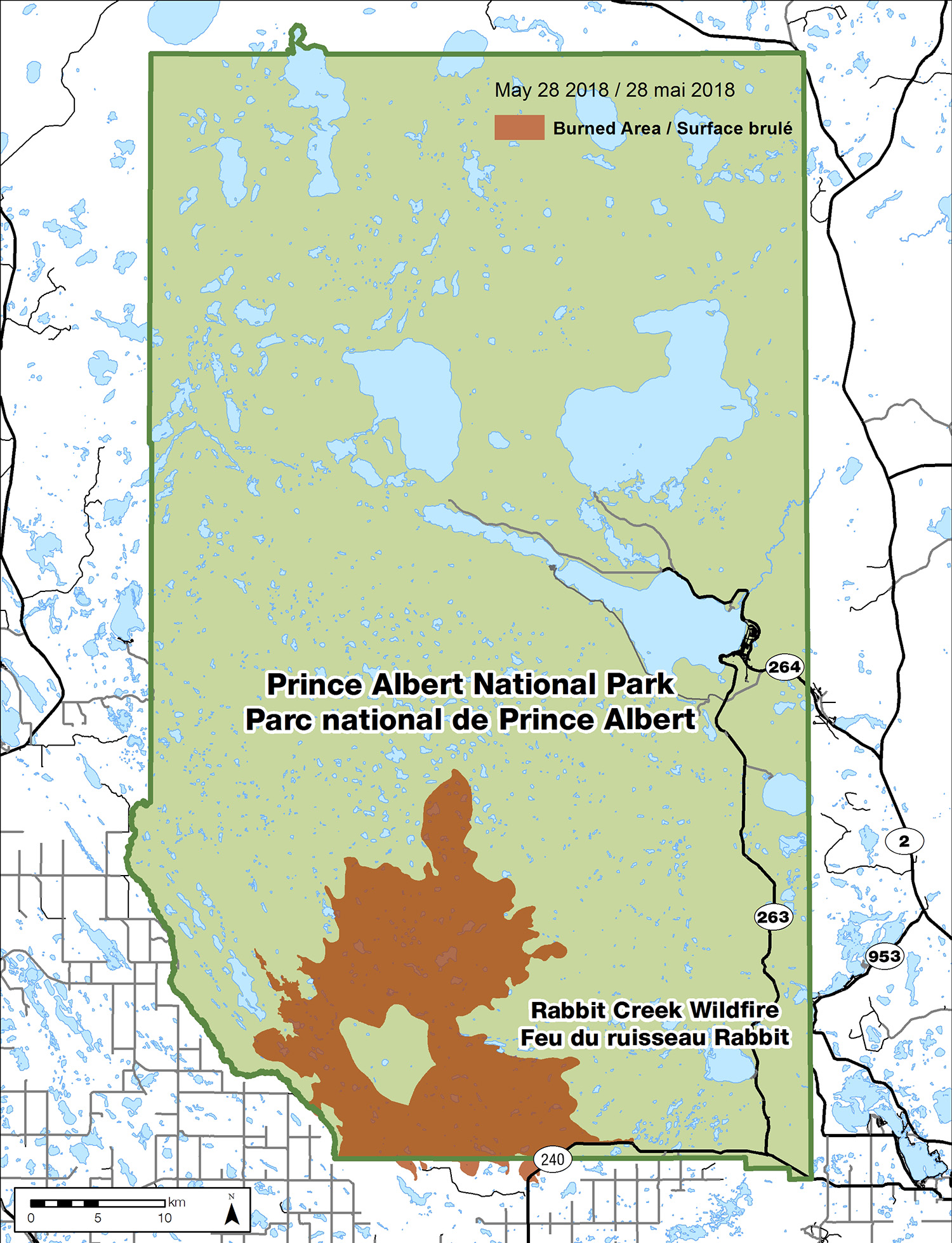
We now estimate that the wildfire now covers an area of approximately 35,600 hectares. -
Closures map of the Rabbit Creek Fire as of May 28, 2018
Tuesday, May 29, 2018
Rabbit Creek Wildfire. Update: May 29, 2018
Parks Canada and our partner agencies continue to manage the Rabbit Creek wildfire in Prince Albert National Park.
While the precipitation in the region has lowered the fire danger, the fire is not yet fully contained.
The Waskesiu townsite, including campgrounds, remains open. The risk to the townsite and nearby communities has decreased significantly, but residents should continue the proactive FireSmart work around their residences.
What you need to know
Recent precipitation and progress made to contain the fire make it possible to lift some area closures.
Beginning Wednesday, May 30, the following areas will be open:
- Highway 263 including trails and campgrounds.
- The North Shore road to Kingsmere Lake, all trails, campgrounds, and backcountry areas.
- Hanging Heart and Crean lakes including campgrounds.
Closures of the Narrows Road and west side of the park including Elk Trail are still in place.
Current priorities
- Fire crews and heavy equipment continue to create control lines on the east, west and north sides of the fire, and are being supported by helicopters with buckets;
- Patrol the park’s south boundary to ensure containment is secure;
- Preparedness to respond to new fires in the park is maintained.
Quick facts
Location: Primarily within Prince Albert National Park.
Size (approx.): 35,600 hectares
Resources: All required resources have been deployed to this incident.
- 9 helicopters
- 4 pieces heavy equipment
- 223 personnel with fire fighters from BC, AB, SK, ONT, QC and Parks Canada
- Facility protection teams
More information: Email the Fire Information Officer at panp.fire@pc.gc.ca.
Map
-
Map of the Rabbit Creek Fire as of May 29, 2018.
We now estimate that the wildfire now covers an area of approximately 35,600 hectares. -
Closures map of the Rabbit Creek Fire as of May 29, 2018
Wednesday, May 30, 2018
Rabbit Creek Wildfire. Update: May 30, 2018
Parks Canada and our partner agencies continue to manage the Rabbit Creek wildfire in Prince Albert National Park.
While the fire is not yet fully contained, precipitation in the region, and progress to contain the fire has lowered the fire danger making it possible to open more areas of the park.
The risk to the Waskesiu townsite and nearby communities has decreased significantly, but residents should continue the proactive FireSmart work around their residences.
Cooler temperatures and unsettled conditions are expected in the area of the fire for the next few days.
What you need to know
The following areas of the park are open:
- Waskesiu townsite – including campgrounds.
- Highway 263 including trails and campgrounds.
- The North Shore road to Kingsmere Lake, all trails, campgrounds and backcountry.
- Hanging Heart and Crean lakes including campgrounds.
Closures of the Narrows Road and west side of the park including Elk Trail are still in place.
Current priorities
- Fire crews and heavy equipment continue to create control lines on the west and north sides of the fire, and are being supported by helicopters with buckets;
- Patrol the park’s south boundary and East division to ensure containment is secure;
- Preparedness to respond to new fires in the park is maintained.
Quick facts
Location: Primarily within Prince Albert National Park.
Size (approx.): 36,665 hectares
Resources: All required resources have been deployed to this incident.
- 10 helicopters
- 4 pieces heavy equipment
- 211 personnel with fire fighters from BC, AB, SK, ONT, QC and Parks Canada
- Facility protection teams
More information: Email the Fire Information Officer at panp.fire@pc.gc.ca.
Map
-
Points of active fire as of May 30, 2018.

How to interpret this map of Rabbit Creek Wildfire:
- The colours that make up the fire’s area burned represent its growth from May 8 through May 23. The fire perimeter has not grown significantly since then and fire personnel are extinguishing the fire 30 m (100 ft) in from the perimeter.
Smoke may be visible over the coming weeks as islands of unburned vegetation deep within the fire unit ignite and burn out. Other pockets of unburned vegetation will survive and are called fire refugia. They represent important safe havens for plants and animals. - The black stars represent points of fire activity that are detected through remote infrared imaging done early in the morning. A helicopter flies over the fire and uses GPS to mark any areas that are still have active fire. Crews will go back and extinguish those areas from the ground and by air.
- The arrows indicate distance between the fire and communities. Vegetation types, topography and weather become important factors in determining how quickly fire might spread and varies from one day to the next.
Deciduous trees such as birch and aspen, and understory vegetation like hazel that have leafed out burn more slowly than conifers such as pine and spruce. Those deciduous trees, which make up much of the mixed wood forest found between the fire and communities, in addition to wetlands and recent precipitation all work to slow a fire’s progression.
- The colours that make up the fire’s area burned represent its growth from May 8 through May 23. The fire perimeter has not grown significantly since then and fire personnel are extinguishing the fire 30 m (100 ft) in from the perimeter.
-
Map of the Rabbit Creek Fire as of May 30, 2018.
We now estimate that the wildfire now covers an area of approximately 36,665 hectares. -
Closures map of the Rabbit Creek Fire as of May 30, 2018

Thursday, May 31, 2018
Rabbit Creek Wildfire. Update: May 31, 2018
Parks Canada and our partner agencies continue to manage the Rabbit Creek wildfire in Prince Albert National Park.
While the fire is not yet fully contained, precipitation in the region, and progress of fire crews has lowered the fire danger to low making it possible to open more areas of the park.
Cooler temperatures and unsettled conditions are expected in the area of the fire for the next few days.
What you need to know
The following areas of the park are open:
- Waskesiu townsite – including campgrounds.
- Highway 263 including trails and campgrounds.
- The North Shore road to Kingsmere Lake, all trails, campgrounds and backcountry.
- Hanging Heart and Crean lakes including campgrounds.
As of Friday, June 1, the following areas of the park will open:
- the Narrows Road day use areas, trails and campground
Closures remain in place for:
- Hunters Lake Trail
- Cookson Road from the south boundary of Prince Albert National Park by the Cookson Pasture to Mayview Road
Current priorities
- Fire crews continue to create control lines on the north side of the fire, with heavy equipment on the west side of the fire and are being supported by helicopters;
- Fire crews are patrolling the park’s south boundary and east division to ensure containment is secure.
Quick facts
Location: Primarily within Prince Albert National Park.
Size (approx.): 36,665 hectares
Resources: All required resources have been deployed to this incident.
- 8 helicopters
- 4 pieces heavy equipment
- 211 personnel with fire fighters from BC, AB, SK, ONT, QC and Parks Canada
- Facility protection teams
More information: Email the Fire Information Officer at panp.fire@pc.gc.ca.
Map
-
Points of active fire as of May 31, 2018.
How to interpret this map of Rabbit Creek Wildfire:
- The colours that make up the fire’s area burned represent its growth from May 8 through May 23. The fire perimeter has not grown significantly since then and fire personnel are extinguishing the fire 30 m (100 ft) in from the perimeter.
Smoke may be visible over the coming weeks as islands of unburned vegetation deep within the fire unit ignite and burn out. Other pockets of unburned vegetation will survive and are called fire refugia. They represent important safe havens for plants and animals. - The black stars represent points of fire activity that are detected through remote infrared imaging done early in the morning. A helicopter flies over the fire and uses GPS to mark any areas that are still have active fire. Crews will go back and extinguish those areas from the ground and by air.
- The arrows indicate distance between the fire and communities. Vegetation types, topography and weather become important factors in determining how quickly fire might spread and varies from one day to the next.
Deciduous trees such as birch and aspen, and understory vegetation like hazel that have leafed out burn more slowly than conifers such as pine and spruce. Those deciduous trees, which make up much of the mixed wood forest found between the fire and communities, in addition to wetlands and recent precipitation all work to slow a fire’s progression.
- The colours that make up the fire’s area burned represent its growth from May 8 through May 23. The fire perimeter has not grown significantly since then and fire personnel are extinguishing the fire 30 m (100 ft) in from the perimeter.
-
Map of the Rabbit Creek Fire as of May 31, 2018.
We now estimate that the wildfire now covers an area of approximately 36,665 hectares. -
Closures map of the Rabbit Creek Fire as of May 31, 2018
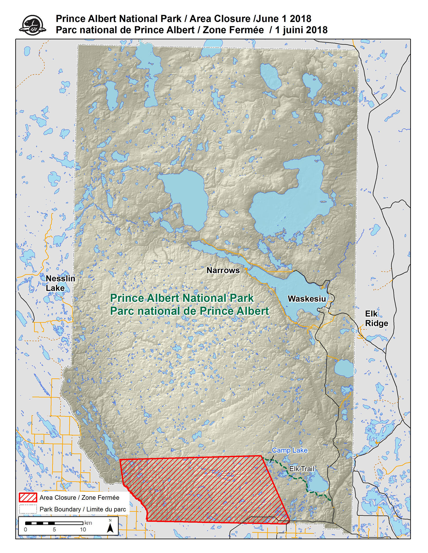
Friday, June 1, 2018
Rabbit Creek Wildfire. Update: June 1, 2018
Rabbit Creek Wildifre is now ‘being held’ – not extinguished but no longer growing - as a result of precipitation, cool weather and efforts by fire personnel. As such, partner agencies will be released over the next two days and Parks Canada will continue to patrol the fire perimeter for remaining hotspots.
Parks Canada is grateful to its many community partners, Saskatchewan Emergency Management Organization, Saskatchewan Environment Resource Management, and the assistance of AB, SK, ON, NWT, QC, and the Canadian Forestry Service provided through the Canadian Interagency Forest Fire Centre mutual aid agreement.
Further updates on Rabbit Creek Wildfire will only occur if there is a significant change.
What you need to know
Most areas of Prince Albert National Park are open including Waskesiu.
Closures remain in place for:
- Hunters Lake Trail
- Cookson Road from the south boundary of Prince Albert National Park by the Cookson Pasture to Mayview Road
Current priorities
- Fire crews will continue to patrol the fire’s perimeter and extinguish hotspots with support from a helicopter with water bucket;
- Work will be done to further strengthen the Waskesiu Community Fuel Break.
- Equipment is being removed from the fireline.
Quick facts
Location: Primarily within Prince Albert National Park.
Size (approx.): 36,665 hectares
Resources: All required resources have been deployed to this incident.
- 4 helicopters
- 3 pieces heavy equipment
- 121 personnel with fire fighters from SK, ONT, QC and Parks Canada
More information: Email the Fire Information Officer at panp.fire@pc.gc.ca.
Map
-
Points of active fire as of June 1, 2018.
How to interpret this map of Rabbit Creek Wildfire:
- The colours that make up the fire’s area burned represent its growth from May 8 through May 23. The fire perimeter has not grown significantly since then and fire personnel are extinguishing the fire 30 m (100 ft) in from the perimeter.
Smoke may be visible over the coming weeks as islands of unburned vegetation deep within the fire unit ignite and burn out. Other pockets of unburned vegetation will survive and are called fire refugia. They represent important safe havens for plants and animals. - The black stars represent points of fire activity that are detected through remote infrared imaging done early in the morning. A helicopter flies over the fire and uses GPS to mark any areas that are still have active fire. Crews will go back and extinguish those areas from the ground and by air.
- The arrows indicate distance between the fire and communities. Vegetation types, topography and weather become important factors in determining how quickly fire might spread and varies from one day to the next.
Deciduous trees such as birch and aspen, and understory vegetation like hazel that have leafed out burn more slowly than conifers such as pine and spruce. Those deciduous trees, which make up much of the mixed wood forest found between the fire and communities, in addition to wetlands and recent precipitation all work to slow a fire’s progression.
- The colours that make up the fire’s area burned represent its growth from May 8 through May 23. The fire perimeter has not grown significantly since then and fire personnel are extinguishing the fire 30 m (100 ft) in from the perimeter.
-
Map of the Rabbit Creek Fire as of June 1, 2018.
We now estimate that the wildfire now covers an area of approximately 36,665 hectares. -
Closures map of the Rabbit Creek Fire as of June 1, 2018
Thursday, June 21, 2018
Rabbit Creek Wildfire. Update: June 21, 2018
Rabbit Creek Wildifre is now ‘being held’ – not extinguished but not expected to grow with the current weather forecast and assigned fire personnel. Parks Canada will continue to patrol the fire perimeter for remaining hotspots.
There will be no further updates on Rabbit Creek Wildfire unless there are significant changes.
Prince Albert National Park is open, trails are in good condition and businesses in Waskesiu look forward to another busy season.
The fire ban for Prince Albert National Park has been lifted.
What you need to know
- There is no risk from Rabbit Creek Wildfire to people in Prince Albert National Park.
- Smoke may be visible over the coming weeks as pockets of vegetation deep within the fire area burn, but it will be short-lived and should not affect the quality of peoples’ visit.
Closures remain in place for:
- Hunters Lake Trail
- Cookson Road from the south boundary of Prince Albert National Park by the Cookson Pasture to Mayview Road.
Current priorities
- Fire crews will continue to patrol the fire’s perimeter and extinguish hotspots with support from a helicopter with water bucket
Parks Canada wishes to thank all of the community partners, contractors, provincial emergency management organizations and wildland firefighting agencies from across Canada who assisted in managing Rabbit Creek Wildfire. Have a safe and enjoyable summer!
Map
-
Points of active fire as of June 4, 2018.
How to interpret this map of Rabbit Creek Wildfire:
- The colours that make up the fire’s area burned represent its growth from May 8 through May 23. The fire perimeter has not grown significantly since then and fire personnel are extinguishing the fire 30 m (100 ft) in from the perimeter.
Smoke may be visible over the coming weeks as islands of unburned vegetation deep within the fire unit ignite and burn out. Other pockets of unburned vegetation will survive and are called fire refugia. They represent important safe havens for plants and animals. - The black stars represent points of fire activity that are detected through remote infrared imaging done early in the morning. A helicopter flies over the fire and uses GPS to mark any areas that are still have active fire. Crews will go back and extinguish those areas from the ground and by air.
- The arrows indicate distance between the fire and communities. Vegetation types, topography and weather become important factors in determining how quickly fire might spread and varies from one day to the next.
Deciduous trees such as birch and aspen, and understory vegetation like hazel that have leafed out burn more slowly than conifers such as pine and spruce. Those deciduous trees, which make up much of the mixed wood forest found between the fire and communities, in addition to wetlands and recent precipitation all work to slow a fire’s progression.
- The colours that make up the fire’s area burned represent its growth from May 8 through May 23. The fire perimeter has not grown significantly since then and fire personnel are extinguishing the fire 30 m (100 ft) in from the perimeter.
-
Map of the Rabbit Creek Fire as of June 4, 2018.
We now estimate that the wildfire now covers an area of approximately 36,665 hectares. -
Closures map of the Rabbit Creek Fire as of June 4, 2018
- Date modified :