
Thechàl Dhâl (Sheep Mountain) Ridge
Kluane National Park and Reserve
To protect the Dall’s sheep in Kluane National Park and Reserve, please choose not to hike the Thechàl Dhâl' ridge route during lambing season (May 1 to June 15).
Distance: 11 km (7 mi) loop
Time: 6-10 hrs
Elevation gain: 1,310 m (4,300')
Maximum elevation: 1,922 m (6,300')
Trailhead: At the boat launch 2.9 km/1.8 mi north of the Thechàl Dhâl Visitor Centre (73.6 km/45.7 mi north of Haines Junction) on the Alaska Highway.
Topo map: Destruction Bay 115 G/2
In summary
This is a long challenging day hike (1310 m/4300 ft elevation gain over the first 2.5 km/1.5 mi), which involves some steep off trail travel. It offers hikers spectacular panoramic vistas and excellent wildlife viewing opportunities.
The route connects the Thechàl Dhâl (Sheep Mountain) Northeast Ridge Route and the Sheep Creek Trail. It is best done by climbing the steeper Northeast Ridge and descending via the more gradual Sheep Creek Trail. Leaving a vehicle at the Thechàl Dhâl trailhead parking lot will eliminate the 5 km walk along the Ä’äy Chù West Access Road and Alaska Highway back to the starting point.
Download the Thechàl Dhâl (Sheep Mountain) Ridge Route description (PDF, 186 Kb)
A route is not a trail
Routes are not marked with signs or maintained in any manner. The route described here is only a suggestion that may help guide you on your trip. Self-reliance and wilderness travel experience are essential, including excellent route finding skills, map and compass skills. It is the responsibility of individual hikers who choose to follow such routes to adequately prepare and be prepared to rely on themselves.
The details
The Thechàl Dhâl Ridge Route starts on the Alaska Highway across from the boat launch about 2.9 km north of the Thechàl Dhâl Visitor Centre. Parking is available at the boat launch pull off. A small footpath, marked by a cairn, heads up the ridge for about 460 m (1500') worth of elevation gain before it becomes scattered and no longer clear to follow. From this point continue up the ridge, and within a couple of hills the rest of the route to the top of the ridge becomes visible. This is the most difficult section of the route but spectacular views back over Kluane Lake make frequent rest stops rewarding. Some hikers may find the ridge satisfies their hiking interest and opt to return down the ridge.
The northernmost peak on the ridge is the summit of the mountain. From here you are rewarded with breathtaking views of Kluane Lake, the Ruby Range, the highway corridor, Mt. Wallace, Kluane Plateau, Outpost Mountain, the Sheep-Bullion Plateau and Red Castle Ridge. Continue south along the ridge by following sheep trails along the ridge top. Several satellite peaks along the ridge overlook the Ä’äy Chù (Slim’s River) Valley, Mt. Vulcan and the toe of the Kaskawulsh Glacier.
From the last large satellite peak two ridges descend towards the valley floor. It is not recommended to follow the ridge, which descends south towards the Ä’äy Chù valley, as the descent is steep and difficult. The easiest route follows the ridge which heads almost straight west towards Forty-eight Pup Creek. This ridge slopes down to the end of Sheep Creek Trail with a short section of scattered willow to travel through at the bottom of the ridge before reaching the trail. From here it is 4.5 km to the start of the Sheep Creek trail. Where the trail meets an old road (the Ä’äy Chù West Trail), turn left; it is about 200 metres to the trailhead parking area.
What you need to know
An early start is recommended due to the length of the hike and to allow hikers to take advantage of cooler morning temperatures for the climb up the mountain. Good boots and weatherproof clothing are essential. Water is not available along the route so be sure to bring enough.
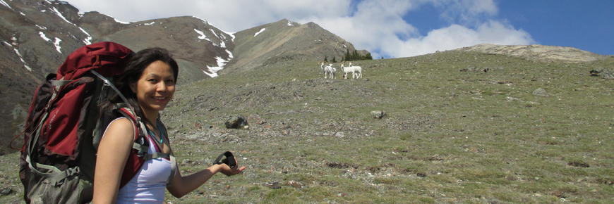
This hike usually provides excellent opportunities for wildlife viewing. The southeast face of Thechàl Dhâl (Sheep Mountain) above the Visitor Centre is a special preservation area, which provides important winter forage for the Dall sheep. Please do not hike in this area.
The Dall sheep rely on the plants of south-facing, snow-free slopes for critical nutrition. Dall sheep are high strung and may abandon parts of their range if repeatedly disturbed. Hikers and photographers are asked to be respectful of the sheep and their fragile habitat. Please:
- do not approach sheep closer than 50 metres (165 ft)
- hike in small, tight, slow-moving groups
- never approach sheep from above, as it will confuse and stress them
- put your dog on a leash, and stay far away from the sheep
- stay on established trails or routes to prevent disturbance of the soil and fragile vegetation
All overnight camping is prohibited within this area due to bear activity. For more detailed information please contact park staff at the Kluane National Park and Reserve Visitor Centre in Haines Junction or at the Thechàl Dhâl Visitor Centre.
Bear sightings are common in this area. Review recommendations for travel in the You Are In Bear Country brochure. All bear sightings should be reported to the staff at one of the Visitor Centres.
Parks Canada 24 hour emergency dispatch
1-780-852-3100
Cellular telephones do not work in most of the park. Satellite phones or satellite messaging devices are strongly recommended.
Related links
- Date modified :