
Policies and Guidelines
Parks Canada Archaeological Recording Manual: Excavations and Surveys
APPENDIX A: Parks Canada Archaeological Site Inventory Form and Form Guide
Archaeological Site Inventory Form (PDF, 255 KB)
Archaeological Site Inventory Form Guide (PDF, 590 KB)
Parks Canada
Archaeological Site Inventory Form Guide
This Guide is to be used in tandem with the “Parks Canada Archaeological Site Inventory Form”
Mandatory Data Fields (if applicable/available) are indicated with an asterisk (*)
Archaeological Services Branch, National Historic Sites Directorate, Parks Canada Agency
Contents
- How to Use this Guide
- A01 Parks Canada Site (Provenience) Number*
- A02 Site Name
- A03 Project Name
- A04 Recorder's Site Number*
- A05 Borden Number*
- A06 Permit Number*
- A07 Researcher*
- A08 Park or Site Code
- A09 Contract Number*
- Point Data (General Information)
- Guidelines for the Use of GPS
- Site Map (General Information)
- B01 UTM Coordinates*
- B02 Latitude*
- B03 Longitude*
- B04 Elevation*
- B05 Datum (Geodetic)
- B06 Determination Method (Coordinates)*
- B07 Location*
- B08 Access*
- B09 Map Reference Number *
- B10 Map Scale*
- B11 Other Map*
- B12 Minor Drainage*
- B13 Major Drainage*
- B14 Aerial Photo Reference Number*
- B15 Province/ Territory*
- B16 District/County*
- B17 Township*
- B18 Nearest Named Place
- B19 Cultural Region
- B20 Aspect
- B21 Site/ Sketch Map*
- Standard Symbols for Drawings and Maps
- C01 Environmental Setting
- C02 Soil Type
- D01 Owner*
- D02 Political Jurisdiction*
- D03 Legal Description*
- E01 Date Visited (From/To)*
- E02 Nature of Work Done (Visit Activity)*
- E03 Change Since Last Visit*
- E04 Informant Name*
- E05 Images/ Recordings*
- F01 Condition Assessment (General)*
- F02 Disturbances (Impact Agents)*
- F03 Threatened Site? *
- F04 Estimated % Disturbed/Impacted*
- G01 Site Dimensions*
- G02 Site Dimensions (Comments)
- G03 Site Description (General)*
- G04 Features*
- G05 Isolated Find*
- G06 Site Type/ Function*
- G07 Slope Angle
- H01 Site Type Class*
- H02 Cultural Period*
- H03 Scientific Dates/ Radiocarbon Data*
- H04 Culture
- H05 Cultural Strata
- I01 CRM Level*
- I02 Objects/Samples (Collected)*
- I03 Objects/Samples (Not Collected)*
- J01 Remarks
- J02 Recommendations*
- K01 Type of Documentation/ Archive*
- K02 Field Notebook Reference*
- K03 Bibliographic References
Bibliography for the Form Guide
Introduction
Parks Canada’s archaeological resources must be accurately recorded to ensure their consideration in Cultural Resource Management (CRM) decisions, and to establish a national database for research, public education, conservation, and other uses.
The Parks Canada Archaeological Site Inventory Form is used to record and report all newly discovered archaeological sites, and update the record of previously recorded or reported ones. Maintenance of the archaeological inventory is the responsibility of each of the Parks Canada Service Centres and special units located across Canada. The contents of the Parks Canada Archaeological Site Inventory Form and this Form Guide are based on an analysis of all provincial and territorial archaeological site inventory forms and guides (see bibliography), balanced with recording requirements specific to Parks Canada archaeological recording systems, as well as international archaeological data standards (see CIDOC 1998). These records, and the topographic or GIS maps on which most site locations are plotted, form the main components of Parks Canada’s inventory of archaeological sites.
Though the fields in the Archaeological Site Inventory Form reflect the Borden System requirements for all the provinces and territories, it is recommended that the appropriate institution charged with administering Borden Site Numbers be consulted to assure all current requirements are met.
One of the greatest challenges faced in such a national inventory is to accommodate the vast array of archaeological recording requirements across Canada, while incorporating, to the greatest extent possible, the reporting requirements of provincial and territorial institutions charged with administering Borden Site Number assignment. In addition, as Canada is an active participant on the CIDOC committee for the International Council of Museums (ICOM), there is a need to meet international standards for the exchange of archaeological data (see CIDOC 1998).
How to Use this Guide
Specific instructions for each data field are provided in this Guide. These correspond with the left hand column of the “Parks Canada Archaeological Site Inventory Form.” An asterisk (*) indicates mandatory fields (where applicable, or where data is available). The data fields and the form itself may be custom-tailored to meet the needs of the Service Centre responsible for recording and reporting of archaeological sites in their jurisdiction, but the fields indicated as mandatory must be filled out as accurately as possible when information is available, or if the field is applicable for the site in question.
This Guide and the associated Form are organized into generic categories that can be re-sorted and filtered, and custom-tailored as required for internal data management or recording purposes. Additional parameters for archaeological recording are outlined in the parent document “Parks Canada Archaeological Recording Manual: Excavations and Surveys” (2005). An archaeological site, regardless of its type or affiliation, should always be recorded in as much detail (and as accurately) as possible to ensure the Parks Canada inventory of archaeological sites is of maximum use for archaeological resource management, research, and conservation planning.
For assistance or clarification, please contact: Manager, Archaeological Resource Management, Archaeological Services Branch, National Historic Sites Directorate, Parks Canada Agency, 25 Eddy Street, 5th Floor (25-5-Y), Gatineau, Québec, K1A 0M5.
A. Site identification
A01 Parks Canada Site (Provenience) Number*
This is the official Parks Canada site identification (provenience) number (e.g., 130X1). It is determined by the Project Archaeologist, and must be entered if known. The parameters of “Provenience” are outlined in detail in the parent document “Parks Canada Archaeological Recording Manual: Excavations and Surveys” (2005).
Examples
5A
8B
1035G
1007T
130X1
300X100
A02 Site Name
Indicate all known sites names. Separate multiple entries by a semicolon. A site can be known by a number of names, including a local traditional (Aboriginal) name, a name attributed by a researcher, a name commonly used by people in the area, as well as the standard geographic place name noted on an NTS or other map. This field may also be used for shipwrecks.
Examples
Kittigazuit
Kittegazuit
Old Kitty
Kittygaryuit
Tsiigeh tshik
Button Point
Sannirut
A03 Project Name
Enter the name of the archaeological project. Separate multiple entries by a semicolon.
Example
Lower Fort Garry NHSC Boat Access Facilities Project
Wapusk NPC Archaeological Inventory Project
A04 Recorder's Site Number*
Indicate any temporary site number or name assigned by the researcher in the field. In the absence of an available Provenience/ Site Number, a suggested format to identify each site is to use the recorder's full name or initials, the year, and the sequential number of the site.
Examples
TR East-1
Jane Doe-2004-1
Jane Doe-2004-2
JD-2004-1
JD-2004-2
A05 Borden Number*
Leave blank for new sites. Indicate Borden (Site) Number if known (in the case of a revisit, for example). As soon as practicable, the Project Archaeologist must apply for a Borden Number from the appropriate provincial or territorial institution. Note that some archaeological sites recorded by Parks Canada may not meet provincial or territorial Borden Site criteria (e.g., due to date restrictions) and may not qualify for a Borden Number. They will remain as archaeological sites recorded under the Parks Canada provenience system (without a Borden Number). Borden Numbers are entered using the following format (additional information available online from the Canadian Museum of Civilization): first alpha character upper case, second alpha character lower case, third upper case, forth lower case, followed by a hyphen and numeric. If the Borden block is known but a sequential has not been assigned, enter a zero for sequential number. If only the upper Borden is known, enter "z" for the lowercase characters (KzNz-0). If the Borden block is unknown, enter "Y" for upper and "y" for lower (YyYy-0). Separate extra characters after sequence number with a space (KeNi-1 A).
Examples
KeNi-1
KeNi-1 A
KeNI-1 -1
KeNi-0
KzNz-0
YyYy-0
A06 Permit Number*
Indicate the number of the Parks Canada, provincial or territorial archaeological research permit held by the researcher.
Examples
NWT 96-829
NWT 2001-987
94-6ASR
NUNAVUT 2001-018A
Parks Canada Permit No. 97-00004
A07 Researcher*
List the Principal Investigators/Project Archaeologists/permit holders who have been at the site. Enter in the following format: surname, given name, initials. Names of co-investigators should be separated by a semicolon.
Example
Adams, Gary F.; Burke, Charles A.
A08 Park or Site Code
This code establishes a grouping or relationship between archaeological sites (which may be numerous) within a single geographic entity, such as a National Park of Canada or National Historic Site of Canada. If applicable, consult the authority list at the appropriate Parks Canada Service Centre for a list of valid codes for protected heritage areas administered by Parks Canada. It is used primarily for data sorting and filtering in a Parks Canada Archaeological Database. The examples below are from the Western Canada Service Centre database in Winnipeg.
Examples
H51 (York Factory NHSC)
P37 (Aulavik NPC)
A09 Contract Number*
If applicable, enter the number of the contract held by the permit holder to conduct archaeological research. Separate multiple entries by a semicolon.
Examples
1630-79-67; 1630-82-25
B. Location
Point Data (General Information)
When reporting spatial/geographic coordinate data for an archaeological site (or component of an archaeological site), include at least one of the following:
- Civilian UTM coordinates (See "UTM Coordinates" Field (Section B01));
- Geographic coordinates (See "Latitude" and "Longitude" fields (Sections B02 and B03)).
Both sets of readings are encouraged and accepted. The preferred standard is NAD 83 Civilian UTM coordinates, as this is the most widely accepted in North America at the present time. Conversion programs for NADs other than 83 are readily available on the Internet (such as the Geomatics Canada website). Decimal degrees are often requested for use in GIS databases.
Where NAD 83 Civilian UTM coordinates are not available, the following point data will be accepted:
- NAD 27 MGRS coordinates;
- NAD 83 MGRS coordinates;
- NAD 27 latitude and longitude coordinates in either degrees:minutes:seconds or decimal degrees;
- WGS 84 latitude and longitude coordinates in either degrees:minutes:seconds or decimal degrees;
- an NTS field map showing site locations.
In all cases, NTS maps showing site locations as points are required and mandatory. NTS maps at the 1:50,000 scale (or photocopy of portion thereof, to scale) are acceptable in paper or electronic format (i.e., .jpg). It is preferable that site forms be provided in Excel, Access or tab-delimited text files.
Guidelines for the Use of GPS
Detailed guidelines for the use of GPS are offered online in the document “Guidelines for Recording Archaeological Site Coordinates with Global Positioning System (GPS)”, which is available through the Prince of Wales Northern Heritage Centre (PWNHC) website (PWNHC n.d., accessed online June 2005, at http://pwnhc.learnnet.nt.ca/programs/downloads/20Jun05NWTGPSStandards.pdf). The guidelines are recommended as a standard for Parks Canada archaeological sites. In addition, the guidelines are a requirement for all Northwest Territories archaeology permits.
Based on the Guidelines noted above, the following information, at a minimum, should be recorded, preferably in the Field Notebook (parameters and/or examples are provided for each item):
- site identification number (Provenience Number highly recommended);
- the GPS model and type (e.g., Garmin 12 XL);
- the date the coordinates were taken (yyyy-mm-dd);
- units (metric highly recommended);
- the datum used (e.g., NAD 83);
- coordinate system used (UTM or Decimal Degrees highly recommended. See above.);
- geographic coordinates (for small archaeological sites less than 100 square metres, a single coordinate reading will suffice. For large sites, five readings are recommended. These should be taken at the site centre, and at the furthest extents of each of the cardinal directions. Multiple readings for large sites are of particular use in GIS applications);
- antenna height (use the top of your backpack or a tripod and enter this height. Note that low level vegetation may effect readings);
- the PDOP value for each coordinate reading (should be no greater than 6);
- 3-D Manual Mode (minimum of four satellites);
- signal strength (minimum level of 6);
- satellite elevation (minimum 15 degree angle of unobstructed visibility above the horizon is required);
- weather conditions (e.g., overcast).
Site Map (General Information)
The site map is essential for accurate plotting of the site's location and will become a critical permanent record of the site area. Two types of maps are required for the Parks Canada Archaeological Site Inventory Form: a 1:50,000 NTS map with the site accurately plotted and a detailed site map (“Site/Sketch Map”, Section B21). A 1:20,000 scale map may be included if further site location information is needed to accurately locate or plot the site. A detailed site map is: 1) essential for monitoring changes occurring at the site over time; 2) helpful in assessing the site's significance compared to other sites in the area; and 3) useful in responding accurately and quickly to various institutions without requiring another field check to determine boundaries of sites in close proximity. Please see B20 in the Form Guide for specific site mapping requirements.
B01 UTM Coordinates*
Enter the Civilian UTM Zone, the six-digit Easting and the seven-digit Northing. These coordinates should be obtained using a GPS unit. If obtained by other means (e.g., digital maps, reading from an NTS map), please note in the "Determination Method" field (Section B05), or the "Remarks" field (Section J01). Locational notations or grid overlays regarding the UTM Grid system appear on most NTS maps, and the basic method for calculating UTM coordinates is explained on the border of most gridded maps. On gridded NTS maps, the distance between each grid line is 2 cm (1000 m in the field), therefore a metric ruler can be used to calculate an Easting and Northing to the nearest hundred metres. Civilian UTMs should be used as a best practice, though the Military Grid Reference System (MGRS) may be also used if required.
Examples
UTM Zone: 10; Easting: 621700; Northing 7557350 [Civilian]
12WEF E1234 N5678 [MGRS]
B02 Latitude*
Calculate site latitude to the nearest second. Provide in degrees, minutes and seconds, or in decimal degrees format if required (e.g., for a GIS database). In the "Remarks" field (Section J01), indicate whether the coordinates were acquired using a GPS unit or calculated from an NTS map.
Examples
56d 45m 20s N
45.12345
B03 Longitude*
Calculate site longitude to the nearest second. Provide in degrees, minutes and seconds, or in decimal degrees format if required. In the " "Remarks" field, indicate whether the coordinates were acquired using a GPS unit or calculated from an NTS map.
Examples
90d 40m 30s W
124d 32m 23s W
75.12345
B04 Elevation*
Record both the elevation above sea level (ASL) and the local elevation of the site above the adjacent terrain or water. Reporting elevation in metres is preferred (to convert feet to metres multiply by 0.3048). Underwater sites should be recorded in metres above or below hydrographic datum. Enter elevation as a single number followed by BSL (Below Sea Level) or ASL. If an accurate range of elevations is available, indicate elevation "FROM" and "TO" as in the example.
Examples
30 mASL
30 mBHD
FROM: 30 (mASL) TO: 30 (mASL)
B05 Datum (Geodetic)
Indicate the geodetic datum used.
Examples
NAD 83
NAD 27
WGS 84
B06 Determination Method (Coordinates)*
Check the appropriate boxes and/or enter the method(s) and/or the instrument(s) used in calculating the coordinates of the site (including elevation), and the estimated error of each calculation. Any additional notes may be included in the "Remarks" field (section J01). Please specify to which coordinates the determination method is referring.
Examples
Derived from GPS (differential)
Wallace and Tierman surveying altimeter
Estimated from NTS map
AutoCAD Digitizing System
Hand-held GPS
B07 Location*
The purpose of the information in this entry is to make it possible for anyone to accurately plot the site on the appropriate 1:50,000 scale NTS map. Describe the site in a logical manner from general to specific, starting with a fairly general area description. Describe the site location in relation to geographic features or permanent landmarks noted on a NTS 1:50,000 map. Site location may be determined by compass triangulation (specify true, grid or magnetic north) and calculation of distances from features appearing on the NTS map (e.g., hilltop, mountain peak, river or creek mouth, esker, headland). Unmapped features, such as trees or buildings, should not be used as datum points. Distances must be measured accurately, using a tape measure, vehicle odometer, pace chart or other precise measure.
Example
Located between Campbellford and Meyersburg, west of Highway 50, on the west bank of the Trent River, 300 m west of its confluence with the Crowe River.
B08 Access*
Explain precisely how to access the site and whether the site can be reached by foot or by vehicle (motorised or other). The purpose of the information in this entry is to make it possible for anyone to readily re-locate the site in the field (or underwater) by indicating the method of travel required to access the site. Access information should complement the locational data by referring to features not necessarily found on the NTS map (e.g., local geographic features, human or animal trails) and by indicating the method of travel required. Be attentive to all details and use cardinal directions (N, S, E, W, NW, etc.) and not "left" or "right" unless accompanied by the cardinal direction.
Example
Located approximately 2 km SW of the Green Cabin, W of site 130X120, on a high bluff 300 m W of the Thomsen River. Five tundra ponds and an expansive rock outcrop are visible below site to the NE. Access by helicopter, canoe or on foot.
B09 Map Reference Number*
Indicate the reference number for the appropriate 1:50,000 (or other scale, such as 1:250,000) scale National Topographic Series (NTS) map. Non-standard maps should be recorded in the "Other Map" field.
Examples
97A (Erly Lake)
25K
25K/3W
103P/10
B10 Map Scale*
Enter the scale of the map (NTS or other) on which the site is plotted.
B11 Other Map*
Enter the name and/or number of any other (non-NTS) map(s) relevant to the site, as well as the map or issuing agency, and the scale. Please do not enter detailed site plans/sketch maps in this field (those are entered in "Sketch Map/Site Plan" field. Historic maps such as archival maps, traplines, etc. should be noted, along with scale, if available. This may include Hydrographic Chart Number(s) for underwater sites.
Example
082F Stuie, 1:250,000
B12 Minor Drainage*
The name of the body of water with which site is most closely associated. For shipwrecks: enter the name of the minor water body (harbour, body, cove, bay, etc.) within the major body containing the site of the shipwreck. Enter the smaller, immediate fresh water drainage or lake if the site is on an interior waterway.
Examples
Muskox Creek
unnamed creek
Peggy's Cove (for Coastal Shipwrecks/underwater sites)
Lake Ontario (for Interior Shipwrecks/underwater sites)
B13 Major Drainage*
The major drainage system into which the local drainage on which the site is located flows. For shipwrecks: enter the name or description of the major water body such as a strait, inlet, channel, etc. that contains the site of the shipwreck. Enter the major drainage if the site is on an interior waterway.
Examples
Thomsen River
unnamed river
Labrador Sea (for Coastal Shipwrecks/underwater sites)
Hudson Bay (for Interior Shipwrecks/underwater sites)
B14 Aerial Photo Reference Number*
Enter the aerial (air) photo reference number. Separate multiple entries by a semicolon.
Examples
A-16098-7
A-17242
Q287-45
B15 Province/ Territory*
This field indicates the province or territory in which the site is located. Enter, in abbreviated format, the name of the province or territory. Use the Canada Post Province/Territory codes. Entry must be made in upper case. Note that the code “NL” includes Labrador.
Examples
AB, BC, MB, ON, PE, QC, NS, NL, NU, NT, SK, YT
B16 District/County*
Enter the name of the district, county or shire (if applicable) in which the site is located. It may also apply to regional districts, counties or townships within the provinces.
Examples
Keewatin [District]
Simcoe [County]
B17 Township*
Enter the name of the township in which the site is located, if applicable.
Examples
Fitzroy
Nottawasaga
B18 Nearest Named Place
Enter the nearest named place(s).
Examples
Aklavik
Campbellford
Sydney
B19 Cultural Region
List the name(s) of the cultural region(s) or ethnographic area(s) in which the site is located.
Examples
Champagne-Aishihik First Nations
Kwanlin Dun First Nation
White River First Nation
B20 Aspect
Indicate the principal direction that the site faces. Use standard or cardinal indicators of direction (N, E, S, W, NNW).
B21 Site/ Sketch Map*
The British Columbia Archaeological Site Inventory Form Guide (revised 2003, available online) offers excellent minimum detailed mapping standards, which are highly recommended for Parks Canada archaeologists.
The Guide to the Saskatchewan Archaeological Resource Record (1992, available online) offers basic guidelines. Plot the boundaries of the site and the surface features or activity areas in relation to: 1) major topographic landforms and/or vegetation, such as streams, hills, meadows, etc.; 2) existing permanent landmarks such as roads, buildings, fences, geodetic markers, etc.; and 3) where appropriate, areas of erosion, proposed land use, development, etc. which could adversely impact the site. As well, indicate where authorised archaeological investigations were conducted or where objects were collected, and any areas that have been adversely impacted. Include a north arrow (north is normally toward the top of the page) along one of the map margins indicating whether this is a grid, magnetic, or true north. In addition, include feature and structure distributions, datum points, compass bearings, map scale (in metric), and map symbols in a legend. Where possible, relate the feature locations in the Site Plan/Map with features noted in the NTS Map(s) and Site Access and Location Fields.
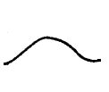
Standard Symbols for Drawings and Maps
A basic list of standard symbols for drawings and maps is offered in Table 1. These symbols are recommended as a best practice, and represent some of the more common symbols found in archaeology guides and manuals across Canada, many of which can be found in Fry (c. 1975).
| Description | Top View | Side View |
|---|---|---|
| Archaeological Site Boundary | 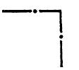 |
|
| Bridge | 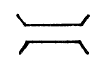 |
|
| Crest of Slope | 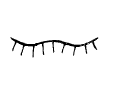 |
|
| Depression (small) | 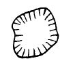 |
 |
| Mound/Hill (small) | 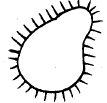 |
 |
| Stones | 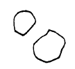 |
|
| Upright Stones | 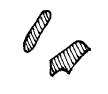 |
|
| Datum | 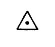 |
|
| Transit/Theodolite Station |  |
|
| Fence | 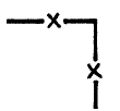 |
|
| Marsh/Swamp | 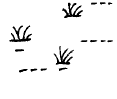 |
|
| Railway | 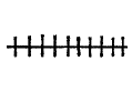 |
|
| Road | 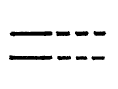 |
|
| Shovel Test | 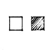 |
|
| Soil Probe Test | 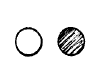 |
|
| Trail (animal or human) | 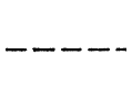 |
|
| Tree |  |
|
| Vegetation Extent | 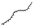 |
|
| Watercourse (River, Creek) | 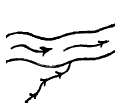 |
|
| Lake/Pond |  |
|
| Tent Ring/Stone Circle |  |
C. Environment
C01 Environmental Setting
Describe the natural setting of the site: drainage, vegetation, and landforms. If applicable, report the ecoregion in which the site is located. Useful guidelines for recording site landforms are provided in Appendix 3 of the Guide to the Saskatchewan Archaeological Resource Record (1992), available online. Habitat descriptions are also available online on the Maritime Archaeological Resource Inventory (2004) form. For vegetation, a suggested guideline is that found in the Yukon Archaeological Site Inventory Form (2004, available online): Enter the names of the dominant flora at the site. A suggested guideline is to classify the vegetation under the following headings: Trees, Shrubs, Ground Vegetation. Use either common or scientific names; list in order of most to least abundant. Indicate degree of forest cover (e.g., closed, open, parkland, secondary regrowth.) For underwater sites, include information on shorelines, exposure, wave action, visibility factors, proximity to shipping lanes, etc.
C02 Soil Type
Provide a general description of the soil matrix and soil strata, including a description of the colour, texture, depth and composition of each stratum. Use natural soil horizon terminology, with arbitrary level designations within a horizon, if required.
One of the most widely used particle size classification systems used in North America is the logarithmic “Wentworth Grade Scale”, which is shown in Table 2 below. It provides a conventional particle size classification system for soils, with a scale ranging from "boulder" (greater than 256 mm) to "clay" (less than 0.0039 mm), and intermediate ranges defining cobbles, pebbles, sand and silt. Sieves with specific mesh sizes are available so that the proportions of these various particles can be readily calculated. Common mesh and sieve sizes are described in Fladmark (1978).
| Class Terms | Millimetres (mm) | Comments |
|---|---|---|
| Boulder | Anything over 256 | |
| Cobble | 64 – 256 | |
| Pebble | 4 – 64 | |
| Granule | 2 – 4 | Granule is not a commonly encountered size or term |
| Very Coarse Sand | 1 – 2 | |
| Coarse Sand | 0.5 – 1.0 | |
| Medium Sand | 0.25 - 0.5 | |
| Fine Sand | 0.125 – 0.25 | |
| Very Fine Sand | 0.062 – 0.125 | |
| Silt | 0.0039 – 0.062 | |
| Clay | Under 0.0039 |
For comparison, note that the Province of Saskatchewan (1992) provides a simplified list of soil terms shown in Table 3 below:
| Class | Terms Millimetres (mm) |
|---|---|
| Boulder | Anything over 256 |
| Cobble | 64 – 256 |
| Gravel | 2 - 64 |
| Sand | 0.05 - 2 |
| Silt | 0.002 - 0.05 |
| Clay | 0.0002 – 0.002 |
D. Tenure
D01 Owner*
Enter the name of the legal owner of the property, as opposed to political jurisdiction, on which the site is located. See also the "Political Jurisdiction" field (D02).
Examples
Parks Canada
John Doe
Kluane First Nation
D02 Political Jurisdiction*
Indicate whether the site is under federal, provincial, municipal, or Aboriginal (First Nation/ Inuvialuit/ Inuit) political jurisdiction. If "other", please specify.
Examples
Federal
Provincial
Inuvialuit
D03 Legal Description*
Enter the coded reference to the area in which a site occurs as surveyed for Land Title Registration (Archaeology). Units and practices vary by province and territory. This field indicates the legal description of the site referenced in the Borden Number field. Legal descriptions result from surveys required for Land Title Registration purposes. For instructions on reading and reporting legal descriptions, consult the Guide to the Saskatchewan Archaeological Resource Record (1992), and the British Columbia Archaeological Site Inventory Form Guide (2003), which are both available online.
Example
1/4 NW. 1/4 of Section T-16N. R21E. W. of Meridian.
E. Visit history
E01 Date Visited (From/To)*
Enter the date(s) you (or the informant) visited or worked at the site. Indicate complete date of last visit if known (yyyy-mm-dd). For unknown date elements, enter zeros (0000-00-00) for each missing element as required. Enter any comments in the "remarks" field.
Examples
FROM: 2004-05-31 TO: 2004-06-04
FROM: 2004-05-00 TO: 2004-05-00
E02 Nature of Work Done (Visit Activity)*
Check off as many items on the Archaeological Site Inventory Form as appropriate and/or describe the range of work done at the site in the “Remarks” (J01) field.
E03 Change Since Last Visit*
For previously documented sites, have disturbances/impacts increased or decreased? Conduct a qualitative or, where possible, quantitative assessment. Use the guidelines in the "Estimated % Disturbed/Impacted" field (F04), if applicable. Describe any observed changes based on available data. Indicate complete date of last visit, if known (yyyy-mm-dd). For unknown date elements, enter zeros (0000-00-00) for each missing element as required.
E04 Informant Name*
Record the full name(s) and address(es) of any persons having special knowledge about the site (e.g., informant-reported sites).
E05 Images/ Recordings*
Indicate the type(s) of image(s) generated during the current site visit, and any digital or analog recording instruments from which records were generated. Check off as many items on the Archaeological Site Inventory Form as applicable.
F. Condition
F01 Condition Assessment (General)*
Indicate one of the three categories. These may be applied to the site as a whole, or to site components, as required (please specify). Any recommendations for the management or protection of the site may also be indicated here, or in the Recommendations (J02) field.
Good = Stable. No appreciable damage to or deterioration of known archaeological resources. No work other than regular maintenance and monitoring is required to ensure integrity of archaeological resources.
Fair = Minor damage to or deterioration of known archaeological resources, resulting in minor or potential loss of integrity. May require preservation, enhanced monitoring, mitigation, or other measures.
Poor = Major damage to or deterioration of known archaeological resources. Requires urgent preservation or mitigation (e.g., salvage) or other measures to prevent further loss of integrity or to capture information before it is lost.
Destroyed = The site is destroyed or so severely damaged that the data potential/scientific research value is deemed insufficient to warrant further archaeological monitoring or investigation.
Add any comments as required for clarification/rationale for assessment. Also note if a condition assessment has not been done.
Note: These are suggested guidelines based on the general criteria used in the State of the Parks 1997 Report (Parks Canada 1998) and Parks Canada’s May 2005 draft rating guide for Commemorative Integrity Statements. Additional discussion will be required to finalise official criteria. The "Destroyed" category was borrowed from the US National Parks Service (2003) "Guidance on Determining Archaeological Site Condition for ASMIS” (National Parks Service 2003).
F02 Disturbances (Impact Agents)*
Check off as many cultural and/or natural disturbance factors as appropriate on the Archaeological Site Inventory Form and provide a brief description, if required (or possible).
Examples
eroding (slumping)
disturbed by pothunters/looters
threatened by road construction
disturbed by ATV traffic
destroyed by unauthorised collection
F03 Threatened Site? *
Select one of three categories (Threatened, Not Threatened, or Unknown Threat). “Unknown Threat” may be used when it is not possible to determine or assess potential threats to the integrity of cultural resources.
Justification: Indicate the basis/rationale of your assessment.
Recommendations: Provide suggestions for action to alleviate impacts on cultural resources based on field inspection.
Comments: general or specific information, interpretations, etc. not previously noted.
Future Threats: Estimate future threats (disturbances/impacts) according to the following scale: High, Medium, or Low.
Rationale: Indicate the basis/rationale for your assessment, and record any potential disturbances to the site and when these disturbances are likely to occur.
F04 Estimated % Disturbed/Impacted*
This section provides more detail than the general condition of the site (see Condition Assessment field, F01). With reference to the horizontal and vertical site extent, estimate the percentage of site disturbed/impacted.
The recommended guidelines, based on the Yukon Archaeological Site Inventory Form Guide (Government of Yukon 2004) are:
- Destroyed (100%);
- Very Disturbed (50-90%);
- Disturbed (25-50%);
- Slightly Disturbed (5-25%);
- Intact (no observable disturbance).
Indicate the source of impact in the “Disturbances (Impact Agents)” field (F02). If a site has been destroyed, indicate the source of the destruction where possible.
G. Description
G01 Site Dimensions*
The following guidelines for recording site dimensions are based on those outlined in Province of British Columbia (2003).
Length: Enter the length of the site in metres followed by the cardinal direction (example NNW, ENE, N, S, E, W). Length represents the longest dimension regardless of direction. However, for a site with an irregular shape where the length varies, provide the maximum length and direction.
Width: Enter the width of the site in metres followed by the cardinal direction. Width represents the maximum direction perpendicular to length. However, for a site with an irregular shape where the width varies, provide the maximum width and direction.
Include any comments (such as previously recorded dimensions, reasons for changes, etc.) in the “Site Dimensions (Comments)” field (G02) or in the “Remarks” field (J01).
Examples
Length 200 m E/W.
Width 50 m N/S.
G02 Site Dimensions (Comments)
Discuss any previous dimensions recorded for the site and, if applicable, reasons for the amendments, as well as any other pertinent details. Indicate whether the measurements are estimates based on observation, or exact, in that the site boundaries have been determined through subsurface testing. Note whether the measurements apply to the whole site or only part of the site. Site dimensions must reflect the site boundary illustrated on the site map when using the bar scale.
Example
“In 1978, site dimensions were recorded as 100 m N/S by 25 m E/W, but in 2004 riverbank erosion had decreased site width. Site width varies from 20-25 m.”
G03 Site Description (General)*
Check off as many items as appropriate on the Archaeological Site Inventory Form to describe the site and its components.
Categories include: Surface, Subsurface, Underwater, Undetermined, Object Scatter, Single Feature, Multiple Features.
Note that “Isolated Archaeological Finds” (“Isolated Finds”) are treated in the “Isolated Find” field (G05).
G04 Features*
These are non-moveable elements of a site. Indicate the kind and number of features observed. Use a controlled vocabulary if possible (e.g., internally consistent with the appropriate Parks Canada Service Centre, or provincial/territorial heritage institutions, or the Canadian Heritage Information Network (CHIN)). Separate multiple entries by a semicolon.
Examples
cache (descriptor)
grave
hearth
inuksuk
medicine wheel
midden (descriptor)
rock alignment (descriptor - e.g., drive lane, caribou)
structure (descriptor - e.g., cellar, dam, furnace, rampart, well )
tent ring
hunting blind
G05 Isolated Find*
Check "Yes" if this is an Isolated Archaeological Find (“Isolated Find”), and provide a rationale if it is to be reported as an "Archaeological Site". The Parks Canada definition of "Isolated Archaeological Find" (Isolated Find) is: "A single archaeological object that is or was located in situ on, below or above the ground, or lands under water, such as a single projectile point, or fragments from a single ceramic vessel. Other criteria may be applied to the definition at the discretion of the archaeologist, provided a rationale is included." All Isolated Finds must be recorded, and must be assigned a Provenience Number. Isolated Finds may be reported as an archaeological site at the discretion of the Project Archaeologist, provided a rationale is included.
G06 Site Type/ Function*
Enter the site type as determined by the researcher. Use the examples provided here as a general guideline, or use the site type appropriate to your jurisdiction. Use of the criteria or authority lists, if available, adopted by the institution assigning Borden Numbers for a given province or territory, is recommended. For the site type "campsite", it is recommended to enter "campsite (purpose, type,
season)". "Season" is listed in the following order: spring, summer, fall, winter. Indicate tentative assignations with a space and a "?" after the term. An excellent example of site classes, types, and functions can be found in Appendix 3 of the British Columbia Archaeological Site Inventory Form Guide (2003, available online).
Examples
administrative centre
battlefield
campsite (hunting, caribou, spring)
campsite ?
ceremonial/religious (cemetery, grave, mortuary pole, spirit house, platform, sweat lodge)
commercial
cultural depression (menstrual lodge, sweat lodge, plank house, cache pit)
defensive
earthwork (trench embankment, mound, fortification)
food harvesting (killsite, corral, drive lane, trap, deadfall)
fort
habitation (platform, cave, rock shelter, refuge)
irrigation farming
landmark (NHSC plaque)
material harvesting (oil refinery, mining)
mission
port
subsistence (fishing, hunting, fowl)
trading post
transportation (trail)
undetermined
wharf
workshop (lithic)
G07 Slope Angle
Estimate the angle (degree) or percent of the slope on which the site or resource rests. A clinometer, found on most compasses (e.g., Brunton), can be used to estimate the angle.
H. Culture
H01 Site Type Class*
This field indicates a first level classification of the site type based on its broadly defined associated period of occupation and/or function. Use the site type class appropriate to your jurisdiction. Use of the criteria or authority lists, if available, adopted by the institution assigning Borden Numbers for a given province or territory, is recommended. As a general guideline, it is recommended to use the Canadian Museum of Civilization criteria: choose one or combination of: pre-contact; indigenous historic; historic; contemporary; natural, undetermined. Tentative assignations are identified by the entry of a space and a “?” after the term. Separate multiple entries by a semicolon.
Examples
Pre-contact
Pre-contact ?
historic
indigenous historic
contemporary
natural
undetermined
H02 Cultural Period*
Indicate the period of occupation of the site as determined by non-laboratory means, by the Project Archaeologist/Principal Investigator. Indicate relative dates, if known.
Examples
pre-White River Ash
15th century ?
17th-18th century
4000-2000 B.P.
H03 Scientific Dates/ Radiocarbon Data*
Indicate absolute dates acquired from the site or site components, if available. Enter each date, the error margin and the lab number. If a technique other than radiocarbon dates is used, enter the technique in parenthesis after the lab number. Specify the material, context and associations of the date, and the investigator acceptance/rejection of the date with rationale.
Examples
1690 +/- 50 (Beta-99129)
1380 +/- 105 (S-466) (NMC-302)
1930 +/- 200 (RIDDL-325)
H04 Culture
The Canadian Museum of Civilization's approach is suggested as a guideline. Enter the archaeological culture(s) thought to be represented at the site. Use of the criteria (or authority lists), if available, adopted by the institution assigning Borden Numbers for a given province or territory, is recommended. Tentative assignations are identified by the entry of a space and a "?" after the term. Modifiers may be appended in parenthesis after the term. Separate multiple entries by a semicolon.
Examples
Dene
Pre-Dorset ?
Eurocanadian
French-Canadian
Métis
Innu
H05 Cultural Strata
Provide a concise description of the general classes of cultural materials found in each soil horizon. Include a description of the colour, texture and composition of the soil matrix and a short summary of shovel tests, soil probes or test units. For the Yukon, if White River ash is present in the site deposits, indicate depth of cultural materials below ash.
Examples
Fine grain yellowish brown sandy loam (Munsell: 10 YR 5/4, Particle Size 0.25-0.5 mm) charcoal
I. Management
I01 CRM Level*
List the site's overall Cultural Resource Management (CRM) level, or the CRM level of site elements if required (please specify), based on Parks Canada's CRM Policy criteria (Parks Canada 1994:106-8). Also indicate rationale for your evaluation.
I02 Objects/Samples (Collected)*
Indicate the general range of archaeological objects/samples that were collected; check off as many as appropriate on the Archaeological Site Inventory Form. Also note the repository where they will be housed (see example). Add any comments in the "Remarks" field (J01).
Examples
PARKS CANADA (WCSC Calgary)
PWNHC
CMC
I03 Objects/Samples (Not Collected)*
If present, indicate the general range of archaeological objects or samples observed at the site but not collected (check as many as appropriate). Also indicate whether archaeological objects are present (observed) or absent.
J. Comments
J01 Remarks
Enter general and descriptive information on the site features, research activities, factors that might have affected GPS use and/or coordinate readings (i.e., topography, readings acquired while hovering in helicopter, operational error, etc.). Enter any recommendations in the "Recommendations" field (J02).
Examples
“Unable to plot accurately due to dense forest cover.”
“Original GPS coordinates submitted as (NAD not specified): 643068N 1381457W.”
“Sites 130X213 (PiPw-20) and 130X214 (PiPw-21) reported by Webster in 1995 might, in fact, be
an extension of the same site.”
“The main area of the site comprises 3 circular tent rings (Features 1 to 3). Feature 1 has a clearly
defined central line of small flat rocks. Surface lithics and bone (all apparently culturally modified)
were observed at Features 1 and 2."
J02 Recommendations*
Enter any recommendations pertaining to site or site components, including monitoring, surveillance, and additional research.
Example
“Annual monitoring is recommended as the site is highly visible and is located in a high visitor traffic area during the warmest months of the year."
K. Reference
K01 Type of Documentation/ Archive*
Check off as many items as applicable on the Archaeological Site Inventory Form. This field indicates the type of documentation or archive associated with the site (e.g., still or moving images, field notes).
K02 Field Notebook Reference*
Indicate the page(s) of the Field Notebook where the site is referenced. 2004-7P-1 to 4
K03 Bibliographic References
Enter the unpublished and published references specifically related to the site. The Canadian Museum of Civilization’s format, noted below, is recommended.
For unpublished references:
MS000123
ASC ARCHIVES Ms. 2980
For published references:
1955 Collins, H. B. "Dorset Dwellings" SCIENCE Volume 122, No. 3175, Nov. 4
Bibliography for the Form Guide
Canadian Museum of Civilization (2004) Canadian Museum of Civilization Archaeological Sites Database (Available online at: http://collections.civilisations.ca/sites/sitwe01e.html Accessed online June, 2005).
CIDOC (1998) International Core Data Standard for Archaeological and Architectural Heritage. CIDOC (Comité international pour la documentation, conseil international des musées/International documentation committee, international council of museums) Paris.
Fladmark, Knut R. (1978) A Guide to Basic Archaeological Field Procedures. Dept. of Archaeology, Simon Fraser University, Vancouver.
Fry, Bruce (c. 1975) “Standardized Symbols: Archaeological Drawings.” Extant Recording Section, Indian and Northern Affairs, Ottawa. Manuscript on file, Archaeological Services Branch, Parks Canada, Ottawa, Gatineau.
Government of Yukon (2004) Yukon Archaeological Site Form. Department of Tourism and Culture, Cultural Services, Heritage Resources Unit, Whitehorse. (Available online at: http://www.yukonheritage.com/application_forms-archpermit.htm Accessed online June 2005).
Government of Yukon (2004) Yukon Archaeological Site Form Guide. Department of Tourism and Culture, Cultural Services, Yukon Archaeology Program, Heritage Resources Unit, Whitehorse. (Available online at: http://www.yukonheritage.com/application_forms-archpermit.htm Accessed online June 2005).
National Parks Service (2003) “Guidance on Determining Archaeological Site Condition for ASMIS.” 18 Dec 2003 memorandum on file from Terry Childs to Jim Molnar, Archaeological Services Branch, Parks Canada, Ottawa-Gatineau.
Parks Canada (1994) Parks Canada Guiding Principles and Operational Policies. Minister of Supply and Services Canada, Ottawa.
Parks Canada (1998) State of the Parks 1997 Report. Parks Canada, Ottawa.
Parks Canada (2001) “Parks Canada Metadata Standards.” Draft Version 1.10, Unpublished report by the Data Administration Group and the Geomatics Metadata Working Group, Parks Canada Agency, Ottawa-Gatineau.
Parks Canada (2003) “Report to Parks Canada Agency: Digital Multimedia Asset Management Functional Requirements.” Version 2.0, 31 March 2003, Unpublished report by Sierra Systems for Parks Canada, Ottawa-Gatineau.
Parks Canada (2003) “Report to Parks Canada: Digital Multimedia Asset Management (DMAM)
System Policy Requirements.” Version 2.0, 31 March 2003. Unpublished report by Sierra Systems for Parks Canada, Ottawa-Gatineau.
Prince of Wales Northern Heritage Centre [PWNHC] (n.d.) Guidelines for Recording Archaeological Site Coordinates with the Global Positioning System (GPS) Northwest Territories Education, Culture and Employment, Prince of Wales Northern Heritage Centre, Yellowknife. (PDF version available online at: http://pwnhc.learnnet.nt.ca/programs/
downloads/20Jun05NWTGPSStandards.pdf . Accessed online September 2005).
Province of British Columbia (2000) British Columbia Archaeological Inventory Guidelines. Version 1, Ministry of Small Business, Tourism and Culture, Archaeology Branch, British Columbia. (Available online at: http://iehost.net/pdf/inventoryguidelines.pdf Accessed online April 2007).
Province of British Columbia (2004) British Columbia Archaeological Site Inventory Form. Ministry
of Sustainable Resource Management, Archaeological Registry Section.
(Word and PDF versions are available online at: http://www.tsa.gov.bc.ca/archaeology/publications.html and
specifically at: http://www.tsa.gov.bc.ca/archaeology/pubs/formguide/February_06_Guide.pdf Accessed online April 2007).
Province of British Columbia (2003) British Columbia Archaeological Site Inventory Form Guide.
Ministry of Sustainable Resource Management, Archaeological Registry Section
(Available online at: http://www.tsa.gov.bc.ca/archaeology/pubs/formguide/February_06_Guide.pdf. Accessed online May
2005)
Province of Saskatchewan (2004) Saskatchewan Archaeological Resource Record. Saskatchewan Culture, Youth and Recreation, Heritage Resources Unit, Archaeological Resource Management, Regina (Available online at http://www.cyr.gov.sk.ca/assets/pdf/SARR92 - Guide to the SARR 1992 version updated Nov18-04.pdf. Accessed online June, 2005).
Province of Saskatchewan (1992) Guide to the Saskatchewan Archaeological Resource Record. June 1992. Saskatchewan Culture, Youth and Recreation, Heritage Resources Unit, Archaeological Resource Management, Regina. (Available online at: http://www.cyr.gov.sk.ca/assets/pdf/SARR92 - Guide to the SARR 1992 version updated Nov18-04.pdf. Updated.November 2002. Accessed online June 2005).
Nova Scotia Museum (2004) Maritime Archaeological Resource Inventory. Nova Scotia Museum, Heritage Resource Services, Halifax. (Available online at http://www.gnb.ca/0131/Archaeology/pdf/mari.pdf Includes Nova Scotia, New Brunswick, and Prince Edward Island. Accessed online June 2005).
Swannack, Jervis (1973) “Archaeological Excavation Manual.” National Historic Sites Service, National and Historic Parks Branch, Department of Indian Affairs and Northern Development, Ottawa.
Stryd, Arnould H. (2001) Culturally Modified Trees of British Columbia: A Handbook for the Identification of Culturally Modified Trees. Version 2.0. Archaeology Branch, B.C. Ministry of Small Business, Tourism and Culture. (Available online at http://www.for.gov.bc.ca/hfd/pubs/docs/mr/mr091.htm. Accessed online June 2005).
Previous Page | Table of Contents | Next Page | Printable Version (PDF, 1,237 KB)
Related links
- Parks Canada Archaeological Recording Manual: Excavations...
- Preface
- Introduction
- Work Instrument or requirement
- Provenience system
- Organizing field projects
- Field notes
- Images
- Drawings, maps and other media
- Traceability
- Bibliography
- Recommended reading
- Abbreviations
- Printable version (PDF, 1.24 MB)
- Date modified :