
Mapping ecological and cultural values in the Kespukwitk conservation corridor
Parks Canada's report on conservation from 2018 to 2023
- Conservation priority
- Landscape-scale conservation
- Location
- Kejimkujik National Park and National Historic Site, Nova Scotia
By building trust and strengthening relationships, Mi’kmaq of Nova Scotia, Parks Canada and over 15 conservation partners collaborated to develop an interactive map highlighting areas of ecological and cultural importance for conservation in the Kespukwitk Conservation Corridor.
The map is informing species at risk recovery action and land stewardship priorities in the Kespukwitk Conservation Corridor area. It is supporting decision making guided by Mi’kmaq leadership for landscape-scale conservation across the region.
Project highlights
- 15 partnering organizations participated in several in-person and online Kespukwitk Conservation Corridor workshops
- Over 70 data layers of ecological and cultural significance were integrated in one online map
- 884 historical aerial photos, covering an area of 1700 km2 of the Mersey River watershed were georeferenced and combined
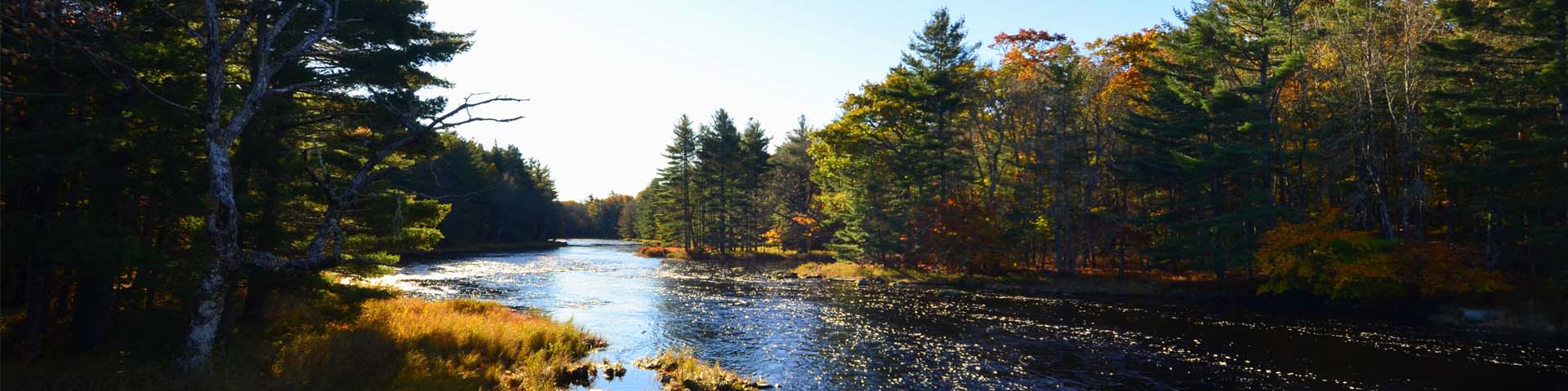
The Mersey River is a central feature of the Kespukwitk Conservation Corridor as it provides connectivity for both culture and nature from the interior of Nova Scotia to the coast. Photo: Éric Le Bel/Parks Canada
Context

The Kespukwitk Conservation Corridor is a significant region in southern Nova Scotia, marked by its rich biodiversity and cultural importance to the Mi’kmaw Nation. The area is located in Mi’kma’ki, the ancestral and unceded territory of the Mi’kmaq, where they have lived, travelled, and hunted for thousands of years, and continue to do so today.
The corridor runs through the Kespukwitk Priority Place, one of 11 priority places across Canada. The priority place program brings together multiple conservation practitioners using a holistic ecosystem approach to recovering species at risk. Kespukwitk was selected as a priority place due to significant biodiversity and the high amount of conservation work already taking place.
The Kespukwitk Conservation Corridor links natural areas in a way that allows the natural movement of species and the flow of natural processes across the region. It stretches from the Bay of Fundy to the Atlantic Coast, encompassing Kejimkujik National Park and National Historic Site, and Kejimkujik National Park Seaside.
Working together

In 2019, the Confederacy of Mainland Mi'kmaq, Wasoqopa’q First Nation, L’s+tkuk First Nation, Kwilmu’kw Maw-klusuaqn and Parks Canada, with the Nova Scotia provincial government, other federal government departments and non-governmental organizations, began collaborating to explore the ecological and cultural connectivity throughout the Kespukwitk Conservation Corridor.
Outcomes
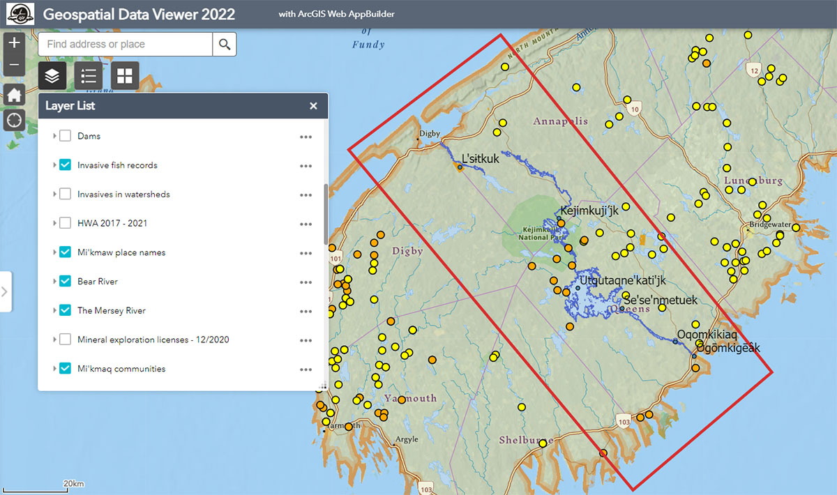
Image description
A detailed map of the southern region of Nova Scotia, features rivers, lakes, roads, and other geographic features. The Kespukwitk Conservation Corridor Study Area is shown by a red rectangle overlayed over the map. It extends from the Bay of Fundy, in the Annapolis Valley area surrounding Digby, NS, across Nova Scotia tthe Atlantic Ocean coast between Shelburne, NS, and Bridgewater, NS. Kejimkujik National Park is indicated in the center of the red rectangle through darker green shading. It is almost equidistance from the Bay of Fundy and the Atlantic Ocean. On the left side of the map, is a scrolling list of available data layers. These layers can be selected treveal different types of information on the map. The data types currently visible in the list are dams, invasive fish records, invasives in watersheds, HWA 2017-2021, Mi’kmaw places names, Bear River, the Mersey River, mineral exploration licenses – 12/2020, and Mi’kmaq communities. Above this list is a search bar to find specific addresses or places on the map.
The following data layers have been selected on the list and the related data is shown on the map:
- Invasive fish records: Over 100 points spread over the map on a multitude of waterways. The points are most densely shown in the western portion of the map and are less dense within the red rectangle indicating the Kespukwitk Conservation Corridor Study Area.
-
Mi'kmaq place names: Mi’kmaq place names are superimposed on the map within the red rectangle indicating the Kespukwitk Conservation Corridor Study Area. From north tsouth across the map, these include:
- L’sitkuk, located in the Annapolis Valley between the towns of Annapolis Royal and Digby
- Kejimkuji’jk in the center of Kejimkujik National Park
- Utqutaqne’kati’jk, indicating Lake Rossignol
- Se’se’nmetuek, located at the southern end of Lake Rossignol
- Oqomkikiaq near the southern end of the Mersey River
- Ōgōmkigēâk, located at Liverpool
- Bear River: The river is outlined in dark blue. It extends a short distance northward within the red rectangle area indicating the Kespukwitk Conservation Corridor Study Area and ends in the Annapolis Basin.
- The Mersey River: The river is outlined in dark blue. It extends almost all the way across the area enclosed by red rectangle indicating the Kespukwitk Conservation Corridor Study Area. It begins at the north of the map near Bear River and extends south through Kejimkujik National Park, Kejimkujik Lake, Lake Rossignol, and ends in the Atlantic Ocean at the town of Liverpool, NS.
-
Mi’kmaq communities: The areas of Mi’kmaq communities are superimposed on the map as orange boundary shapes, within the red rectangle indicating the Kespukwitk Conservation Corridor Study Area. From north tsouth across the map, these include:
- A small area at the mid-point of Bear River, along the western bank, known as L’sitkuk First Nation
- A small area extending between the north end of Ponhook Lake and Molega Lake, known as Wildcat Community, part of the Wasoqopa’q First Nation
This interdisciplinary group of partners compiled large volumes of ecological and cultural data, historic aerial photos, maps and stories. The work integrated diverse resources on archaeology, culture, ecological values and species, and wove Mi’kmaq Traditional Knowledge Systems and Western science into an interactive, multi-layered map. The comprehensive map is being used in the collaborative planning and implementation of recovery and conservation measures for species at risk and species of cultural importance throughout the Kespukwitk Priority Place.

“The knowledge of our Ancestors has been passed down through generations through stories. These stories are the lived experiences of our Ancestors. We keep our Ancestors, grandparents and parents’ knowledge alive through storytelling. From this, we are able to walk where our Ancestors walked, paddle the rivers and lakes our Ancestors paddled. Through our stories and with the revitalization of our Mi’kmaw language, these stories will live on and this knowledge will be transferred to future generations. This is one of the greatest gifts we can give our children.”—Keptin Jeffrey JC Purdy, Sante’ Mawio’mi Mi’kmaq Grand Council, Wasoqopa’q First Nation
Learn more
Related links
- Date modified :