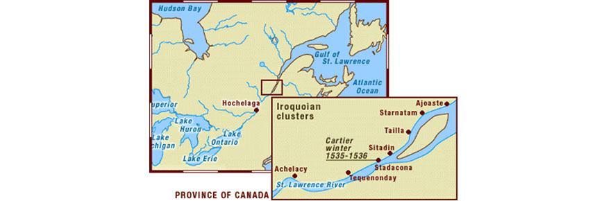
The geography of the province of Canada
Cartier-Brébeuf National Historic Site
It was in this province that Cartier spent two winters. The narratives he left of his voyages nevertheless contain a number of inaccuracies. For example, researchers have frequently attempted to locate the precise borders of the province of Canada, but their findings have given rise to a variety of interpretations. Cartier himself makes no mention of a western limit and is far from being clear when he does refer to an eastern limit. As a rule, researchers have nevertheless located the western border in the vicinity of the current town of Portneuf, whereas the eastern border coincided with either the Montmagny archipelago (about 32 km down river from Québec) or Île aux Coudres.
Cartier counted seven clusters of population in the province of Canada, all located on the north shore of the St. Lawrence. Going from east to west, they were: Ajoaste, Starnatam, Tailla, Sitadin, Stadacona, Tequenonday and Hochelay (or Achelacy). It should be pointed out that Cartier did not speak of villages but of peuples et demourances (populations and habitations) instead, which leaves much room for interpretation of what these place names corresponded to. In some cases, they may have referred to fishing camps along the shore of the St. Lawrence. The location of these sites is open to conjecture as well, except in the case of Achelacy, which lay at the foot of the Richelieu rapids, and Stadacona, which was sited somewhere along the northern face of the promontory of present-day Québec, facing the right bank of the St. Charles River. Nevertheless, archaeological exploration has not yet pinpointed where either of these settlements were located.
- Date modified :