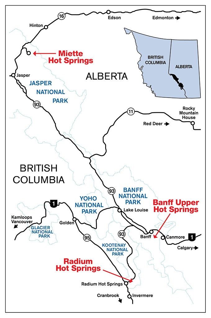
How to Get There
61 km east of Jasper townsite
51 km west of Hinton
GPS: 53.12984, -117.772356 decimal degrees Or N 53° 7' 47.424", W -117° 46' 20.5
From Jasper, proceed east on highway 16 for 44 km to the Pocahontas Bungalows and the Miette Road junction. From Hinton, proceed west on highway 16 for 34 km to Pocahontas Bungalows and the Miette Road junction. From there, proceed south on the Miette Road. Miette Hot Springs are at the end of Miette Road, 17 km ahead.

Map - Text Version
This map shows the various facilities of the Canadian Rockies Hot Springs Enterprise Unit. Featured on the map are the precise locations of Miette Hot Springs, Radium Hot Springs, and Banff Upper Hot Springs. The map shows portions of western Alberta and eastern British Columbia, and locations of Jasper National Park, Banff National Park, Yoho National Park, Glacier National Park, and Kootenay National Park respectively.
The map features different highways including the Trans-Canada Highway, Highway 93, Highway 95, Highway 16, and Highway 11. The map also has the locations of different towns in the area, including Banff, Canmore, Golden, Jasper, Hinton, Invermere, and more.
Banff Upper Hot Springs is located at the top of Mountain Avenue, 4 km south of the Banff town center. Follow Banff Avenue over the Bow River and turn left (east) at the last set of traffic lights. Follow the signs for 3.6km to the hot springs parking lot. Banff Upper Hot Springs is 128 km west of Calgary and 25km east of Castle Mountain Junction (Trans-Canada Highway).
Radium Hot Springs is located off Highway 93. If arriving from the west, the hot springs are 3km east from the junction of Highways 93 & 95, and the town of Radium Hot Springs. If arriving from the east (Calgary or Banff), take the Trans-Canada highway to Castle Junction in Banff National Park. At Castle Junction, take highway 93 south to Kootenay National Park and proceed until you reach the hot springs. Radium Hot Springs 260km west of Calgary and 3km northeast of the town of Radium Hot Springs.
Miette Hot Springs is located at the end of the Miette Road. The Miette Road junction is off Highway 16 and next to the Miette Mountain Cabins. Once at the junction, proceed south on the Miette Road for another 17km. Miette Hot Springs is 61km east of the Jasper town site and 51km west of Hinton.
- Date modified :