Welcome to ʔapsčiik t̓ašii (pronounced ups-cheek ta-shee)
Pacific Rim National Park Reserve
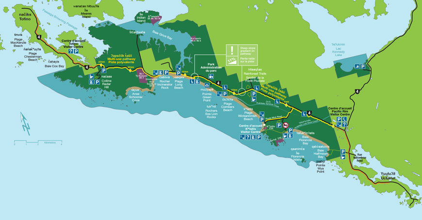
ʔapsčiik t̓ašii (pronounced ups-cheek ta-shee) is the new multi-use pathway, located in the ḥaḥuułi — the traditional territories and homelands — of the Tla-o-qui-aht First Nation and Yuułuʔiłʔatḥ. It extends approximately 25 km from the southern to the northern boundary of the Long Beach Unit of Pacific Rim National Park Reserve. The pathway is paved along its entirety and provides access to numerous points of interest found in the national park reserve. Although the pathway is fairly flat, there are a few short, steep hills and curves along the way.
ʔapsčiik t̓ašii is best enjoyed from mid-April to mid-October.
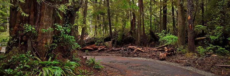
A Winter Conditions Warning is in effect on the ʔapsčiik t̓ašii during the winter as the area experiences regular rain, wind, and some snow events. As the pathway is not maintained during the winter, debris, including fallen trees, leaves and sometimes snow and ice may be present, and travel is not recommended.
How to pronounce ʔapsčiik t̓ašii
Recording of Kaamatḥ, Levi Martin, Tla-o-qui-aht First Nation Elder
ʔapsčiik t̓ašii means going the right way on the path and ʔapsčiik t̓ašii has a second meaning & make sure you speak the truth.

Please respect the following advisories:
- Stay on the path: Respect the privacy of the communities of Esowista and Ty-Histanis by not entering or cutting through them without permission. By staying on the path, you can also protect sensitive ecological areas.
- Road safety: Use extreme caution at the uncontrolled crossings near Radar Hill and on Wick Road.
Trail Etiquette
- Share the pathway:
- Always keep to the right.
- Announce “on your left” and pass with care.
- Travel at a reasonable and controlled speed.
- Move off the paved pathway to take a break.
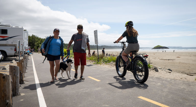
- Cyclists must yield to all other users.
- Keep pets on a leash, under control and on the designated path at all times. Please keep pets on the same side of the pathway as you.
- Pick up after your pet.
- Do not litter or leave anything behind. Pack it in, pack it out.
- Harvesting of any object, artifact or natural resource is prohibited.

Your Safety
Before you set out:
Parks Canada makes every effort to ensure visitor safety, however all outdoor activities involve some degree of risk. Please remember that your safety is your personal responsibility. Be well prepared for your chosen activity and wear appropriate safety equipment related to your activity.
- Stay alert and be aware of your surroundings.
- Cell phone coverage is not always reliable. Let someone know your plans before heading out.
- Weather may change at any time. Check the forecast and bring appropriate clothing/gear.
- Wind events can leave large debris on the pathway. Use caution and avoid travelling through the forest during a wind event.
- The pathway surface may be slippery in icy or wet conditions.
- Bridges and boardwalks are often slippery, but especially in wet or icy conditions.
- In winter, daylight hours are limited, so plan enough time to return safely.
Protecting Wildlife
When you visit Pacific Rim National Park Reserve, you are visiting an area that is home to a diverse array of wildlife. Your behaviour can have an impact on the safety of wildlife, yourself, and other visitors.
Wildlife respect and safety
- Always stay on designated pathways.
- Keep pets on a leash and under control at all times.
- Keep a safe distance from wildlife.
- Freshwater fishing is prohibited.
- ‘Do not feed wildlife. Human food kills animals.
In case of emergency, contact: or
Report all wolf, cougar, and bear sightings to Parks Canada at
In the case of immediate conflict, if you encounter or are approached by wildlife:
- Act big
- Make noise
- Don’t run
Video Gallery
Building ʔapsčiik t̓ašii - Part 1: Creating a Pathway Together
Transcript
[Music]
<
in our language it has two meanings
ʔapsčiik is going the right way on the path.
You know, also, ʔapsčiik means to
make sure you speak the truth.
That was a very important teaching for
our people to speak the truth.
<
multi-use
path that is 25 kilometres within the
homelands of the
Tla-o-qui-aht First Nation, the Yuułuʔiłʔatḥ First
Nation
and within Long Beach Unit of Pacific
Rim National Park Reserve.
So it's 25 kilometres connecting
every community within the region from
Tofino to Tla-o-qui-aht to
Yuułuʔiłʔatḥ lands, into the Ucluelet
district.
So, it's providing that route and that
artery
for this region that allows people
to experience what this area has from
land
to sea. It's a wonderful path that's
going to connect
everybody.
[Music]
<
not an easy thing.
It's not like building your standard
highway or building your standard trail—
there's so many things to take in
consideration.
We're working with First Nation
partners, we're looking at environmental
consequences,
we're looking at invasive species and
amphibians and archaeological sites. So
when you're looking at
moving the trail slightly two meters
away from the highway or closer to the
highway
you really have to take into account all
these different elements and think ahead
about those things and plan with them
and talk to your experts.
<
visitors to the originators of this
area who still reside today and have
been working with us from
day one on the ʔapsčiik t̓ašii to really
help us understand
the appropriate route to take that not
only is environmentally sensitive
and culturally protecting the area but
also that
really connects the visitor to what they
experienced in their homelands and
that's what the ʔapsčiik t̓ašii was meant
to do,
was to help visitors really see and
understand
the First Nation context that is within
this area.
<
like
roots that we can munch on and the beach
is
very generous with seafood. You know, you
could survive out there all day without
bringing lunch from home and we want it
to stay that way.
We want everything in that area to stay
as natural as possible.
<
in 25 years is going to change the
landscape to this area
but is also going to really bring
Pacific Rim National Park Reserve, First
Nations,
and districts together to really
look at how we welcome our visitors to
this region
and how we protect it because that's
what it has done—
it has allowed us to really
embrace the one team, the one voice and
the one vision
with different parties, not just Parks
Canada.
<
something that many people are going to
enjoy for years to come...be able to use
to connect destinations, to connect
communities.
<
benefits
the economic opportunities for
Indigenous partners,
but it's also just the benefit of
something new to the area.
<
National Park coming together and
working together and acknowledging the
land
I felt like, "ʔapsčiik t̓ašii"—we are going
the right way, like you know. We're coming
together and
walking together and turning together
in a good way.
Building ʔapsčiik t̓ašii - Part 2: Planning the Pathway With Care
Transcript
00:06 <> Our ancestors had an understanding about 00:11 the cycle of life. We come from Mother Earth and then after life, then we go back into 00:19 Mother Earth. If we fall a tree 00:22 we put a part of the tree—the spirit of the tree— 00:27 back into the ground so that he will 00:29 always come back and always be plentiful. 00:46 <> Building in a national park reserve has taken 00:51 more studies and work and investigation and care than any projects I've worked 00:57 on in my lifetime. 01:12 <> We really wanted to stay within principles that the First Nations 01:17 and the Park Reserve had established of 01:20 "hishukish ts'awalk", 01:21 everything is one. "uu-a-thluk", taking care of, and "iisaak" respect. 01:27 <> We teach them from very young that we are all one with the land the 01:33 water 01:33 the air and everything in it. [Music] 01:41 <> The design wasn't chosen until we came 01:45 out to the park and did specific studies. So, we worked with the First Nations to 01:48 do traditional use studies, 01:50 we worked with our environmental experts to do a detailed impact assessment, 01:54 and we also worked with archaeologists and once all that information was put 01:58 together, we were then able to 02:00 flag the best route which really minimized environmental impacts and 02:03 archaeological impacts and would provide the 02:05 best visitor experience. 02:08 <> In taking the trail through this area it 02:11 was important to 02:13 make sure that it's done responsibly and that we're still maintaining that refuge 02:16 for animals 02:17 while also presenting these really unique habitats to park 02:22 users, so we can go buy them without going into them 02:25 and harming these areas and just show people how beautiful these habitats are. 02:30 <> For archaeological preservation, we follow the Parks Canada 02:34 Agency guidelines. The general protocol 02:37 is to always avoid impacts and avoid disturbance to site where possible. 02:40 Where not, we do data recovery to find as much information as we can 02:45 and try and find a design that's going to have the least impact and disturbance 02:49 to archaeological materials. 03:04 <> We are doing things now the way things should have been done 03:09 in the beginning and the people that are going to be coming in 03:13 and walking the pathway, I feel like it'll be 03:16 important for us to share these teachings about honour and respect 03:21 and humility.Building ʔapsčiik t̓ašii - Part 3: Human-Wildlife Coexistence
Transcript
Transcript 0:01 <> One of the things, like, when I was taught 0:07 as a child with my father...there's a place in 0:11 Kennedy Lake… …a river there called Tla-ook. 0:14 He said we're going into a place where 0:16 there's going to be a lot of fish and where there's a lot of fish 0:21 the bears will be there and the wolves will be there. 0:24 Before you go in, you talk to the bears, you talk to the wolves, you ask them to 0:31 allow you to do the work that you need to do. 0:34 And you will not do them any harm or their territory. 0:48 [Music] 0:58 <> It was really the highest standard of 1:09 environmental oversight on this project and for good 1:14 reason, 1:15 you know, it's a really beautiful coastline and this 1:18 this refuge for all these animals, so it was really carefully considered where 1:23 the trail 1:29 went through. 1:36 <> We have six species of amphibians that 1:42 are living 1:44 in the park along the ʔapsčiik t̓ašii. 1:46 Because we couldn't avoid 1:47 them—they would be moving in and 1:49 breeding in all these little pools along the trail— 1:52 we had to do some salvage. 1:53 <> It's the last chance to kind of get these animals out 1:56 and we're protecting them 1:58 and keeping them in the part of the stream that won't be harmed during 2:01 construction so that by the time they move through, there's 2:04 nothing in there and it gets restored back to normal and then 2:08 the animals get released back into the 2:10 site [Music] 2:14 <> The next thing we did was to install 2:20 culverts which will try to allow the amphibians to move 2:23 underneath and this provides moist 2:26 habitat for them during dry periods of 2:28 the year. 2:29 So, for instance, in the summertime 2:31 when they wouldn't want to cross a dry trail, but they will go through an 2:36 underpass that's nice and moist and has lots of 2:39 forest cover in there. 2:41 This will now allow them to cross safely from one side of 2:44 the highway to the other and under the trail and into the forest. 2:52 <> The park, we're finding, is even more 2:57 diverse than we realized. 2:59 We're seeing crayfish and cutthroat 3:01 trout, coho alongside northwestern salamander larvae, 3:05 red-legged frog, dragonfly larvae and all kinds of species that are living 3:10 all together in these tiny little streams. 3:13 So that's been a treat to get to see that and record 3:16 that and that information is going to go towards the park in future. 3:18 [Music]Building ʔapsčiik t̓ašii - Part 4: Taking an Adaptive Approach
Transcript
<Related links
- 150 adventures for your bucket list
- Long Beach Unit
- West Coast Trail Unit
- Birding
- Boating
- Camping
- Cycling, mountain biking, and e-biking
- First Nations cultural experiences
- Fishing
- Geocaching
- Hiking
- Hiking: West Coast Trail
- Kapyong Memorial at Radar Hill
- Kwisitis Visitor Centre
- Red Chairs
- School and group programs
- Storm watching
- Surfing
- Volunteer opportunities
- Licensed operators
- Date modified :