Alcids
Mingan Archipelago National Park Reserve
Bird’s eye view of feeding areas
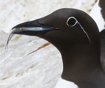
Certain avian species in the Mingan Archipelago National Park Reserve, feeding in waters where there is significant marine traffic, are particularly vulnerable to oil spills.
In 2019, the Canadian Wildlife Service and students from McGill University took a closer look at these more at-risk species. One of the objectives of their project was to map the feeding areas of the Razorbill (Alca torda), Atlantic Puffin (Fratercula arctica), Common Murre (Uria aalge) and Black-legged Kittiwake (Rissa tridactyla). By comparing the feeding zones of these species, the Canadian Wildlife Service was able to identify common feeding areas. In an environmental emergency, protecting these sensitive areas becomes a priority.
Data collected from a bird’s eye view
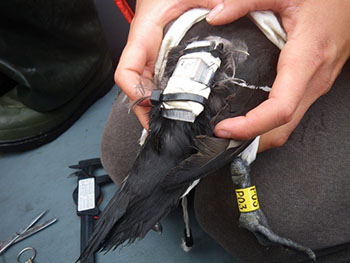
Individuals from each of these four species were caught on Île à Calculot des Betchouanes and Île de la Maison. Data recorders were then attached to the captured individuals (figure 1). These devices then recorded their movements for several days. In total, telemetric data were collected from three Atlantic Puffins, five Razorbills, six Black-legged Kittiwakes and twelve Common Murres.
Unique behaviours
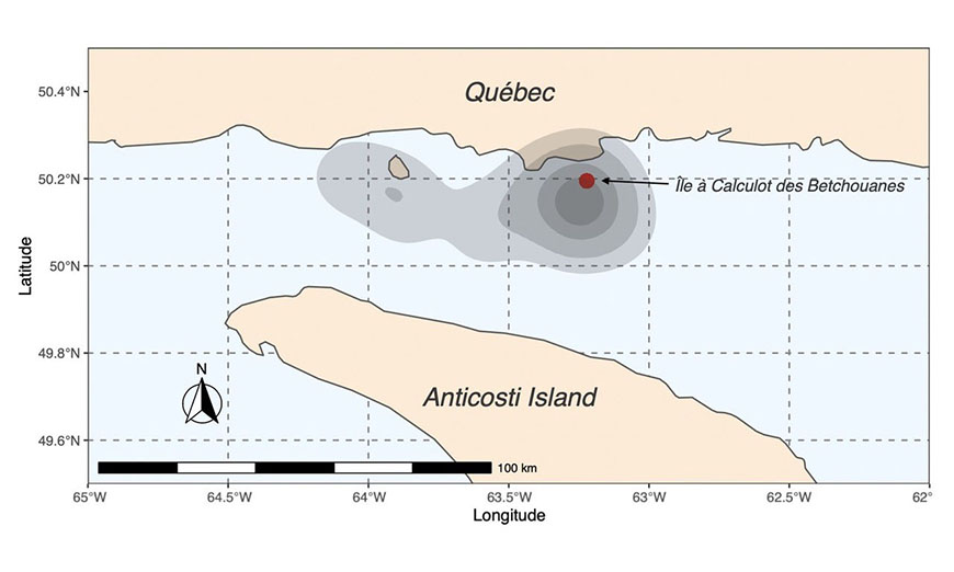
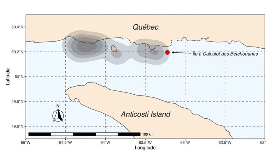
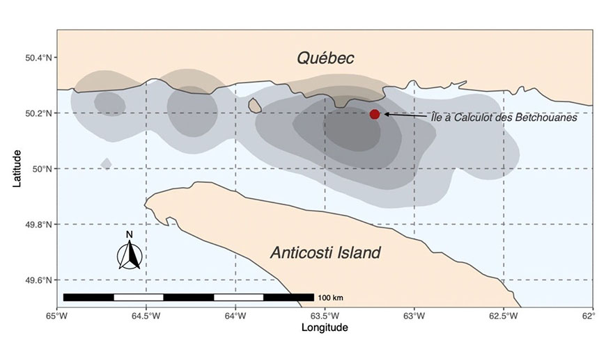
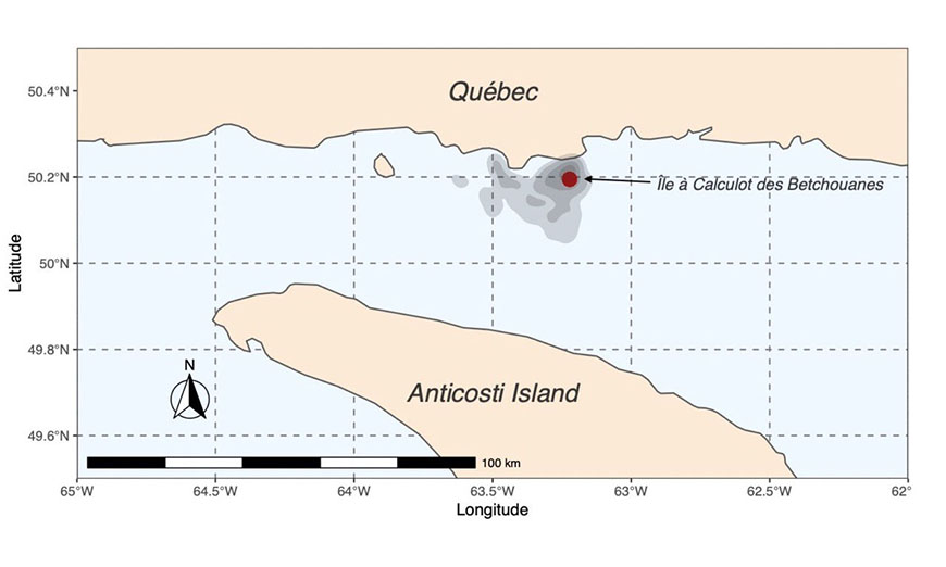
Certain feeding behaviours differ from one species to another (figure 2). For example, the distance travelled is not the same for all of them:
- Black-legged Kittiwakes: 56.7 ± 0.54 km
- Common Murres: 30.7 ± 0.63 km
- Razorbills: 7.22 ± 0.10 km
- Atlantic Puffins: insufficient data
Surprising observation: the longest distance covered was by a Common Murre which travelled 115 km to feed!
Identified sensitive areas
Although each species seems to sometimes adopt unique feeding behaviours, the data collected revealed the location of common feeding areas (figure 2) in sectors near:
- The Romaine, Mingan and Saint-Jean rivers: areas where fresh water intermixes with salt water;
- Île à Calculot des Betchouanes: an area near sea bird colonies.
These results are important to the Mingan Archipelago National Park Reserve. In addition to identifying areas to be protected in the event of an oil spill, this study demonstrates the importance of conserving the large marine ecosystem surrounding the islands in the Mingan Archipelago. The Canadian Wildlife Service and students from McGill University are continuing their research this year. Like the alcids and Black-legged Kittiwakes, we impatiently await their spring-time return and hope to see them plying the waters of the Gulf again soon!
Figure 2: Feeding zones
- Atlantic Puffins
- Black-legged Kittiwakes
- Common Murre
- Razorbills
The grey shaded areas represent the GPS distribution points collected within an area. The lighter grey areas represent 95% of the GPS points whereas the darker areas include 25% of the GPS points.
Authors
- Christina Petalas, student, McGill University
- Thomas Lazarus, student, McGill University
- Kyle Elliott, Assistant Professor, McGill University
- Mélanie Guigueno, Assistant Professor, McGill University
- Raphaël Lavoie, Biologist, Canadian Wildlife Service
- Marie-Claude Roy, Ecologist Team Leader, Parks Canada
References
- Petalas, C., Lazarus, T, Lavoie, R. A., Elliott, K. H., and Guigueno, M. F. 2021. Foraging niche partitioning in sympatric seabird populations. Scientific Reports 11: 2493, https://doi.org/10.1038/s41598-021-81583-z
Quote
- Roy, M.C.,Petalas, C., Lavoie, R. Elliot, K., Guigueno, M., Lazarus, T. 2020. Bird’s Eye View of Feeding Areas. - Telemetric monitoring of alcids and Black-legged Kittiwakes nesting in the Mingan Archipelago. The Conservation Chronicles. Mingan Archipelago National Park Reserve. Quebec, Canada. July 2020
Related links
- Date modified :